MyTopo
Historic 1942 Pomeroy Washington 30'x30' Topo Map
Couldn't load pickup availability
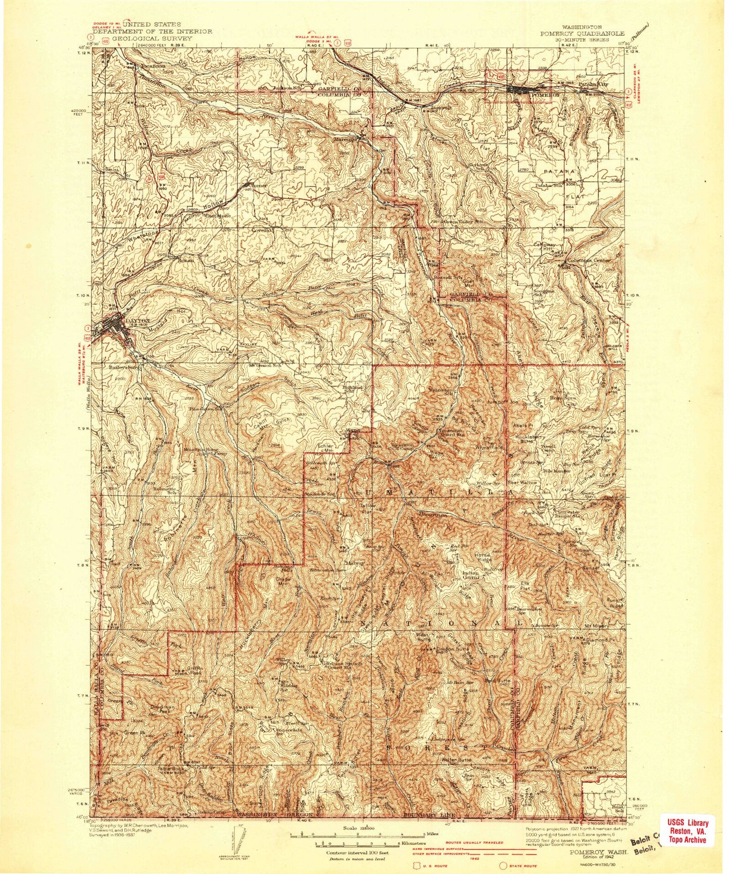
Historical USGS topographic map of Pomeroy in the state of Washington. Scale: 1:125000. Print size: 17" x 24"
This map was published in 1942 and is in the following counties: Columbia, Garfield, Umatilla, Walla Walla, Wallowa.
The map contains contour lines, roads, rivers, towns, streams, and lakes. Printed on high-quality waterproof paper with UV fade-resistant inks.
Contains the following named places: Grizzly Bear Ridge, Patterson Ridge, Rattlesnake Ridge, Wenaha-Tucannon Wilderness, Beaver Ridge, Abels Point, Al Williams Ridge, Alder Thicket Campground, Ant Flat, Arbothknott Canyon, Baker Pond, Bear Cave Ridge, Bear Creek, Bear Creek Trail, Beaver Lake, Benjamin Gulch, Big Four Canyon, Bihmaier Gulch, Billups Gulch, Blue Lake, Box Canyon, Brown Gulch, Buck Ridge, Buckley Ridge, Burnt Flat, Burnt Fork, Calloway Hill, Camp Mead, Camp Wooten State Park, Carvers Gulch, Chaparral Basin, Cherry Creek, Coates Creek, Cold Creek, Columbia Center, Connors Gulch, Cougar Canyon, Cougar Canyon, Cougar Creek, Cougar Ridge, Cow Canyon, Coyote Creek, Crall Hollow, Cummings Creek, Danger Point, Davis Hollow, Day Ridge, Dayton, Deadman Creek, Deep Saddle Creek, Devils Eyebrow, Dexter Ridge, Dickinson Creek, Dry Pataha Creek, Dutch Flat, East Fork Butte Creek, Elk Flat, First Creek, First Creek Cabin, French Ridge, Gates Gulch, Geiger Gulch, Green Fly Canyon, Green Fork, Green Fork, Green Ridge, Griffin Fork, Griffin Peak, Grizzly Bear Ridge, Grub Canyon, Happy Valley, Hard-to-get-to Ridge, Harmony Community Hall, Hatley Gulch, Hatten Well, Hixon Canyon, Hompegg Falls, Hopkins Ridge, Horse Ridge, Indian Corral, Intake Trail, Ireland Gulch, Jim Creek, Johnson Hollow, July Ridge, Jumpoff Joe, Kendall Monument, King Creek, Lady Camp, Lewis Creek, Lewis Hollow, Linville Gulch, Little Tucannon River, Lost Point Ridge, Lost Ridge, Martin Ridge, Meadow Creek, Melton Creek, Middle Point Ridge, Mill Canyon, Mount Misery, Monument Ridge, Mountain Home Park, Mustard Hollow, North Fork Mill Creek, North Fork Touchet River, North Patit Creek, Paige Ridge, Panjab Campground, Panjab Creek, Pataha Campground, Pataha Flat, Patit Creek, Powell Camp, Preacher Creek, Rainbow Creek, Rainbow Lake, Rattlesnake Trail, Robinson Fork, Rodgers Gulch, Ruchert Camp, Saddle Creek, Salter Trail, Sawtooth Ridge, School Canyon, Scoggin Ridge, Second Creek, Sheep Creek, Sheephead Corral, Simpson Ridge, Slide Canyon, Smooth Ridge, South Fork Touchet River, Spangler Creek, Spoonamore Canyon, Spruce Spring Campground, Squaw Peak, Starvout Ridge, Stevens Ridge, Stockade Spring Campground, Sunflower Flat, Table Camp, Tallow Flat, Tepee Campground, The Wheatfield, Third Creek, Trout Creek, Tucannon Campground, Tucannon Guard Station, Turkey Creek, Turner, Twin Buttes, Unfried Ridge, Waterman Gulch, Weidman Gulch, Welch Ridge, West Butte Ridge, West Fork Butte Creek, West Fork First Creek, West Patit Creek, Whitney Creek, Willow Creek, Willow Creek, Wolf Fork, Yearling Ridge, Grizzly Bear Trail, East Butte Creek Trail, West Butte Creek Trail, Packer Trail, July Ridge Trail, Melton Creek Trail, Tucannon River Trail, Burnt Flat Corral, Sawtooth Trail, Dexter Ridge Trail, Slick Ear Trail, Panjab Trail, Turkey Creek Trail, Meadow Creek Trail, Rickman Gulch, Tatman Gulch, Baileysburg, Covello, Marengo, Mountain Top, Patit, Ronan, Stentz Spring, Tucannon, Whetstone, Zumwalt, Midway, Clearwater Guard Station, Kelly Camp, Big Spring Campground, Godman Guard Station, Bear Wallow, Bear Ridge, Clearwater, Hutchens Gulch, Bald Butte, Cahill Mountain, Chase Mountain, Deadman Peak, Diamond Peak, Eckler Mountain, Fuzzy Butte, Goat Mountain, Green Peak, Halsey Butte, Huckleberry Butte, Lewis Peak, Lost Point, Maloney Mountain, Newby Mountain, Oregon Butte, Pataha, Pomeroy, Robinette Mountain, Rose Springs, Sugarloaf, Table Rock, Tatman Mountain, Weller Butte, West Butte, Abels Ridge, Big Turkey Tail, East Fork First Creek, Little Turkey Tail, Tumalum Creek, Columbia County, Spring Lake, Watson Lake, Tucannon Game Reserve, Camp Wooten Environmental Learning Center, Wooten Game Reserve