MyTopo
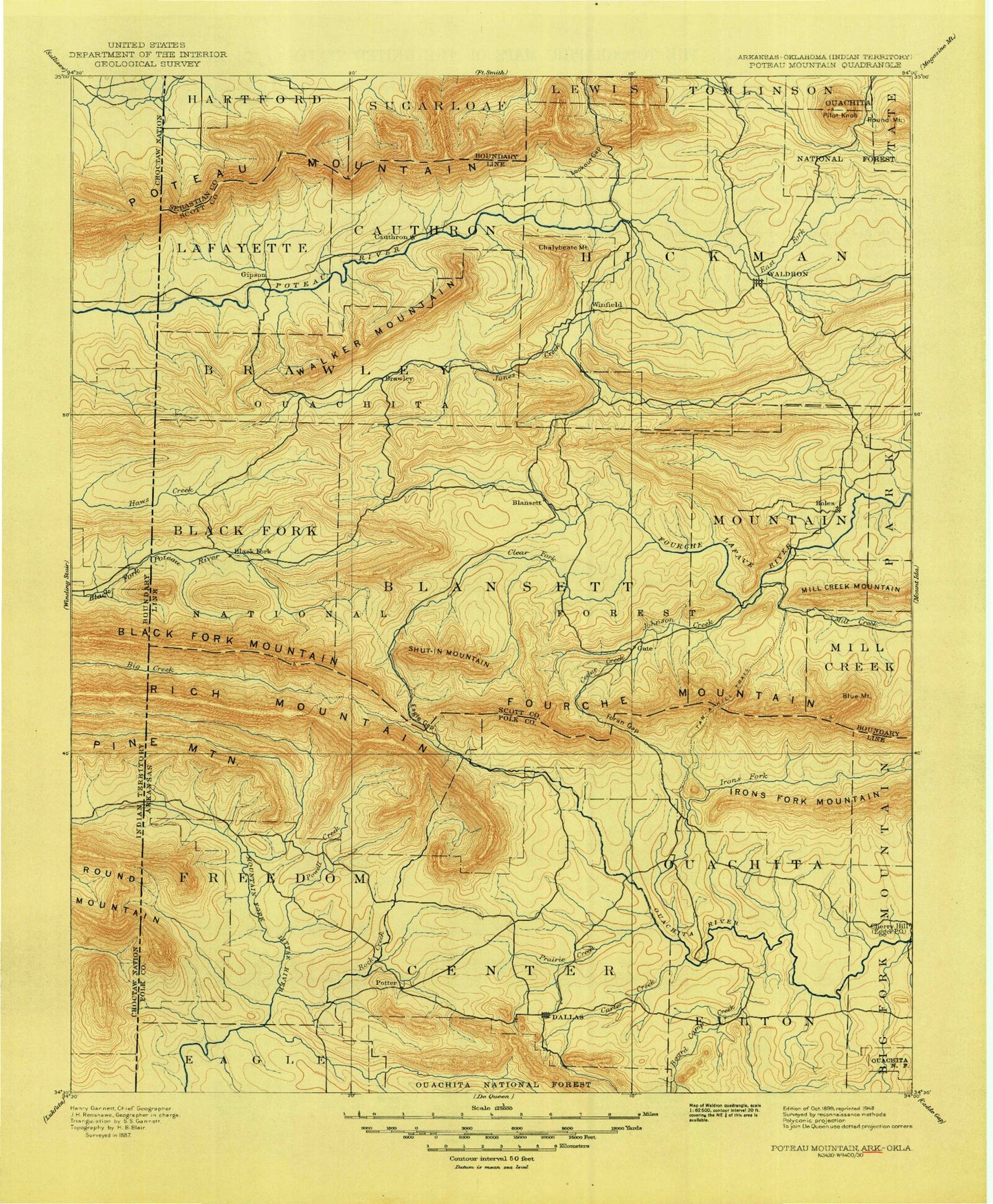
Historic 1899 Poteau Mountain Arkansas 30'x30' Topo Map
Couldn't load pickup availability
Historical USGS topographic map of Poteau Mountain in the state of Arkansas. Scale: 1:125000. Print size: 18" x 24"
This map was published in 1899 and is in the following counties: Le Flore, McCurtain, Polk, Scott, Sebastian.
The map contains contour lines, roads, rivers, towns, streams, and lakes. Printed on high-quality waterproof paper with UV fade-resistant inks.
Contains the following named places: Center Point, Corinth, Gap Creek Valley, Northside Shopping Center, Olivers Chapel, Pine Grove, Posey Hollow, Shady Grove, West Valley, Yocana, Lee McMillian Memorial Park, Lionsk Club Golf Course, Ouachita Country Club, Polk County Fairgrounds, Denton, Evening Shade, Green Ridge, Keener, Lone Elm, Morgan Springs, Pleasant Hill, Pleasant Valley, Poteau Ouachita National Forest Work Center, Shiloh, Sodie Davidson Park, Steep Hollow Creek, Truman Baker Park, Township of Acorn, Township of Cedar, Township of Eagle, Township of Fulton, Township of Mountain, Township of Potter, Township of Black Fork, Township of Blansett, Township of Brawley, Township of Cauthron, Township of Coal, Township of Denton, Township of Hickman, Township of Hon, Township of Lafayette, Township of Mill Creek, Township of Mountain, Township of Oliver, Scott County, Self Branch, Alum Fork, Apex, Basin Hollow, Bates, Beauchamp, Big Cedar Creek, Big Creek, Big Creek, Black Fork Mountain, Blansett, Blowout Mountain, Blue Mountain, Board Camp, Board Camp Creek, Boggy Creek, Bohnstein Hill, Brawley, Brier Creek, Briery Creek, Bruce Mountain, Brushy Hollow, Brushy Mountain, Bruton Ridge, Buffalo Creek, Buffalo Mountain, Bufram Creek, Hon Branch, Bryan, Calvin Branch, Camp Pioneer, Campbell Hollow, Cane Creek, Carter Creek, Cedar Creek, Cedar Creek, Cedar Creek, Negro Creek, Cedar Creek, Cedar Creek, Cedar Mountain, Chalybeate Mountain, Chances Creek, Choctaw Creek, Clear Creek, Clear Fork, Coaldale, Collins Creek, Countis Creek, Cow Creek Mountain, Cross Creek, Cross Creek Mountain, Dallas Creek, Dallas Mountain, Denton Creek, Denton Creek, Dogwood Flats, Dry Branch, Dry Creek, Eagle Gap, Eagle Gap Ranger Station, Eagleton, East Fork Poteau River, East Fork Powell Creek, East Poteau Mountain, East Shadley Creek, Fogel, Foran Gap, Fourche Mountain, Gap Creek, Gap Creek, Gipson, Goldsberry Mountain, Grassy Ridge, Gum Branch, Harvey Ridge, Haw Creek, Heath Creek, Henderson Mill Hollow, Henry Branch, Hickory Knob, High Peak, High Point Camp, High Point Mountain, Hon, Horsepen Creek, Horseshoe Mountain, Howard, Ink, Janssen Park, Jerico Branch, Johnson Creek, Joshling Creek, Kelsey Mountain, Key Mountain, Lamb Mountain, Lewis Creek, Lick Branch, Little Buffalo Creek, Little Cedar Creek, Little Cross Creek, Little Mountain, Little Round Mountain, Loftis Creek, Long Branch, Long Mountain, McNally Creek, Lookout Gap, Loving Creek, Mackey Creek, Macks Creek, McKinney Creek, Mena, Merren Creek, Middle Mountain, Middle Mountain, Mill Creek, Mill Creek, Mill Creek, Mill Race, Mitchell Creek, Mitchell Ridge, Mountain Fork, Mud Creek, Muddy Creek, Needmore, Nichols Branch, Northern Creek, Nunley, Oliver, Oliver Branch, Patterson, Peanut Mountain, Phipps Branch, Pigeon Creek, Pilot Knob, Pilot Mountain, Pine Mountain, Piney Creek, Piney Mountain, Pitman Creek, Polk Creek, Pollock Branch, Posey Creek, Posey Hollow, Potter Junction, Potter Mountain, Powell Creek, Prairie Creek, Prairie Creek, Price Creek, Puryear, Queen Creek, Quentin Mountain, Ray Branch, Red Creek, Ritz, Robertson Branch, Robinson Creek, Rock Canyon, Rock Creek, Ross Creek, Ross Mountain, Rough Creek, Round Mountain, Round Mountain, Round Mountain, Round Mountain, Round Mountain, Round Top Mountain, Round Top Mountain, Rowdy Mountain, Russell Branch, Saddle Gap, Salt Creek, Scott Branch, Session Creek, Shadley Creek, Shut-In Mountain, Sixmile Creek, Slate Creek, Slaty Creek, Southern Creek, Square Rock Creek, Square Rock Ridge, Starkey Creek, Stevens Branch, Stewart Branch, Sulphur Creek, Tan-a-hill Creek