MyTopo
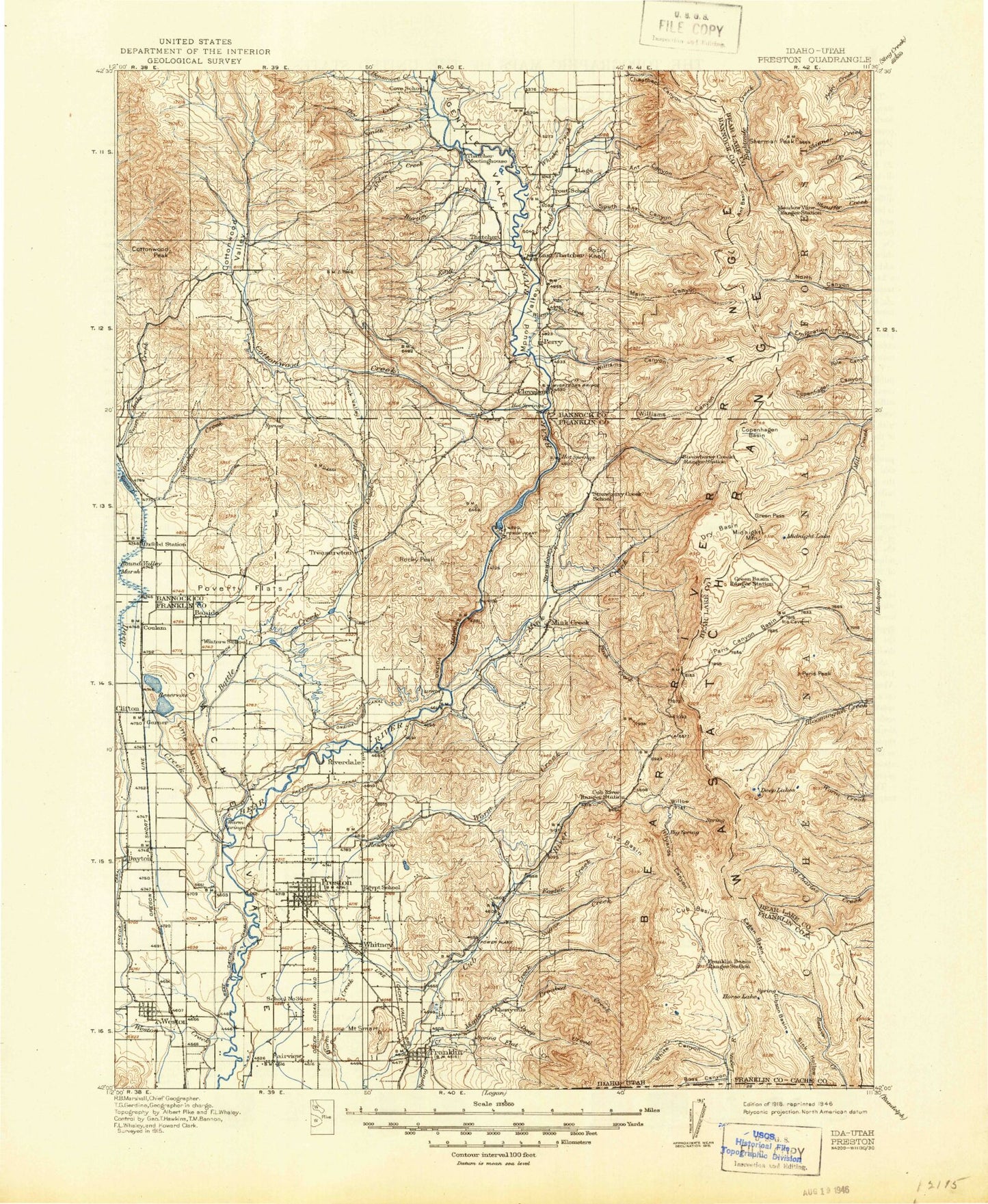
Historic 1918 Preston Idaho 30'x30' Topo Map
Couldn't load pickup availability
Historical USGS topographic map of Preston in the state of Idaho. Scale: 1:125000. Print size: 17" x 24"
This map was published in 1918 and is in the following counties: Bannock, Bear Lake, Caribou, Franklin.
The map contains contour lines, roads, rivers, towns, streams, and lakes. Printed on high-quality waterproof paper with UV fade-resistant inks.
Contains the following named places: Alder Creek, Battle Creek, Big Hill, Blue Creek, Bullwhacker Canyon, Cedar Hill, Cleveland Hill, Cottonwood Valley, Coyote Hollow, Cub Canal, Densmore Creek, Divide Creek, Dry Creek, Dry Hollow Mountain, Fairview, Foster Reservoir, Fox Canyon, Fox Hollow, Franklin, Heart Mountain, Hog Wallow, Hutchins Canyon, Jacobson Creek, Johnson Reservoir, Left Fork Mill Canyon, Lewis Creek, Little Mountain, Little Mountain, Lower Canal, Mill Canyon, Mine Hollow, Oneida Narrows, Pioneer Women Historical Monument, Poverty Flats, Right Fork Cottonwood Creek, Right Fork Mill Canyon, Rocky Peak, Sant Creek, Shingle Creek, Slide Canyon, Smith Creek, Stock Valley, Stockton Creek, Swan Lake, Tough Hollow, Treasureton, Treasureton Canal, Treasureton Hill, Twin Lakes Canal East Lateral, Twin Lakes Canal West Lateral, Upper Canal, Walker Gulch, West Cache Canal, West Canal, Weston, Winder, Winder Reservoir, Anderson, Albert Moser Campground, Balsam Hollow, Bear Creek, Bear Hollow, Beaver Creek Campground, Big Creek Lake, Birch Creek, Bloomington Lake Trail, Bloomington Peak, Blue Lake, Boss Canyon, Burton Creek, Camp Wilderness, Carter Creek, Cheatbeck Basin, Cheatbeck Canyon, Cherryville Flat, Cleveland Irrigation Canal, Cloverleaf Campground, Club River Guard Station, Copenhagen Basin, Copenhagen Canyon, Corral Hollow, Cottonwood Creek, Croney Hollow, Crooked Creek, Cub Basin, Cub River Worm Creek Canal, Danish Flat, Danish Pass, Deep Creek, Deep Hollow, Devils Hill, Dry Basin, Dry Creek, Dry Fork, Dry Hollow, East Canal, Egan Basin, Eightmile Campground, Emigration Campground, Emigration Canyon, Fivemile Creek, Foster Creek, Franklin Basin, Gem Valley, Gentile Valley, Gentile Valley Canal, Gibson Basin, Gooseberry Creek, Graham Hollow, Grandy Hollow, Green Basin, Green Pass, Grunder Hollow, Hale Mine, Harrys Hollow, Hell Hole, Hidden Lake, High Line Trail, Hillyard Canyon, Hodge Nibley Creek, Horse Basin, Horse Flat, Horse Lake, Horsehoe Basin, Hull Valley, Indian Flat, King Creek, Kuntz Creek, Left Fork Maple Creek, Liberty Creek, Limekiln Lake, Litz Basin, Litz Creek, Loa Lake, Mahogany Basin, Main Canyon, Maple Creek, Mapleton, Mass Canyon, Meadow Creek, Mercham Hollow, Middle Ditch, Middle Fork Bloomington Creek, Middle Fork North Canyon, Middle Fork Saint Charles Creek, Midnight Lake, Midnight Mountain, Mill Canyon, Mill Canyon, Mill Hollow, Mill Hollow, Mink Creek, Mink Creek Canal, Moonlight Meadow, Morgan Ridge, Mound Valley, North Ant Basin, North Ant Canyon, North Canyon, North Fork Bloomington Creek, North Fork Saint Charles Creek, North Pearl Creek, North Skinner Creek, North Worm Creek Basin, Oneida Narrows Reservoir, Oxford Slough, Oxkiller Canyon, Paris Flat, Paris Peak, Pat Hollow, Peterson Hollow, Pole Canyon, Porcupine Campground, Porcupine Hollow, Post Hollow, Preston Riverdale Canal, Red Pine Ridge, Red Sinks, Relief Society Hollow, Right Fork Williams Creek, Schoolhouse Hollow, Self Help Hollow, Sheep Dip Hollow, Sherman Peak, Snow Hollow, Snowslide Canyon, South Ant Basin, South Ant Canyon, South Canyon, South Cheatbeck Basin, South Fork Bloomington Creek, South Fork Dry Creek, South Fork North Canyon, South Fork Paris Canyon, South Fork Saint Charles Creek, South Skinner Creek, South Worm Creek Basin, Spring Creek, Flat Canyon, Spring Hollow, Squirrel Hollow, Station Creek, Station Creek Tunnel, Stewart Fork, Strawberry Canyon, Strawberry Creek, Sugar Creek, Swainston Hollow, Swan Lake Slough, Telegraph Flat, The Sinks, Trout Creek, Trout Creek Canyon, Twin Lakes Canal, Water Fork, Weston Creek, Whiskey Creek, White Canyon, Wiggler Lake, Williams Canyon, Williams Creek, Willow Flat, Wills Canyon, Worm Lake, Cheatbeck Creek, Beers Spur, Dayton Siding, Franklin County, Cleveland, Glendale, Cherryville, Cottonwood Peak, Egypt, Mink Creek, Mound Valley, Whitney