MyTopo
Historic 1896 Pryor Oklahoma 30'x30' Topo Map
Couldn't load pickup availability
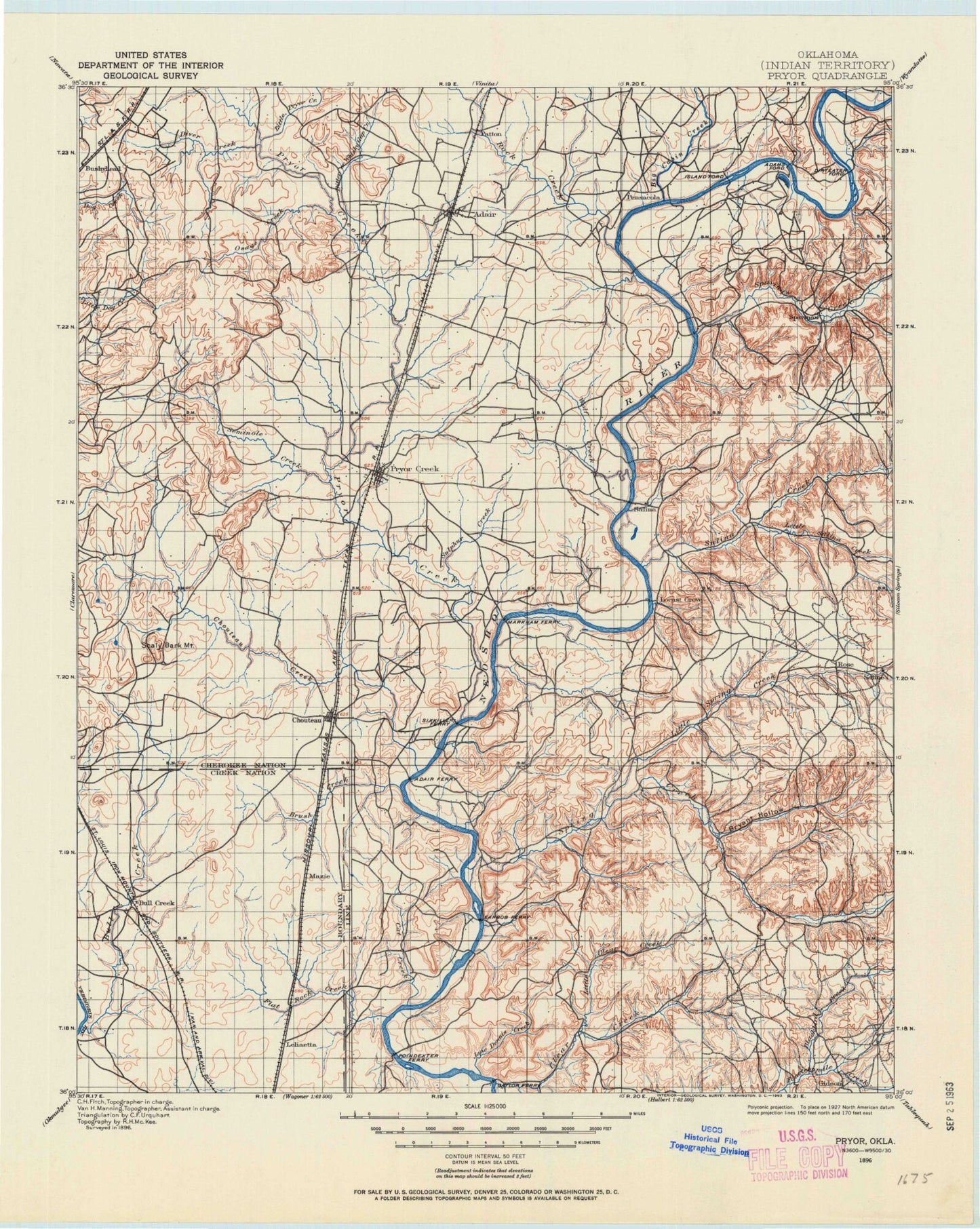
Historical USGS topographic map of Pryorin the states of Oklahoma, Arkansas. Scale: 1:125000. Print size: 18" x 24"
This map was published in 1896 and is in the following counties: Cherokee, Delaware, Mayes, Rogers, Wagoner.
The map contains contour lines, roads, rivers, towns, streams, and lakes. Printed on high-quality waterproof paper with UV fade-resistant inks.
Contains the following named places: Spring Creek Recreation Area, Adair, Armstrong Branch, Bald Knob, Ballou Branch, Benge Branch, Big Bend, Big Cabin Creek, Big Hollow Creek, Big Hollow Public Use Area, Bitter Creek, Black Hollow, Blackbird Creek, Blacksmith Hollow, Blue Bill Point Public Use Area, Brush Creek, Bryant Creek, Bull Creek, Calven Hollow, Camp Christian, Camp Garland, Camp Scott, Cat Creek, Cedar Crest, Cedar Crest Lake, Chapel Branch, Chicken Hollow, Chimney Rock Hollow, Chouteau, Chouteau Bend North Public Use Area, Chouteau Bend South Public Use Area, Chouteau Creek, Clear Creek, Coleman Hollow, Crutchfield Branch, Davis Hollow, Disney, Diver Creek, Dry Hollow, Earbob Ferry Recreation Area, Earl Ward Park, Elm Creek, Flat Rock Bay, Flat Rock Creek, Flat Rock Creek Public Use Area, Granny Branch, Hadley Mountain, Hare Branch, Hogskin Hollow, Inola Hill, Jane Dennis Creek, Jesse James Hill, Kingfisher Hollow, Langley, Little Clear Creek, Little Pryor Creek, Little Saline Creek, Little Spring Creek, Locust Grove, Low Water Dam Public Use Area, Mazie, Mazie Landing Public Use Area, Mission Bend Public Use Area, Mud Creek, Mustang Creek, Neely Mountain, Osage Creek, Osage Hills, Osage Mound, Paradise View, Peggs, Pensacola, Pensacola Dam, Pipe Spring Branch, Pryor Creek, Robert S Kerr Dam, Rock Creek, Rocky Point, Rose, Salina, Saline Creek, Salt Branch, Scaly Bark Mountain, Scarbow Lake, Seminole Creek, Snake Creek, Snodale Recreation Area, Snug Harbor Public Use Area, Spavinaw, Spavinaw Creek, Spavinaw Dam, Spavinaw Lake, Spring Creek, Squaw Hollow, Strang, Sulphur Creek, Summerfield Creek, Tag Hollow, Three Fingers Bay Public Use Area, Tia Juana, Timber Ridge, Westside Park, Whiskey Gap, Whitaker Park, Whitehorn Cove Public Use Area, Wickliffe Creek, Wolf Creek, Wooded Hollow, Yokum Hollow, Boatman, Bushyhead, Gideon, Green, Harmony Star, Hisle, Howard, Leliaetta, Lusta, Murphy, Neodesha, Patton, Pin Oak Acres, Tip, Yonkers, Mayes County, Lake Hudson, City of Adair Waterworks, City of Vinita Water Intake, City of Tulsa Water Intake, Grand River Pumping Station, Pryor Water Intake, Recreation Area Number 1, Recreation Area Number 2, Recreation Area Number 3, Pryor, Sportsmen Acres, Hoot Owl, Polone Dam, Polone Reservoir, Spavinaw Dam, Oknoname 131010 Dam, Oknoname 131010 Reservoir, Oknoname 145001 Dam, Oknoname 145001 Reservoir, Scarbow Lake Dam, Dr Williams Pond Number 5 Dam, Dr Williams Pond Number 5, Whitaker Home Pond Dam, Whitaker Home Pond, Markham Ferry Dam, Pensacola Dam, Chimney Rock Dam, Chimney Rock Reservoir, Spavinaw State Park, Little Blue-Disney State Park, Cherokee State Park, Salina State Park, Chimney Rock Lake, Sportsman Acres, Snowdale State Park, Keith, Center 69, Tiger Plaza, Rowes Prairie, Squaw Creek, Township of Rider, Township of Adair, Township of River, Township of Hogan, Township of Center, Township of Saline, Township of Chouteau, Township of Bryan, Township of Mazie, Township of Murphy, Township of Creek, Township of Cherokee, Township of Peggs, Ballou, Iron Post, Snake Creek, Adair Division, East Mayes Division, Locust Grove Division, Pryor Creek Division, City of Pryor Creek, Town of Adair, Town of Disney, Town of Hoot Owl, Town of Langley, Town of Locust Grove, Town of Pensacola, Town of Chouteau, Town of Salina, Town of Spavinaw, Town of Sportsmen Acres, Town of Strang, Ballou, Cedar Crest, Gideon, Iron Post, Lost City, Mayes Non-Community, Mazie, Murphy, Peggs Community, Pin Oak Acres, Pump Back, Rose, Sams Corner, Snake Creek, Sportsmen Acres Community, Wickliffe, Little Rock, Whitehorn Cove, Spavinaw Creek