MyTopo
Historic 1943 Punxsutawney Pennsylvania 30'x30' Topo Map
Couldn't load pickup availability
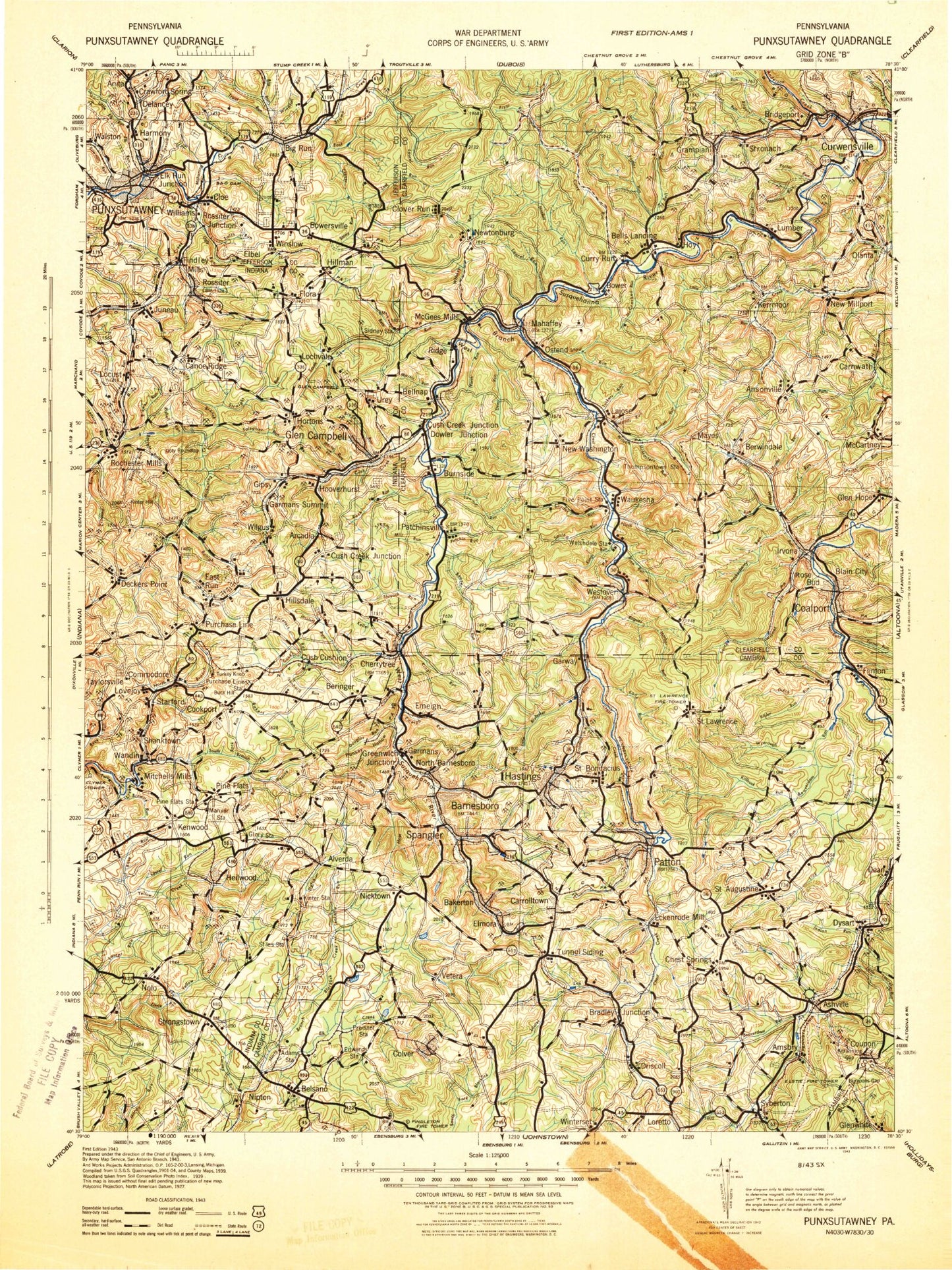
Historical USGS topographic map of Punxsutawney in the state of Pennsylvania. Scale: 1:125000. Print size: 16" x 24"
This map was published in 1943 and is in the following counties: Blair, Cambria, Clearfield, Indiana, Jefferson.
The map contains contour lines, roads, rivers, towns, streams, and lakes. Printed on high-quality waterproof paper with UV fade-resistant inks.
Contains the following named places: Albion, Allport, Alverda, Amsbry, Anderson Creek, Ansonville, Ashville, Bakers Crossroad, Bakerton Reservoir, Barnes, Barnesboro, Barrett Run, Barrett Run, Bear Run, Beaverdam Run, Beech Run, Bell Run, Bells Landing, Bells Mills, Belsano, Belsano Camp, Bencetown, Berwinsdale, Bethlehem, Big Run, Big Run, Bilger Run, Blain City, Blain Run, Bloomington, Blue Goose, Bowersville, Bradley Run, Bretonville, Brewer Run, Broadhead Run, Browns Run, Browns Run, Browns Run Reservoir, Buck Hill, Buck Run, Burgoon Run, California Run, Camp Corbly, Camp Meeting Grounds, Campbell Run, Canoe Creek, Canoe Ridge, Carney Run, Carnwath, Carrolltown, Carrolltown Reservoir, Carrolltown Road, Carson Run, Charlies Grove, Cherry Tree, Chest Creek, Chest Springs, City Reservoir, Cloe, Cloe Lake, Clover Run, Coalport, Cold Spring Run, Colver, Comfort Run, Commodore, Cookport, Couch Run, Coupon, Crawfordtown, Crooked Run, Crooked Run, Curry Run, Curry Run, Curwensville, Curwensville Lake, Cush Cushion Creek, Daily Run, Davidson Run, Davis Dam, DeWitt Hill, DeWitt Run, Dean, Deckers Point, Diamondville, Dickerman Hill, Dotts Hollow, Douglas Run, Downey Run, Driscoll Hollow, Duclos Run, Duman Lake, Duman Lake Park, Dysart, East Branch Mahoning Creek, East Run, East Run, Eckenrode Mill, Elk Creek, Elk Run, Elstie, Emeigh, Emeigh Run, Erhard, F Portal, Fairview, Fenton Run, Flinton, Fiske, Fox Run, Foxburg, Friendship Tunnel, Fryor Run, Garmantown, Gazzam Run, Glen Hope, Glendale Dam, Glendale Lake, Gobblers Knob, Good, Graffius Run, Grampian, Green Run, Greenfield, Greenwich, Griffithtown, Grisemore, Harmony, Harmony, Haslett Run, Hastings, Hazelet Run, Heilwood, Hepburnia, Hess Run, Hiles Run, Hill Creek, Hillsdale, Holes Run, Hoyt Tunnel, Hughey Run, Hunter Run, Irish Run, Irishtown, Irvin Park, Irvona, Isenberg Run, Jackson Run, Jewtown, Jones Portal, Kenwood, Kerrmoor, Kibler Run, Killbuck Run, Kilns Run, Kings Run, Kings Run, Kinter Hill, Kratzer Run, Laurel Branch Run, Laurel Lick Run, Laurel Run, Laurel Run, Laurel Run, Laurel Run, Laurel Run Lake, Learn Settlement, Leasure Run, Leonard Run, Lesle Run, Little Brubaker Run, Little Elk Creek, Little Elk Run, Little Killbuck Run, Little Laurel Run, Living Waters Camp, Lonely Acres, Long Run, Long Run, Loretto, Loretto Road, Lost Run, Lovejoy, Lumber City, Lyleville, Manor, Manver Station, Marsteller, McCartney, McCracken Run, McDonald Run, McGees Mills, McMasters Run, McPherron, Mentcle, Middleton, Miller Run, Morgans Land, Moss Creek, New Millport, New Washington, Newburg, Newtonburg, Nicktown, Nine Row, Nolo, North Barnesboro, North Branch Straight Run, North Branch Two Lick Creek, North Witmer Run, Olanta, Ostend, Painter Run, Painters Run, Passmore Run, Patton, Peg Run, Pindleton, Pine Flats, Pine Run, Pine Run, Pineton, Pioneer Lake, Pompey Run, Poplar Run, Portal Number 1, Portal Number 15, Porter Run, Porter Run, Prince Gallitzin State Park, Punxsutawney Reservoir, Purchase Line, Raccoon Run, Rairigh Run, Rattling Run