MyTopo
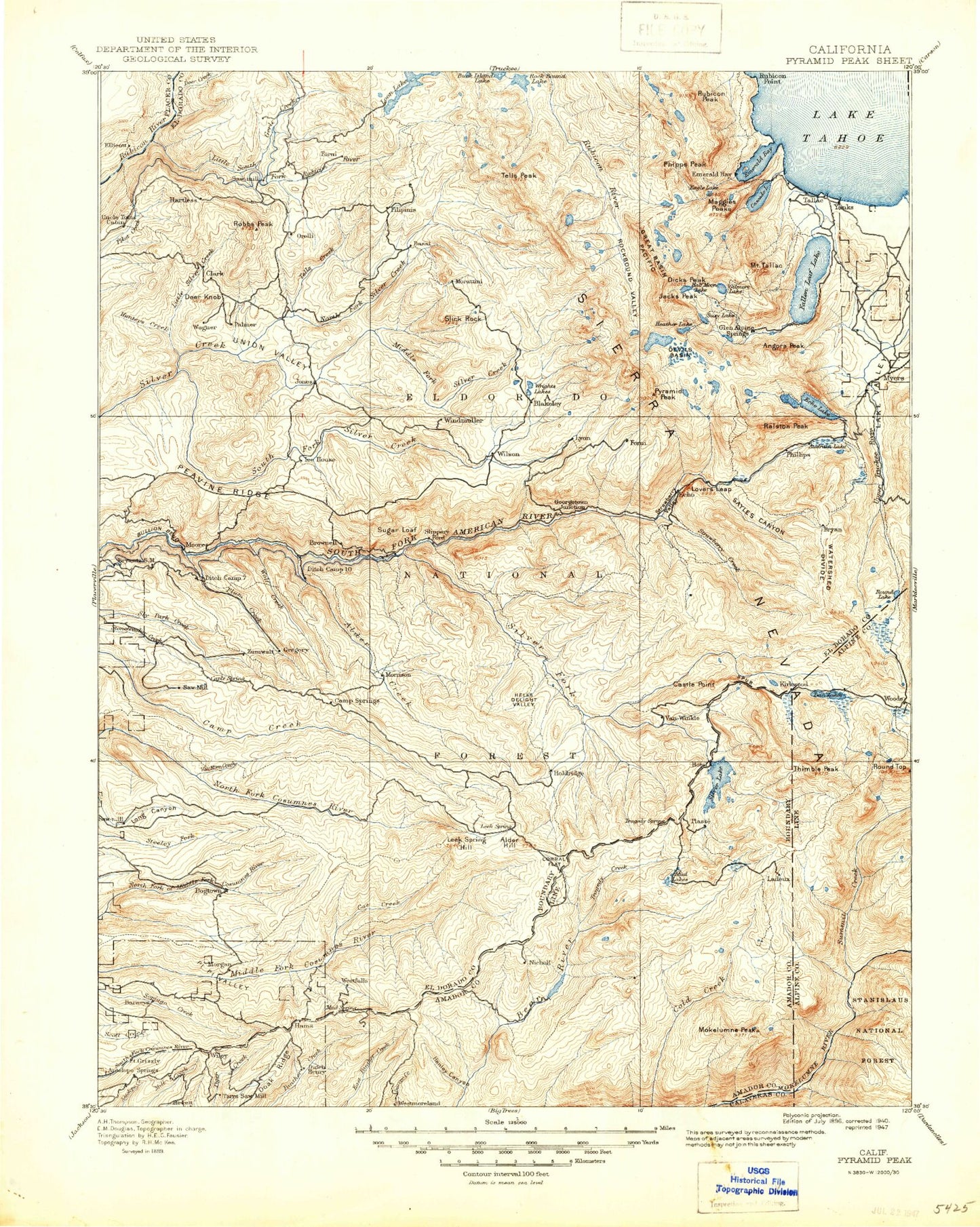
Historic 1896 Pyramid Peak California 30'x30' Topo Map
Couldn't load pickup availability
Historical USGS topographic map of Pyramid Peak in the state of California. Scale: 1:125000. Print size: 17" x 24"
This map was published in 1896 and is in the following counties: Alpine, Amador, Calaveras, Douglas, El Dorado, Placer.
The map contains contour lines, roads, rivers, towns, streams, and lakes. Printed on high-quality waterproof paper with UV fade-resistant inks.
Contains the following named places: Alta Morris Lake, Baldwin Beach, Bark Sharrly Canyon, Barrett Lake, Brown Rock, Camper Flat, China Flat, Cliff Lake, Cody Meadow, Corral Flat, Crag Lake, Dark Canyon, Dennis Canyon, Dicks Lake, Dicks Pass, Dicks Peak, Lake Doris, Fontanillis Lake, Four-Q Lakes, Fox Lake, Lake Genevieve, Gertrude Lake, Girard Creek, Grouse Lakes, Half Moon Lake, Hells Delight Creek, Hells Delight Valley, Hidden Lake, Highland Lake, Horse Canyon, Horseshoe Lake, Iron Mountain, Jacks Peak, Lake Valley, Lawrence Lake, Leek Spring Hill, Leland Lakes, Light Canyon, Lake Lois, Lost Lake, Lost Lake, Lower Velma Lake, Lake Margaret, Martell Flat, Martin Creek, Martin Meadow, Maude Lake, McConnell Lake, McConnell Peak, Meiss Lake, Middle Mountain, Middle Velma Lake, Mosquito Pass, North Creek, North Tragedy Creek, Onion Flat, Osgood Swamp, Phipps Creek, Phipps Lake, Phipps Pass, Phipps Peak, Red Peak, Rockbound Pass, Rubicon Lake, Rubicon Peak, Rubicon Reservoir, Lake Schmidell, Shadow Lake, Shaw Flat, Shealor Lakes, Sherman Canyon, Silver Peak, Lumberyard Ranger Station, Middle Fork Camp Creek, South Fork Camp Creek, Spicer Canyon, Spicer Meadow, Stony Ridge Lake, Top Lake, Tyler Lake, University of California Cow Camp, Upper Velma Lake, White, Willow Flat, Willow Flat, Willow Flat Creek, Lake Zitella, Jakes Peak, Hay Flat, Loon Lake, Lake Number Three, Lake Number Five, Lake Number Nine, Alder Creek, Alder Creek Camp Ground, Lake Aloha, Alpine Campground, American Lake, Angel Creek, Angora Creek, Angora Lakes, Angora Lookout, Angora Peak, Arbor Mine, Armstrong Hill, Aspen Creek, Atherton Flat, Lake Audrian, Avalanche Lake, Azure Lake, Bald Mountain, Baltic Ridge, Barney Meadow, Barney Ridge, Bassi Falls, Bassi Fork, Bay View Guard Station, Beanville Creek, Bear Meadow, Bear Meadow Creek, Beauty Lake, Beebe Lake, Benwood Meadow, Berkeley Municipal Camp, Berts Lake, Big Hill, Big Hill Canyon, Big Hill Ridge, Big Hill Trail, Big Meadow Creek, Big Pebble Canyon, Big Silver Creek, Black Rock Lake, Blackbird Camp Ground, Bloodsucker Lake, Blue Mountain, Bobs Cabin Trail, Boomerang Lake, Bosworth Meadow, Brandon Canyon, Brockliss Canyon, Brown Mountain, Bryan Creek, Bryan Meadow, Buck Pasture, Bull Creek, Cagwin Lake, Caldor Ranger Station, Camp Cody, Camp Eldorado, Camp Harvey West, Camp Irene, Camp Sacramento, Caples Lake, Carpenter Creek, Carson Spur, Cascade Creek, Cascade Lake, Castle Point, Cathedral Creek, Cathedral Lake, Cathedral Peak, Cedar Camp, Celio Ranch, Channel Lake, Cheese Camp Creek, Cheese Camp Ridge, Chimney Flat, China Flat, Chipmunk Bluff, Clyde Lake, Cody Creek, Cody Lake, Cold Canyon, Cole Creek Lakes, Cooks Station, Cooks Station Ridge, Cox Canyon, Cracked Crag, Crystal Range, Cup Lake, D.L. Bliss State Park, Dardanelles Lake, Dark Lake, Darlington Flat, Deadwood Canyon, Deer Creek, Deer Knob, Desolation Lake, Desolation Valley, Devils Hole Lake, Dew Drop Fire Control Station, Ditch Camp, Ditch Camp Four, Ditch Camp One, Ditch Camp Three, Ditch Camp Two, Dixon Canyon, Doaks Ridge, Dry Lake, Dry Lakes, Dry Lakes Trail, Duncan Corral, Eagle Falls, Eagle Falls Campground, Eagle Lake, Eagle Point, Eagle Rock, Echo Peak, Echo Portal, Echo Summit, El Dorado Ditch, Elbert Lake, Elkins Flat, Ellicott Trail, Emerald Bay, Emerald Bay State Park, Emerald Point, Emigrant Lake, Esmeralda Creek, Fallen Leaf Campground, Fallen Leaf Lake, Fannette Island, Farnham Ridge, Firs Campground, Five Corners, Flagpole Peak, Floating Island Lake, Forni Creek, Forni Lake, Forni Lake, Fort Grizzly Site, Fortyfive Mile Campground, Fortytwo Mile Campground, Four Cornered Peak, Four Lakes