
MyTopo
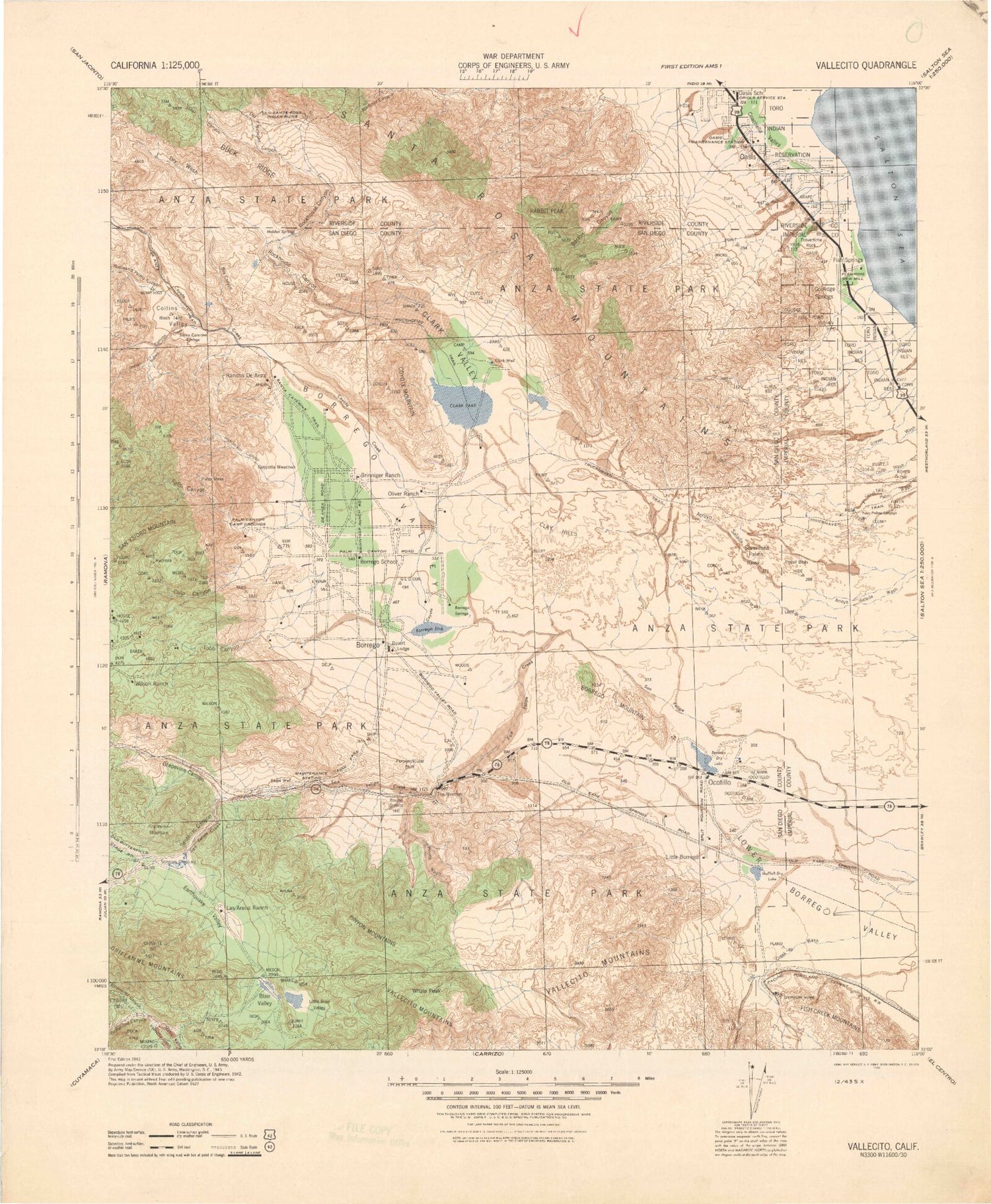
Historic 1943 Rabbit Peak California 30'x30' Topo Map
Couldn't load pickup availability
Historical USGS topographic map of Rabbit Peak in the state of California. Scale: 1:125000. Print size: 19" x 24"
This map was published in 1943 and is in the following counties: Imperial, Riverside, San Diego.
The map contains contour lines, roads, rivers, towns, streams, and lakes. Printed on high-quality waterproof paper with UV fade-resistant inks.
Contains the following named places: Alcoholic Pass, Anza-Borrego Desert State Park Headquarters, Barton Canyon, Bennis Bowl, Benson Lake, Big Wash, Bighorn Canyon, Bitter Creek Canyon, Blair Valley, Blair Valley Ranger Station, Blow Sand Canyon, Borrego Badlands, Borrego Mountain Wash, Borrego Palms Resort, Borrego Sink, Borrego Sink Wash, Box Canyon, Buttes Canyon, Buttes Pass, Cactus Garden, Cactus Valley, Calcite Mine, Calcite Road, Chimney Rock, Chimney Rock Ranch, Chuckwalla Canyon, Chuckwalla Wash, Clark Lake, Coachwhip Canyon, Coyote Mountain, Culp Canyon, Culp Valley, Deering Canyon, Dry Canyon, Earthquake Valley, East Fork Lizard Canyon, El Vado Historical Marker, Elephant Tree Area, Ella Wash, Fault Wash, Fonts Point, Fonts Point Wash, Foot and Walker Pass, Galleta Meadows, Garner Wash, Grapevine Canyon, Grapevine Hills, Grapevine Mountain, Halfhill Lake, Hapaha Flat, Harper Canyon, Harper Flat, Hawk Canyon, Hellhole Canyon, Hellhole Flat, Henderson Canyon, Hills of the Moon Wash, Indian Creek, Inspiration Point, Kenyon Cove, Little Blair Valley, Little Borego, Little Clark Lake, Lizard Canyon, Loki Canyon, Los Puertecitos Historical Marker, Maidenhair Falls, Mine Canyon, Mine Wash, Mud Palisades, Natural Rock Tanks, Nolina Wash, North Fork Arroyo Salada, North Fork Palm Wash, Nude Wash, Oasis, Oasis Lateral, Ocotillo Badlands, Ocotillo Flat, Old Overland Stage Route, Palo Verde Canyon, Palo Verde Ranger Station, Palo Verde Wash, Panorama Outlook, Pegleg Smith Historical Marker, Perpendicular Bluff, Pinyon Canyon, Pinyon Mountain Valley, Pinyon Ridge, Pinyon Wash, Plum Canyon, Powder Dump Wash, Pumpkin Patch, Quartz Vein Wash, Rainbow Rock, Rainbow Wash, Rancho De Anza, Rattlesnake Canyon, Rockhouse Trail, Round Granite Hill, Sentenac Canyon, Sentenac Mountain, Sentence Cienaga, Seventeen Palms, Sheep Canyon, Sheep Canyon Ranger Station, Shell Reef, Short Wash, Sleepy Hollow, Smoke Tree Canyon, Smoke Tree Wash, South Fork Hellhole Canyon, South Fork Palm Wash, Split Mountain, Split Rock, Squaw Peak, Stag Cove, Stone Wash, Sunset Mountain, Sunset Wash, Tamarisk Grove Campground, The Narrows, The Slot, The Thimble, Third Wash, Travertine Palms Wash, Truckhaven Trail, Tubb Canyon, Valley of the Thousand Springs, Villager Peak, Vista del Malpais, Vista del Malpais Wash, West Butte, West Fork Lizard Canyon, Whale Peak, Wonderstone Wash, Yaqui Flat, Yaqui Meadows, Yaqui Pass, Yaqui Ridge, Yaquitepec Site, Oriflamme Creek, Toro, Borrego, Pinyon Mountains, Borrego Palm Canyon, Borrego Valley, Clark Valley, Indian Canyon, North Pinyon Mountains, Ocotillo Wells, Palm Mesa, Vallecito Mountains, Alder Canyon, Anza Trail, Anza-Borrego Desert State Park, Banner Creek, Box Canyon, Buck Ridge, Butler Canyon, Coachella Valley, Collins Valley, Cougar Canyon, Coyote Canyon, Coyote Creek, Dry Wash, Granite Mountain, Jackass Flat, Lower Willows, Middle Fork Borrego Palm Canyon, Middle Willows, Nicholias Canyon, North Fork Borrego Palm Canyon, Oriflamme Canyon, Rockhouse Canyon, Rodriguez Canyon, San Felipe Creek, San Felipe Valley, San Ysidro Mountain, Santa Rosa Mountains, Sheep Canyon, South Fork Salvador Canyon, South Fork Sheep Canyon, Yucca Valley, Borrego Springs, Mescal Bajada, Borrego Valley Substation, De Anza Desert Country Club, Narrows Substation, San Felipe-Butterfield Stage Station Historical Marker, Salvador Canyon, South Fork Borrego Palm Canyon, Ghost Mountain, Monkey Hill, Scissors Crossing, Borrego Mountain, Coolidge Springs, Desert Lodge, East Butte, Hellhole Palms, Indianhead, Metate Hill, Rabbit Peak, Salton Sea Beach, Travertine Rock, Desert Shores, Salton Sea Service Station, Oasis Maintenance Station, Oriols Service Station, Brinniger Ranch, Oliver Ranch, Borrego Palm Canyon Campground, Travertine Palms, Salton Sea Beach Marina, Borrego Roadrunner Country Club, Desert Gardens Campground, Desert Sands Mobile Home Park, El Rancho Mobile Home Park, Holiday Home Mobile Home Park, The Mall Shopping Center, The Plaza Shopping Center, Truckhaven Rocks Campground, Cactus Loop Trail, Club Circle Golf Course, Kenyon Overlook Trail, Lookout Point, Narrows Earth Trail, Mescal Bajada Overlook, Paroli Homesite Campground, Rams Hill Country Club, Silver Dons Mobile Home Park, The Galleria Shopping Center, Una Palma, Yaqui Pass Dry Camp, Yaqui Well Nature Trail, Alma Wash


