MyTopo
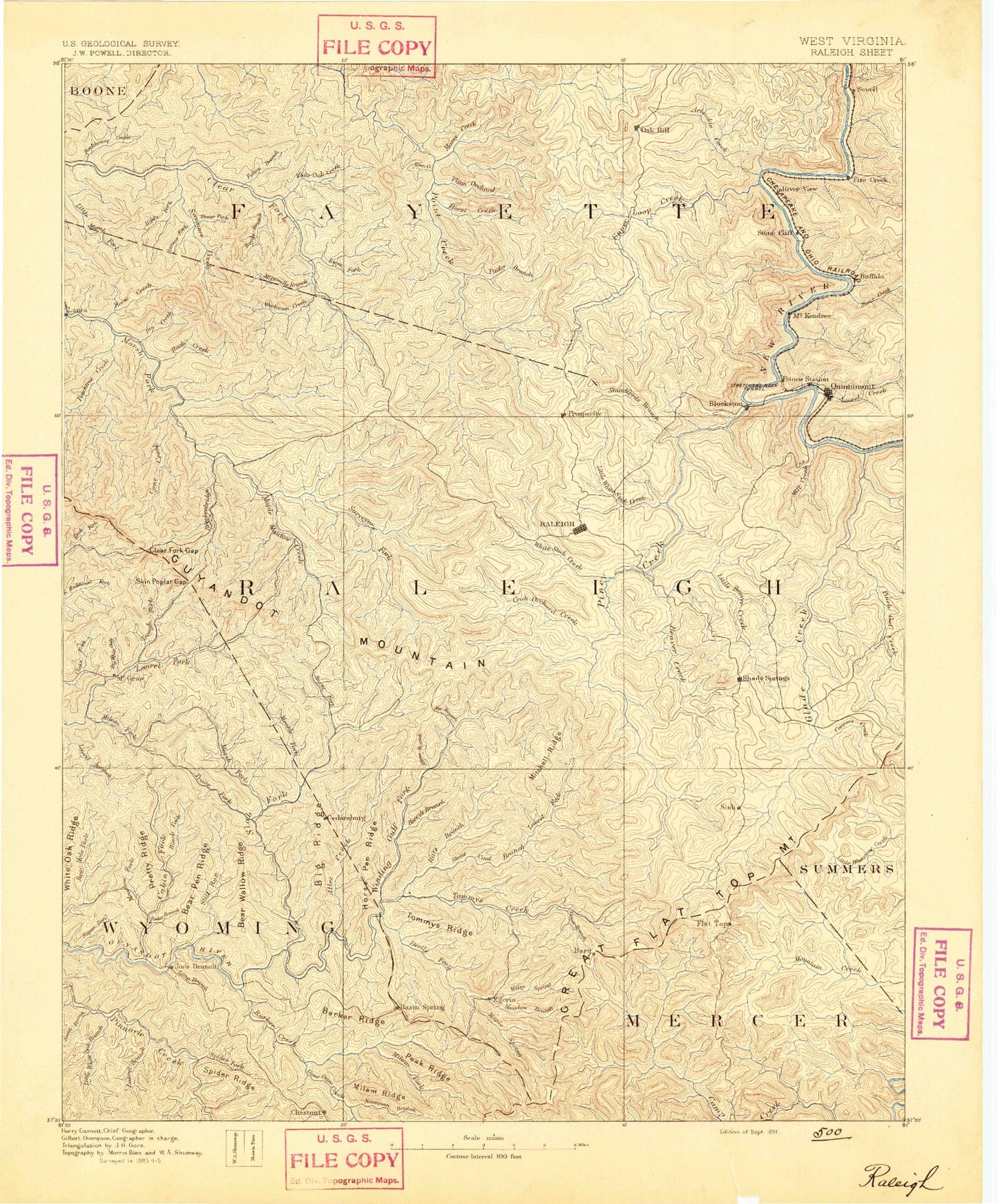
Historic 1891 Raleigh West Virginia 30'x30' Topo Map
Couldn't load pickup availability
Historical USGS topographic map of Raleigh in the state of West Virginia. Scale: 1:125000. Print size: 17" x 24"
This map was published in 1891 and is in the following counties: Boone, Fayette, Kanawha, Mercer, Raleigh, Summers, Wyoming.
The map contains contour lines, roads, rivers, towns, streams, and lakes. Printed on high-quality waterproof paper with UV fade-resistant inks.
Contains the following named places: Millers Fork, Acord Ridge, Adkins Branch, Alderson Branch, Allen Creek, Ameagle, Amigo, Arbuckle Creek, Arnold Branch, Austin Hollow, Bacon Hollow, Bailey Branch, Barkers Creek, Barkers Ridge, Barn, Barren Branch, Basham Branch, Basin, Batoff Creek, Batoff Mountain, Bear Creek, Bear Fork, Bear Hollow, Bearpen Branch, Bearwallow Ridge, Bearwallow Ridge, Beaver Creek, Beaverpond Branch, Bee Branch, Bee Branch, Bee Branch, Beech Bottom Branch, Beetree Branch, Beetree Branch, Bend Branch, Berry Branch, Besoco, Beury Mountain, Big Branch, Big Branch, Big Fork, Big Hollow, Big Hollow, Big Ridge, Big Stoney Creek, Bill Branch, Bills Branch, Bishop Fork, Black Fork, Blackhorn Branch, Blake Hollow, Blue Jay 6, Blue Jay Lake, Bluff Fork, Bluff Ridge, Bobs Fork, Bower Branch, Bowyer Creek, Boyd Branch, Boyd Branch, Boyd Branch Knob, Bragg Branch, Brammer Branch, Breckenridge Creek, Bridge Branch, Brushy Fork, Brushy Gap, Brushy Ridge, Buck Branch, Buck Fork, Buffalo Creek, Buffalo Fork, Burnt Fork, Burnt Ridge, Cabin Creek, Cabin Creek Ridge, Camp Branch, Camp Creek, Camp Creek State Forest, Canterberry Branch, Cassidy Branch, Castle, Cedar Branch, Cedar Branch, Cedar Creek, Cherry Creek, Chestnut Flat, Chestnut Flat Mountain, Chestnut Ridge, Clark Branch, Clay Branch, Claypool Hollow, Clays Branch, Clays Branch, Clear Creek, Clear Fork Gap, Coal River Mountain, Colcord, Comer Branch, Cool Ridge, Cooper Creek, Copperhead Branch, Corinne, Cove Creek, Crab Orchard, Crab Orchard Creek, Cranberry Creek, Crooked Run, Crow, Cub Branch, Culvert Hollow, Cyclone Hollow, Daniels, Dark Hollow, Davis Branch, Davis Fork, Devils Backbone, Devils Fork, Dickens Branch, Dillon Branch, Dingess Branch, Dixon Branch, Dixons Branch, Doris Branch, Dorothy, Dothan, Dow Fork, Dowdy Bluff, Dowdy Creek, Drews Creek, Dry Creek, Dry Creek, Dunloup Creek, Dustlick Creek, Eccles, Ellison Ridge, Ephraim Creek, Ewing Fork, Exhibition Mine, Farley Branch, Farley Branch, Farley Creek, Farley Ridge, Fat Creek, Fire Creek, Fitzpatrick Park, Flat Branch, Flat Top, Fork Ridge, Franks Fork, Fulton Creek, Garden Ground Mountain, Gardner Branch, George Branch, Georges Branch, Ghent, Gibson Branch, Glade Branch, Glade Creek, Glade Creek Reservoir, Glade Fork, Glen Gap, Goode Branch, Goode Creek, Gooney Otter Creek, Grandview, Grave Fork, Green Ridge, Griffith Branch, Guyan Ridge, Guyandotte Mountain, Halsey Branch, Hamilton Branch, Harper Branch, Harvey, Haystack Mountain, Hecks Knob, Hickory Branch, Hickory Branch, Hickory Branch, High Coal, Highland Mountain, Hilltop, Horse Creek, Horse Creek, Horse Creek, Horsepen Branch, Horsepen Ridge, Hotchkiss, Indian Ridge, Irish Lick Knob, Ivy Ridge, Jackson Branch, Jehu Branch, Jenny Branch, Jenny Gap, Jims Branch, Jims Branch, Joe Branch, Joes Ridge, Kates Branch, Kayford Mountain, Keaton Branch, Kelly Branch, Killarney, Knob Branch, Knob Fork, Lambert Branch, Lampkin Branch, Laurel Branch, Laurel Branch, Laurel Branch, Laurel Branch, Laurel Branch, Laurel Creek, Laurel Creek, Laurel Creek, Laurel Run, Lee, Left Fork Allen Creek, Left Fork Beaver Creek, Left Fork White Oak Creek, Lefthand Fork Bluff Fork, Lefthand Fork Cooper Creek, Lefthand Fork Paint Creek, Lefthand Fork Tommy Creek, Lem Fork, Lewis Fork, Lick Branch, Lick Branch, Lick Fork, Lick Fork Ridge, Lick Hollow, Lick Run, Little Beaver Creek, Little Beaver Creek