MyTopo
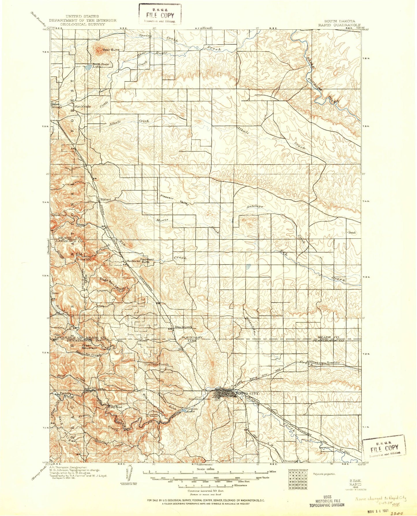
Historic 1898 Rapid South Dakota 30'x30' Topo Map
Couldn't load pickup availability
Historical USGS topographic map of Rapid in the state of South Dakota. Scale: 1:125000. Print size: 17" x 24"
This map was published in 1898 and is in the following counties: Lawrence, Meade, Pennington.
The map contains contour lines, roads, rivers, towns, streams, and lakes. Printed on high-quality waterproof paper with UV fade-resistant inks.
Contains the following named places: Bear Butte Lake, Bear Butte National Wildlife Refuge, Box Elder, College Park, Cottle Creek, Cyclone Ditch, Dinosaur Park, Dry Creek, H O Siding, Halley Park, Hangman Hill, Hawthorne Ditch, Iowa Ditch, Murphy Ditch, South Side Ditch, Sweet Gulch, Rapid Valley, Northgate Shopping Center, North Rapid Shopping Center, Robbinsdale Shopping Center, South Town Mall, Villa Ranchero Shopping Center, Rushmore Mall, Bear Butte, Bend, Murphy, Arrowhead Country Club, Bald Hills, Bald Mountain, Beatty Gulch, Beaver Gulch, Big Bend, Black Hills Kennel Club, Blackhawk Creek, Bogus Jim Creek, Boone Draw, Breakneck Gulch, Brush Creek, Bulldog Gulch, Buzzards Roost, Camp Rapid, Canyon Lake, Chimney Canyon, Cleghorn Canyon, Commissary Point, Custer Gulch, Dark Canyon, Dalton Lake, Deadman Gulch, Deer Creek, Erskine Gulch, Estes Creek, Forbes Gulch, Gold Standard Gulch, Gossage Memorial, Green Mountain, Hall Park, Hat Mountain, Hisega, Jim Creek, Little Elk Canyon, Little Elk Creek, Lone Tree Ditch, Loveland Canyon, McCurdy Gulch, Meadowbrook Golf Course, Middle Bogus Jim Creek, Norris Peak, North Bogus Jim Creek, Pactola Dam, Piedmont Butte, Pleasant Valley Creek, Powerhouse Gulch, Prairie Creek, Priest Canyon, Red Gate, Schaeferville, Shanks Gulch, Sioux Park, South Bogus Jim Creek, South Branch Prairie Creek, South Canyon, South Stagebarn Canyon, South Victoria Creek, Spring Creek, Stagebarn Canyon, Stagebarn Ridge, Steamboat Rock, Syndicate Gulch, Tamarack Gulch, Thrall Mountain, Thunderhead Falls Tunnel, Tilford, Tilford Gulch, Tomaha Camp, Tomaha Point, Turkey Hill, Twin Sisters, Victoria Creek, Victoria Dam, Waite Gulch, Wards Canyon, Wheaton College Summer Camp, White Gate, Wild Irishman Gulch, Canyon Lake Dam, Baken Park Shopping Center, Red Dale Gulch Dam, Red Dale Gulch Reservoir, Pactola Forest Service Facility, Pactola Point Picnic Area, Pactola Visitor Center, Dalton Campground, Streamboat Rock Picnic Area, Custer Gap, Presbyterian Church Camp, Wildwood Addition, Arrowhead Estates, Ridgeland Heights, South Canyon Country Estates, Sioux Village, Thunderbird Homes Addition, Twilight Hills Addition, Clarkson Addition, Blackhawk, Camp Columbus, Costello Point, Cottonwood Draw, Elm Creek, Fourmile Creek, Lone Tree Creek, McGee, Morris Creek, Piedmont, Rapid City, Marvin Reinhold Dam Number 1, Prairie View Farms Dam Number 1, Johnson Siding, Bear Butte, Lakota Homes, Cowboy Hill, Perrin Mountain, Placerville Camp, Thunderhead Falls, City of Box Elder, City of Rapid City, Unorganized Territory of Southwest Meade, City of Sturgis, Township of Rapid, Township of Pactola, Black Hills Maze, Lazy J RV Park and Campground, LaCroix Links Golf Course, The Ranch Amusement Park, Robbinsdale Park, Wilson Park, Dahl Fine Arts Center, Rapid City KOA, Rapid City Fairgrounds, Roosevelt Park, Executive Golf Course, Berry Patch Campground, Haines Station Shopping Center, Canyon Lake Park, Lake Park Campground, Camp Rapid, Baken Park Shopping Center, Storybook Island, Cleghorn Springs Fish Hatchery, Mount Wheaton, Ashland Heights, Green Valley, Colonial Pine Hills, Summerset, City of Summerset, City of Piedmont, O'Harra Stadium, Dunham Field, Floyd Fitzgerald Stadium, Dinosaur Park, Storybook Island, Buffalo Chip, Town of Buffalo Chip, Wonderland Homes