MyTopo
Historic 1903 Rathdrum Idaho 30'x30' Topo Map
Couldn't load pickup availability
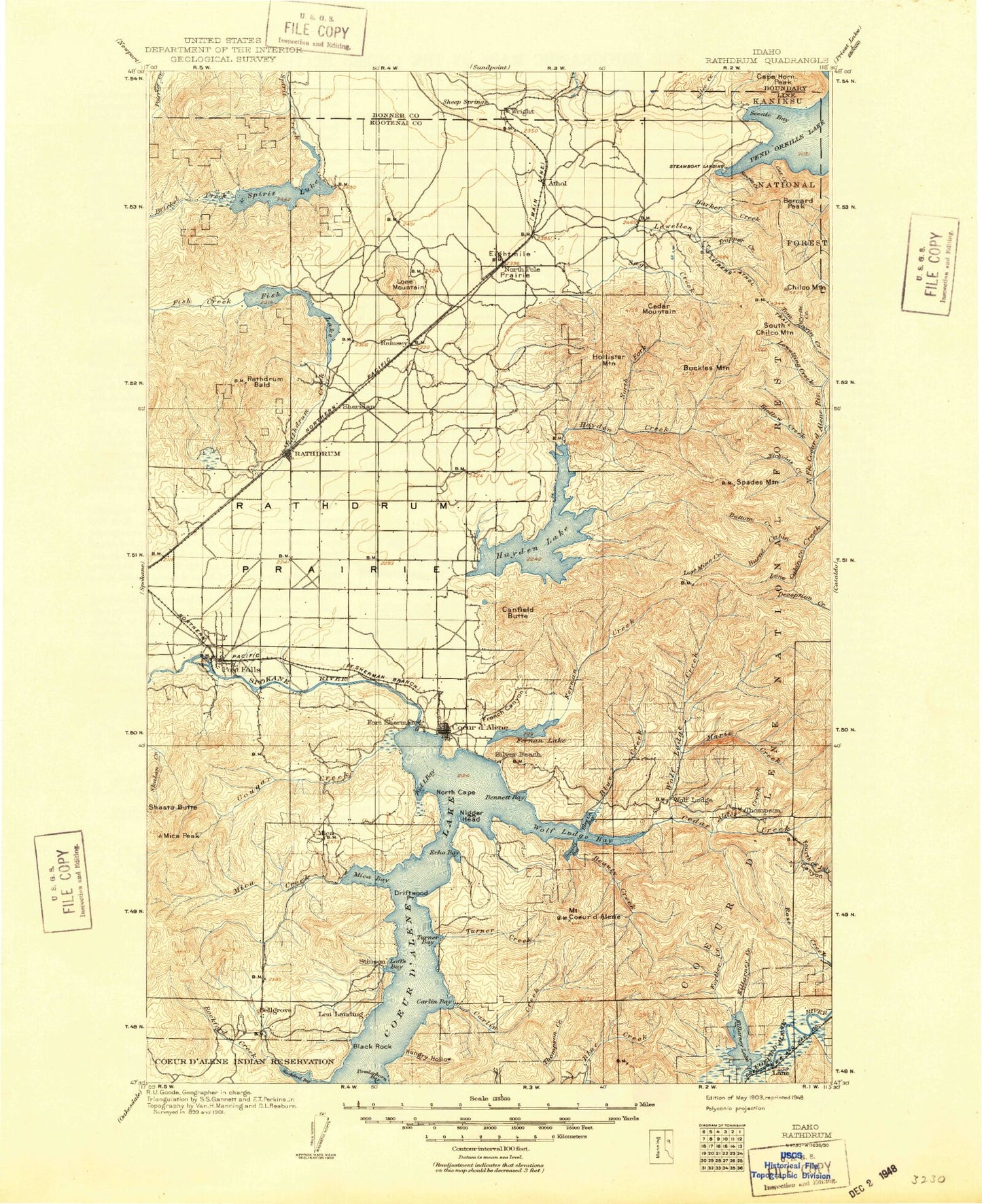
Historical USGS topographic map of Rathdrum in the state of Idaho. Scale: 1:125000. Print size: 17" x 24"
This map was published in 1903 and is in the following counties: Bonner, Kootenai.
The map contains contour lines, roads, rivers, towns, streams, and lakes. Printed on high-quality waterproof paper with UV fade-resistant inks.
Contains the following named places: Bellgrove Creek, Birch Creek, Black Bay, Blister Rust Creek, Blossom Mountain, Breakfast Creek, Butterworth Draw, Cabin Creek, Cherry Creek, Cloverleaf Grange, Corbin Park, Dinner Creek, Ford Rock, Killarney Lake, Lamb Creek, Lenz Creek, McGuires, Mokins Bay, North Cape, North Fork Cougar Creek, North Fork Mica Creek, Rockford Bay, Fighting Creek, Rodney Draw, Ross Point, Shasta Butte, South Fork Mica Creek, Strong Draw, Twin Bridge Creek, Twin Peaks, West Fork Birch Creek, Grand Junction, Deerfoot Ridge, Alder Creek, Armstrong Creek, Athol, Avondale Lake, Badger Mountain, Barker Creek, Barney Creek, Bayview Creek, Beauty Bay, Beauty Creek, Beaver Creek, Belmont, Bennett Bay, Bernard Peak, Bernard Point, Berven Bay, Birch Ridge, Black Bay, Black Rock, Black Rock Bay, Blackrock Gulch, Blackwell Island, Blackwell Point, Blue Creek, Blue Creek Bay, Blue Grouse Creek, Blue Rock Creek, Bottom Creek, Bozanta Tavern Bay, Bradbury Gulch, Bradbury Mine, Buckles Creek, Buckles Mountain, Bunco Corners, Burnt Cabin Mine, Burton Creek, Camp Easton, Camp Mivoden, Canyon Fork, Cardin Creek, Caribou Creek, Caribou Mine, Carill Peak, Carlin Bay, Carlin Creek, Carlin Grange, Carrill Creek, Casco Bay, Cat Creek, Cathcart Creek, Cedar Creek, Cellar Point, Chatfield Creek, Chicken Point, Chilco Creek, Chilco Mountain, Chinese Gulch, Clark Point, Coeur d'Alene, Colburn Creek, Commonwealth Mine, Conie Creek, Coopers Bay, Corbin Junction, Corner Creek, Cottonwood Creek, Cottonwood Peak, Cougar Bay, Cougar Creek, Cramps Bay, Crescent Bay, Danby Ridge, Dandy Mine, Delcardo Bay, Delcardo Creek, Driftwood Point, Dry Gulch, East Fork Hayden Creek, East Fork Hudlow Creek, East Greenacres Main Ditch, Echo Bay, Echo Bay, Eightmile Prairie, Eisenhour Ridge, Elk Mountain, English Point, Evernade Point, Falls Creek, Farmers Union, Farragut State Park, Fernan Creek, Fernan Lake, Fish Creek, Folsom Ridge, Fortier Creek, French Gulch, George Creek, Gotham Bay, Green Creek, Half Mile Creek, Half Round Bay, Hamburg Creek, Happy Cove, Harbor Island, Harrison Creek, Haycrop, Hayden Creek, Hells Canyon, Hidden Valley, Hogback Ridge, Holiday Creek, Hollister Creek, Honeysuckle Bay, Honeysuckle Beach, Howell Gulch, Huckleberry Mountain, Hudlow Camp, Hudlow Creek, Hudlow Mountain, Hudlow Saddle, Hungry Hollow, Idlewilde Bay, Jim Creek, Kelly Mountain, Kid Creek, Kid Island, Kid Island Bay, Killarney Creek, Lancaster Creek, Lane Creek, Lees Point, Lewellen Creek, Lewelling Creek, Line Creek, Little Creek, Lone Cabin Creek, Lonesome Creek, Lost Creek, Lost Mine Creek, Lyle Creek, Marie Creek, Martin Bay, McDonald Point, McGinnis Creek, McLeans Bay, McLeans Creek, Mica, Mica Bay, Mica Creek, Mica Flats, Middle Fork Hudlow Creek, Miller Creek, Mokins Bay Campground, Mokins Creek, Mokins Slough, Montford Creek, Moscow Bay, Mountain Tree Historic Site, Nelson Canyon, Nettleton Gulch, Nicholas Creek, Nilsen Creek, North Creek, North Fork Hayden Creek, North Fork Sage Creek, North Pole, O'Rourke Bay, Old Doe Draw, Old Maid Creek, Onowa Creek, Phantom Creek, Pilot Rock Sandpoint, Pleasant Creek, Preston Beach, Pyrite Creek, Rathdrum Creek, Rathdrum Mountain, Rathdrum Prairie, Reserve Creek, Ridge Creek, Rondo Gulch, Round Mountain, Roush Creek, Rutherford Gulch, Sage Creek, Sage Creek Saddle, Salee Creek, Sanders Beach, Sawpit Creek, Scenic Bay, Scenic Lodge, Scott Creek, Searchlight Creek, Seventy-Five Creek, Shamrock Creek, Shamrock Mine, Shove Creek, Silver Beach, Skinner Bay, Skitwish Creek, Smith Gulch, South Chilco Mountain, South Fork Cedar Creek