MyTopo
Historic 1904 Republic Washington 30'x30' Topo Map
Couldn't load pickup availability
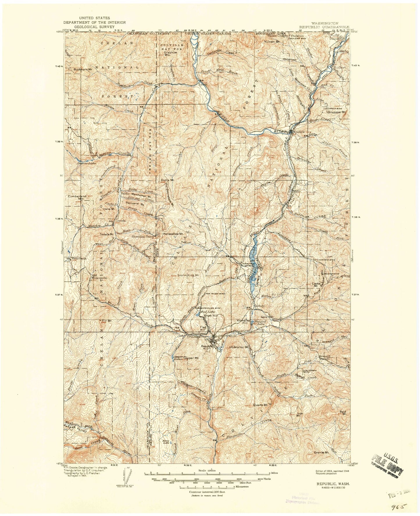
Historical USGS topographic map of Republic in the state of Washington. Scale: 1:125000. Print size: 18" x 24"
This map was published in 1904 and is in the following counties: Ferry, Okanogan.
The map contains contour lines, roads, rivers, towns, streams, and lakes. Printed on high-quality waterproof paper with UV fade-resistant inks.
Contains the following named places: Aeneas, Aeneas Creek, Alkali Creek, Art Creek, Bacon Creek, Bald Mountain, Bald Peak, Bamber Creek, Bamber Mountain, Barrett Butte, Barrett Creek, Bat Canyon, Bear Mountain, Bear Trap Canyon, Beaver Creek, Beaver Lake, Belcher Mountain, Beth Lake, Bodie, Bodie Creek, Bodie Mountain, Bodie Mountain Trail, Bodie Tonata Creek Trail, Box Canyon, Bracken Creek, Brown Mountain, Buckhorn Mountain, Lake Butte, Cache Creek, California Mine, Camel Back, Camel Creek, Catherine Creek, Cedar Creek, Clackamas Mountain, Cobey Creek, Coco Mountain, Coogan Creek, Cooke Mountain, Copper Lakes, Copper Mountain, Cornell Butte, Corner Butte, Cottonwood Creek, Cougar Creek, Cougar Mountain, Cumberland Creek, Cumberland Mountain, Curlew, Curlew Creek, Curlew Lake, Danville, Day Creek, Deep Creek, Denney Trail, Drummer Mountain, Eagle Rock, East Fork Cougar Creek, Edds Mountain, Mount Elizabeth, Emanuel Creek, Empire Creek, Empire Drive Trail, Empire Lake, Fawns Mill Trail, Ferry, Ferry Lake, Ferry Lake Trail, Fir Creek, Fir Mountain, Fire Mountain, Fish Lake, Flag Hill Mine, Franson Peak, Gardner Creek, Gibraltar Mountain, Gilg Canyon, Giveout Creek, Gold Axe Camp, Gold Hill, Golden Harvest Creek, Golden Harvest Trail, Goodrich Trail, Gooseberry Meadow, Goosmus Creek, Granite Creek, Granite Mountain, Granite Mountain, Graphite Creek, Graphite Mountain, Hardscrabble Mountain, Harvard Mountain, Harvey Creek, Henry Creek, Herron Creek, Horseshoe Mountain, Irene Mountain, Iron Mountain, July Creek, Karamin, Kelly Mine, Kelly Mountain, Klondike Mountain, Knob Hill Mine, Koepke Canyon, LaFleur Creek, Lambert Creek, Laws Trail, Little Goosmus Creek, Little Vulcan Mountain, Lone Ranch Creek, Long Alec Creek, Lost Creek, Lundimo Meadows, Lyman Lake, Magnetic Mine, Malo, Manhattan Mountain, Maple Creek, Maple Mountain, Marias Creek, Marias Creek Trail, McMann Creek, Meadow Creek, Middle Fork O'Brien Creek, Middle Fork Sanpoil River, Millard Creek, Mires Creek, Mud Lake, Murphy Hill, Nicholson Creek, Ninemile Creek, North Fork Beaver Creek, North Fork Day Creek, North Fork Goosmus Creek, North Fork Granite Creek, North Fork O'Brien Creek, North Fork Saint Peter Creek, North Fork Sanpoil River, North Fork Trout Creek, O'Brien Creek, Ogle Creek, Old Sheridan Mine, Old Toroda, Old Wauconda, Pollard, Quartz Mountain, Rabbit Creek, Refrigerator Canyon, Republic, Resner Canyon, Rincom Creek, Roosevelt Camp, Saint Peter Creek, Saint Peter Flat, Sanpoil Lake, Scatter Creek, Shasket Creek, Sheep Mountain, Shovel Creek, Silver Bell Mine, Skiffington Creek, Snow Peak, Snyder Trail, South Fork Beaver Creek, South Fork Day Creek, South Fork Ninemile Creek, South Fork O'Brien Creek, South Fork Saint Peter Creek, South Fork Sanpoil River, South Fork Trout Creek, Storm King Mountain, Storm King Trail, Sunset Creek, Swan Butte, Swan Lake, Sweat Creek, Tenas Mary Creek, Tenmile Creek, Tenmile Trail, Tom Thumb Mine, Tonasket Creek, Tonata Creek, Torboy, Toroda, Toroda Creek, Toroda Mountain, Trout Creek, Turner Creek, Vaughn Creek, Vulcan Lookout, Vulcan Mountain, Walker Creek, Mount Washington, Wauconda Summit, West Deer Creek, West Fork Cedar Creek, West Fork Cougar Creek, West Fork Granite Creek, West Fork Trout Creek, Westphal Gulch, White Creek, Thirteenmile Mountain, Curlew Lake State Park, Cow Camp, Ranald MacDonald Historical Site, Ward Lake, Malo Lake, Hurlburt, C M Pardey Ranch, Curlew Lake Campground, Curlew Civilian Conservation Center, Wheaton Lake, Swan Lake Campground, Ferry Lake Campground, Atchison Mill, Beth Lake Campground, Beaver Lake Campground, Cow Camp Corral, Sweat Creek Campground, Mosquito Lake, Wiseman Island, Zipphel Island, Fishermans Cove, Dollar Mountain Burn Game Preserve, O'Connor Canyon, Curlew Administration Site, Maple Mountain Trail, Beth Lake Dam, Day Mine Tailings Pond Dam, Curlew Lake Dam, Curlew Division, Republic Division, City of Republic, Torboy Transfer Station Solid Waste Facility, Kettle River Quarry