MyTopo
Historic 1905 Richland Wisconsin 30'x30' Topo Map
Couldn't load pickup availability
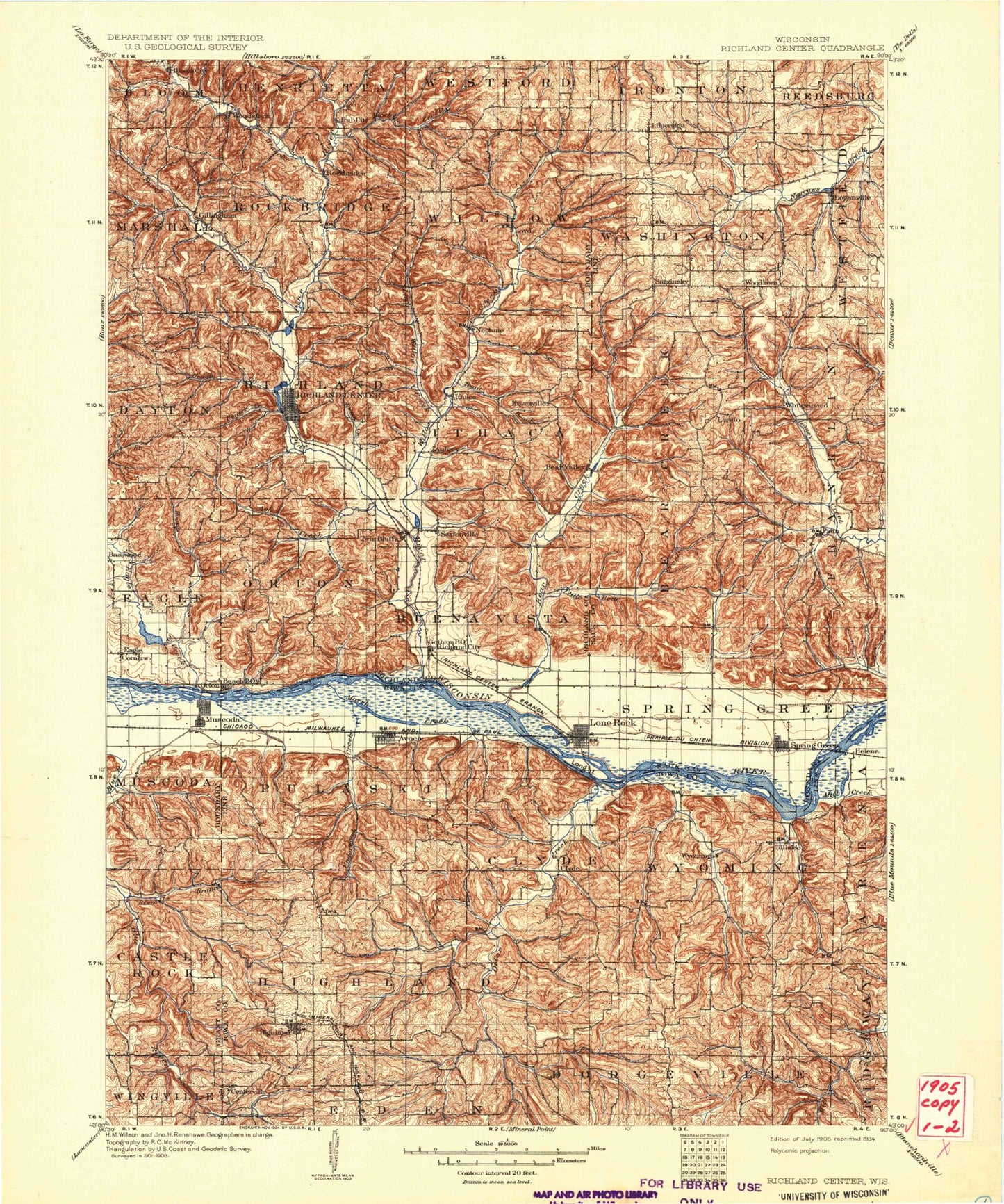
Historical USGS topographic map of Richland in the state of Wisconsin. Scale: 1:125000. Print size: 17" x 24"
This map was published in 1905 and is in the following counties: Grant, Iowa, Richland, Sauk.
The map contains contour lines, roads, rivers, towns, streams, and lakes. Printed on high-quality waterproof paper with UV fade-resistant inks.
Contains the following named places: Avoca, Avoca Lake, Badger Hollow, Bear Creek, Bear Valley, Big Cat Slough, Big Hollow, Big Rock, Big Rock Branch, Big Spring Branch, Bigelow Hill, Bloom City, Blue Hole, Bogus Bluff, Bohemian Ridge, Bomkamp Ridge, Brush Creek, Bunker Hill, Center Creek, Chicken Ridge, Cox Hollow, Cox Hollow Lake, Cruson Slough, Cynthia Slough, Day Rock, Deer Island, Deer Shelter Rock, Dixon Lake, Dry Dog Ridge, Dunbar Hill, Eagle Corners, Ela Valley, Fancy Creek, Farmers Ridge, Flint Creek, Four Springs Hollow, Gault Hollow, Goodwiler Lake, Gotham, Helena, Hickory Flat, High Bank Island, Highland, Hill Point Creek, Hill Slough, Hoosier Hollow, Horse Creek, Hunter Hollow, Hutter Slough, Hynek Hollow, Indian Creek, Jones Slough, Jones Valley, Kendal Lake, Lime Ridge, Little Bear Creek, Loganville, Lone Rock, Long Island, Long Island, Long Lake, Long Lake, Lost Hollow, Lowery Creek, Loyd, Maiden Rock, Marsh Creek, Marshall Creek, McClary Island, Metcalf Island, Mill Creek, Mill Creek, Miller Hollow, Morrey Creek, Muscoda, Muscoda Island, Norton Slough, Norway Hollow, Oak Ridge, Orion, Otter Creek, Penn Hollow, Percussion Rock, Pine Hill, Plain, Pleasant Ridge, Pleasant Valley, Pompey Pillar, Pumpkin Hollow, Red Oak Ridge, Riverview Ridge, Robin Hollow, Rocky Branch, Round Hole, Rush Creek, Sand Branch, Shannahan Valley, Sixmile Branch, Smith Hollow, Smoky Hollow, Sneed Creek, Spring Green, Spring Hill, Spring Valley, Spring Valley, Sugar Grove Valley, Sunny Ridge, Sunset Rock, Sweet Island, Tar Hollow, Tower Hill, Tower Hill State Park, Union Ridge, Wards Corners, West Branch Marshall Creek, Whites Slough, Wilson Creek, Wood Slough, Woodstock, Wyoming Valley, Yagers Hollow, Twin Valley Lake, Penn Hollow Creek, Strutt Creek, Paul Creek, Love Creek, Meudt Creek, Canyon Park Creek, Cutler Creek, Norway Hollow Creek, Smoky Hollow Creek, Dickinson Creek, Pompey Pillar Creek, Black Hawk Lake, Pengelly Creek, Lee Creek, Harker Creek, Norwegian Hollow Creek, McCarville Creek, Marble Creek, John Hill Creek, Badger Hollow Creek, Bronson Creek, Pier Spring Creek, Halverson Lake, Basswood, Centerville, Clyde, Gillingham, Keyesville, Loreta, Pleasant Ridge, Sandusky, Wyoming, Hill Point, Ash Creek, Aubrey, Buck Creek, Bunker Hill, Durst Hollow, Happy Hollow, Hawkins Creek, Hell Hollow, Hub City, Hulster Ridge, Ithaca, Jacquish Hollow, Little Willow Creek, Melancthon Creek, Nebraska Hollow, Neptune, North Buck Creek, Pine River, Pumpkin Hollow, Richland Center, Rockbridge, School Section Hollow, Sextonville, Simpson Hollow, Snake Creek, Soules Creek, South Buck Creek, Spring Creek, Twin Bluffs, West Branch Pine River, Wheat Hollow, Willow Creek, Misslich Creek, Johnston Creek, Iowa County, Richland County, Governor Dodge State Park, Village of Avoca, Town of Bear Creek, Town of Buena Vista, Town of Castle Rock, Town of Clyde, Town of Dayton, Town of Dodgeville, Town of Eagle, Town of Franklin, Village of Highland, Town of Highland, Town of Ithaca, Village of Lime Ridge, Village of Loganville, Village of Lone Rock, Town of Marshall, Village of Muscoda, Town of Muscoda, Town of Orion, Village of Plain, Town of Pulaski, Town of Richland, City of Richland Center, Town of Rockbridge, Village of Spring Green, Town of Spring Green, Town of Washington, Town of Westfield, Town of Willow, Town of Wyoming, Elephant Trunk Rock, Rockbridge, Cox Hollow Number One Dam, Cox Hollow Number 2 2WP1783 Dam, Twin Valley Lake 6.07, Blackhawk Lake Dam, Wright 3WR1787 Dam, Lower Taliesin Lake 12, Rodolf Dam, Balmoral Pond 94, Parfrey Dam, Richland Center Millpond 189, Twin Parks 3 2WP1780 Dam, 2 Reservoir