MyTopo
Historic 1892 Richmond Kentucky 30'x30' Topo Map
Couldn't load pickup availability
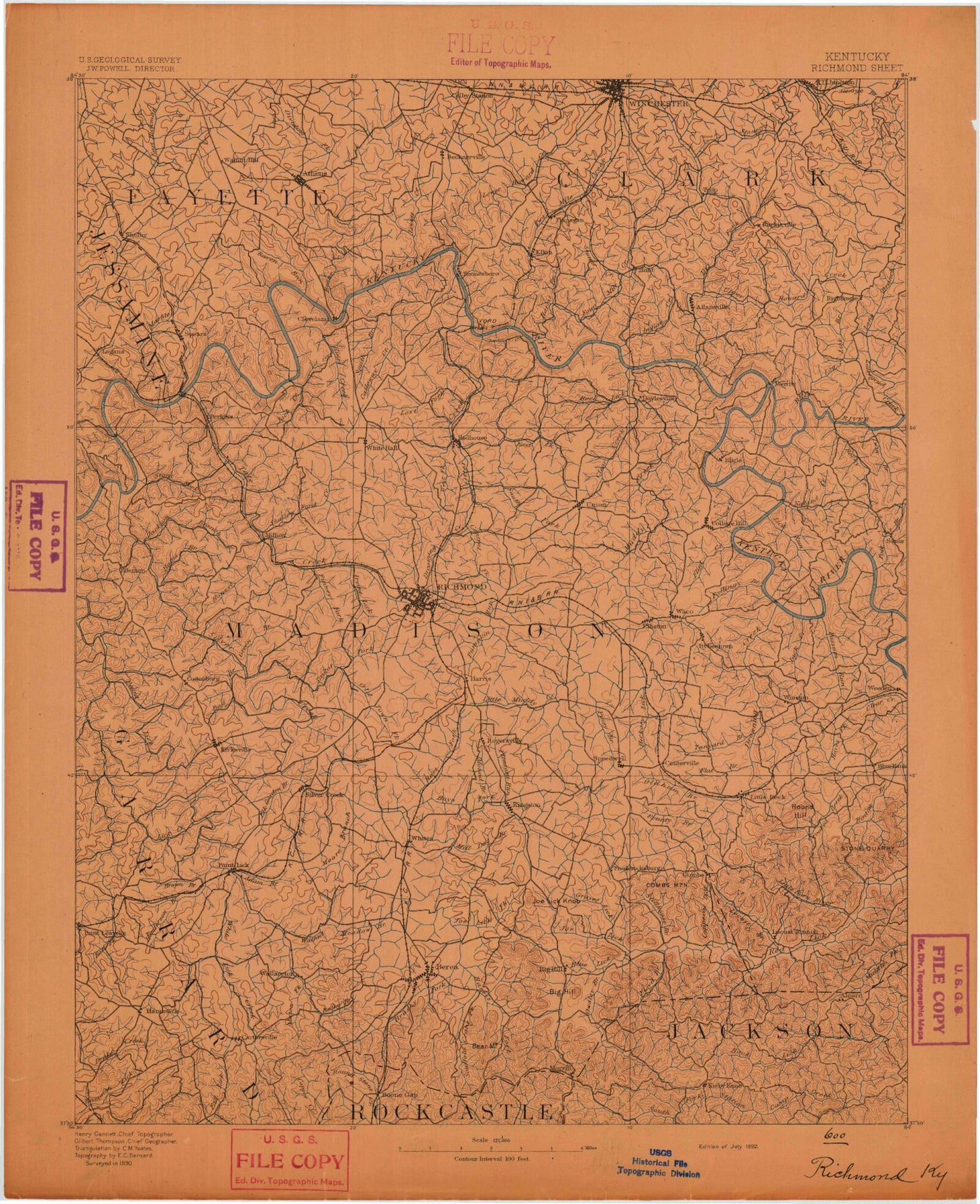
Historical USGS topographic map of Richmond in the state of Kentucky. Scale: 1:125000. Print size: 17" x 24"
This map was published in 1892 and is in the following counties: Clark, Estill, Fayette, Garrard, Jackson, Jessamine, Lincoln, Madison, Montgomery, Powell, Rockcastle.
The map contains contour lines, roads, rivers, towns, streams, and lakes. Printed on high-quality waterproof paper with UV fade-resistant inks.
Contains the following named places: Upper Howard Creek, Arlington, Athens, Back Creek, Baldwin, Ball Branch, Ballard Branch, Baughman Fork, Bear Mountain, Berea, Big Round Mountain, Black Branch, Blue Grass Camp, Blue Run, Boggs Fork, Bogie Branch, Boone Creek, Boone Gap, Broadus Branch, Brown Branch, Brushy Fork, Buffalo Creek, Buggytown, Bull Run, Bush Hollow, Butler Branch, Button Lick Knob, Bybee, Calloway Creek, Caney Branch, Caney Branch, Centerville, Cincinnati Branch, Clays Ferry, Clear Creek, Codell Lake, Colby Hills, Coletown, Conn Branch, Cotton Creek, Cow Creek, Crutcher Fork, Dead Horse Knob, Devils Backbone, Dog Branch, Dog Walk Branch, Dreaming Creek, Drowning Creek, Dry Branch, Dry Fork, Dry Ridge, Duck Branch, Dug Hill, Dumford Hollow, Dunbar Branch, Eagle Nest Hill, East Fork Back Creek, East Fork Fourmile Creek, East Fork Otter Creek, East Hickman, East Hickman Creek, Elk Garden Branch, Elk Lick Creek, Falling Branch, Farristown, Finney Fork, Flint Creek, Ford, Forest Grove, Fort Boonesboro State Park, Fourmile Creek, Frog Branch, Gilead Branch, Graveyard Hill, Green Fields Estates, Greens Branch, Hampton Manor, Hams Branch, Harris Branch, Harts Fork, Hedges, Henderson Branch, Hickory Lick, Hicks Branch, Hines Creek, Hinton Branch, Honest Branch, Hoys Fork, Indian Creek, Irvine Lick, Jacks Creek, Jackson Branch, Jolly Ridge, Jones Branch, Jones Creek, Judytown Branch, Kings Fork, Kingston, Kirksville, Lexington, Lick Run, Lily Mountain, Lisletown, Little Howard Creek, Little Muddy Creek, Little Round Mountain, Lock 9, Log Lick Creek, Logana, Long Branch, Long Branch, Long Branch, Long Branch, Long Hollow, Lost Fork, Lowell Branch, Lower Bend, Lower Howard Creek, Lulbegrud Creek, Lyndale, Marble Creek, Marsha Bottom, Mason Fork, Maupin Bend, Middletown, Moberly, Newby, Nihizertown, Noland Creek, Old Town Branch, Oldham Branch, Otter Creek, Paint Lick, Pea Ridge, Peter Mountain, Pilot View, Pine Ridge, Polecat Creek, Poosey Ridge, Possum Run, Preacher Estes Mountain, Pricetown, Puckett Lake, Raven Branch, Raven Run, Lake Reba, Reeds Crossing, Richmond, Rock Lick, Rocky Branch, Rocky Lick, Round Hill, Ruckerville, Sand Hill, Sand Hill, Schollsville, Shelby Branch, Silver Creek, Slate Lick, Smith Fork, South Fork Noland Creek, Southeastern Hills, Speedwell, Stoner Branch, Stony Fork, Stony Run, Tate Creek, Taylor Fork, Wilgreen Lake, Terrill, The Bend, The Forks, Thornsburg Bend, Tracy Branch, Tribble Branch, Trotting Ridge, Twin Creek, Twomile Creek, Union City, Valley View, Viny Fork, Waco, Walker Branch, Walker Branch, Wallaceton, Walnut Meadow Branch, Wesleyan Park, West Fork Back Creek, West Fork Lower Howard Creek, West Fork Otter Creek, West Fork Silver Creek, West Hickman Creek, Wheeler Branch, White Hall, White Lick Creek, Winchester, Winchester Reservoir, Winston, Woodward Creek, Welch Mountain, Agawam, Becknerville, Bloomingdale, Boone, Boonesborough, Brassfield, Caleast, Calloway Crossing, Cartersville, Colby, College Hill, Cottonburg, Cressy, Crow Valley, Cuzick, Doylesville, Duncanon, Edenton, Elkin, Elliston, Flanagan, Fox, Gainesway, Goffs Corner, Hackley, Happy Landing, Hargett, Hootentown, Hunt, Iron Mound, Jonestown, Locust Grove, Log Lick, Lowell, Manse, Million