
MyTopo
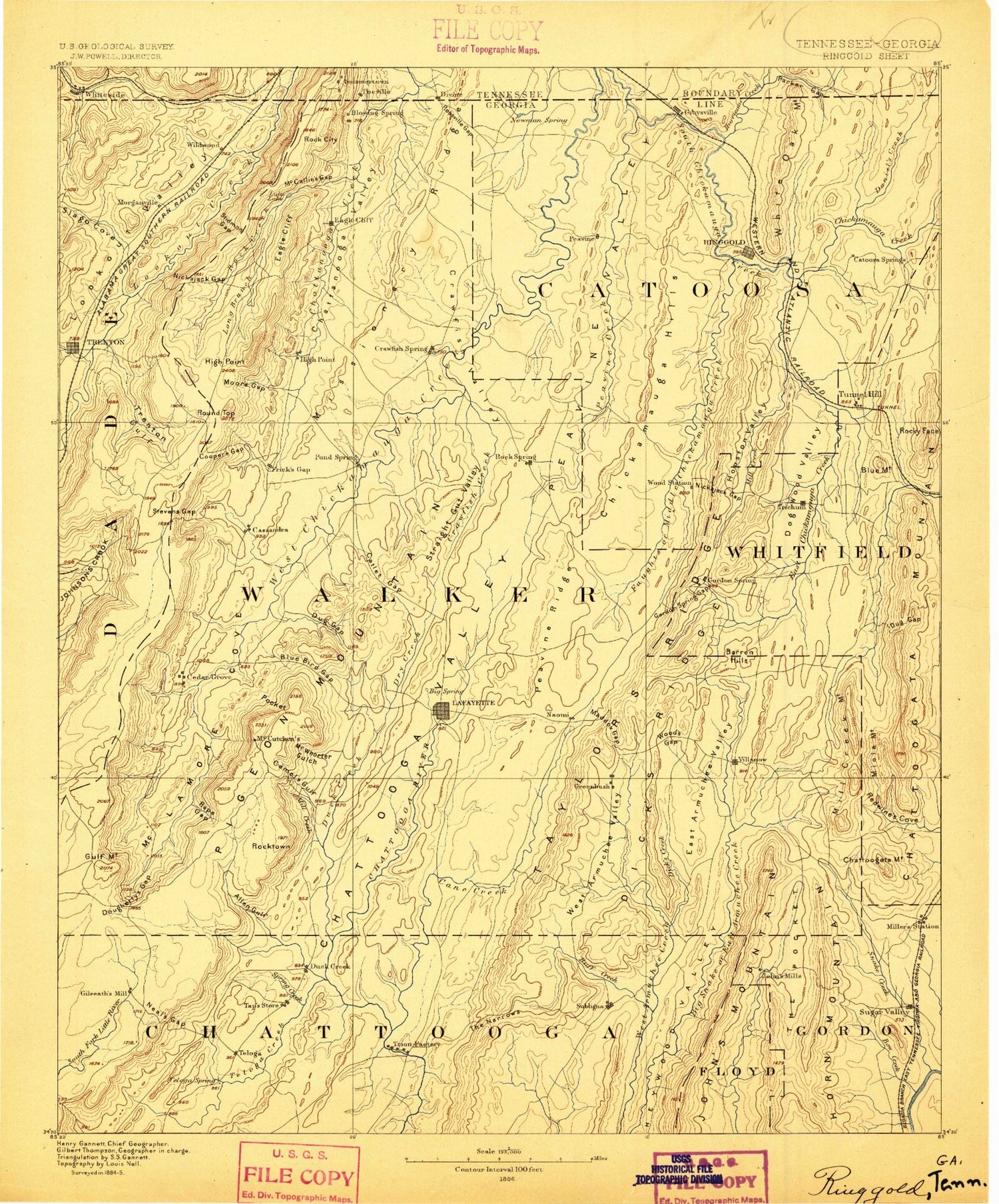
Historic 1886 Ringgold Georgia 30'x30' Topo Map
Couldn't load pickup availability
Historical USGS topographic map of Ringgold in the state of Georgia. Scale: 1:125000. Print size: 17" x 24"
This map was published in 1886 and is in the following counties: Catoosa, Chattooga, Dade, Floyd, Gordon, Hamilton, Marion, Walker, Whitfield.
The map contains contour lines, roads, rivers, towns, streams, and lakes. Printed on high-quality waterproof paper with UV fade-resistant inks.
Contains the following named places: Shinbone Ridge, Coke Oven Branch, Aiken Branch, Allen Creek, Allen Spring Gap, Allgood Branch, Anderson Gulf, Andrews Branch, Atwood Point, Back Valley Creek, Bailey Branch, Bear Creek, Big Spring Branch, Bird Hollow, Bluff Trail, Boatman Creek, Bradford Gap, Broom Branch, Brotherton Creek, Burnt Mill Valley, Camp Adahi, Camp Lookout, Chandler Hollow, Chelsea Creek, Chelsea Gulf, Cloudland, Cloudland Canyon State Park, Cloudland Canyon State Park, Coulter Branch, Crawfish Spring Lake, Crawfish Valley, Daniel Creek, Devils Cove, Dickson Lake, Double Hollow, Dougherty Gap, Dougherty Gulf, Dry Creek, Dry Creek, Dry Wash Branch, Dugan Point, Dyer Field, Dynamite Hollow, Egypt Hollow, Flatrock Point, Forester Gulch, Frady Gulf, Fuggett Branch, Gamble Branch, Gayton Gulf, Gilbert Lake, Gilreath Creek, Gordon Lake, Hall Branch, Hall Gap, Harp Ridge, Harper Branch, Harrisburg Gap, Hatfield Branch, Hawk Cliff, Hawkins Ridge, Henson Gulf, Hickman Gulf, High Point, High Point, High Rock, Hise Branch, Hise Gulf, Hogjowl Creek, Hogjowl Valley, Huckleberry Point, Ironco Hollow, Jack Branch, Jake Goodson Creek, Johnson Crook, Jones Gap, Kelly Field, Ketner Branch, Kirkis Gulf, LaFayette, Lawrence Gulf, Lee and Gordon Mill, Left Fork Coulter Branch, Little Mans Gulch, Long Branch, Long Cove, Long Hollow, Long Hollow, Lookout, Lookout Valley, Lula Falls, Lula Lake, Mahan Branch, McCallie Gap, McCallie Lake, McClain Branch, McCollum Branch, McFarland Gap, McKaig Gulf, McLemore Cove, McWhorter Gulf, Mill Creek, Mill Creek, Mill Creek, Miller Gap, Missionary Ridge, Missionary Ridge, Moore Branch, Moore Gap, Morrison Branch, Mud Creek, Murphy Hollow, Neal Gap, Neal Gulf, Nichols Hollow, Nickajack Gap, Owl Hollow, Paris Hollow, Payne Gap, Pittman Branch, Pocket Branch, Poe Field, Pope Creek, Possumtrot Branch, Powder Mill Branch, Price Branch, Pump Gulf, Rape Gap, Rock City Gardens, Rock Creek, Rocktown Branch, Rogers Branch, Roland Ridge, Rossville Gap, Sandy Hollow, Sawmill Branch, Shankle Branch, Shankle Ridge, Shaw Branch, Sims Spring Branch, Skyuka Trail, Slygo Ridge, Snodgrass Field, Sparger Gulf, Spring Garden, Squirrel Town Creek, Steven Gap, Stidmon Gap, Straight Gut Valley, Street Point, Strickland Branch, Sugar Camp Gulf, Tannery Gulf, Tarkiln Gap, The Hills, The Pocket, Town Creek, Town Creek, Trickum Branch, Tucker Branch, Tucker Branch Lake, Viniard Field, Voiles Creek, Walden Branch, Waterfall Branch, Wauhatchie Branch, Weathers Branch, West Brow Lake, Wheeler Branch, Wilson Ponds, Windy Gap, Wright Mineral Spring, Sharpe, Conley Bluff, Blue Spring, Noble, Stanfield Branch, Arnold Branch, Bailey Creek, Hampton Branch, Baugh Mountain, Bell Branch, Black Branch, Blue Spring Branch, Bow Creek, Broom Branch, Calhoun Gap, Camp Sidney Dew, Cane Creek, Carp Lake, Cat Creek, Catoosa Springs Branch, Catoosa Target Range, Chappel Creek, Cherokee Valley, Chetoogeta Mountain Tunnel, Clements Pond, Cobblestone Lake, Concord Creek, Cove Creek, Cove Gap, Dick Creek, Dogwood Valley, Dry Branch, Dry Creek, Dry Creek, Dry Creek Valley, Dry Valley, Duck Creek, Dug Gap, Duncan Park, East Armuchee Valley, East Chickamauga Creek, Furnace Creek, Furnace Valley, Gentry Gap, Goodson Bend, Gordon Spring Creek, Greenbush Branch, Hall Hollow, Harris Gap, Hawk Ridge, Hayes Branch, Hidden Creek Recreation Area, Hopkins Branch, Houston Branch, Houston Valley, Lake Howard, Hurricane Valley, Johns Mountain Wildlife Management Area, Lake Kathy, Keown Falls, Keown Falls Recreation Area, Kettle Branch, Kilpatrick Hollow, Little Chickamauga Creek


