MyTopo
Historic 1943 Roanoke Island North Carolina 30'x30' Topo Map
Couldn't load pickup availability
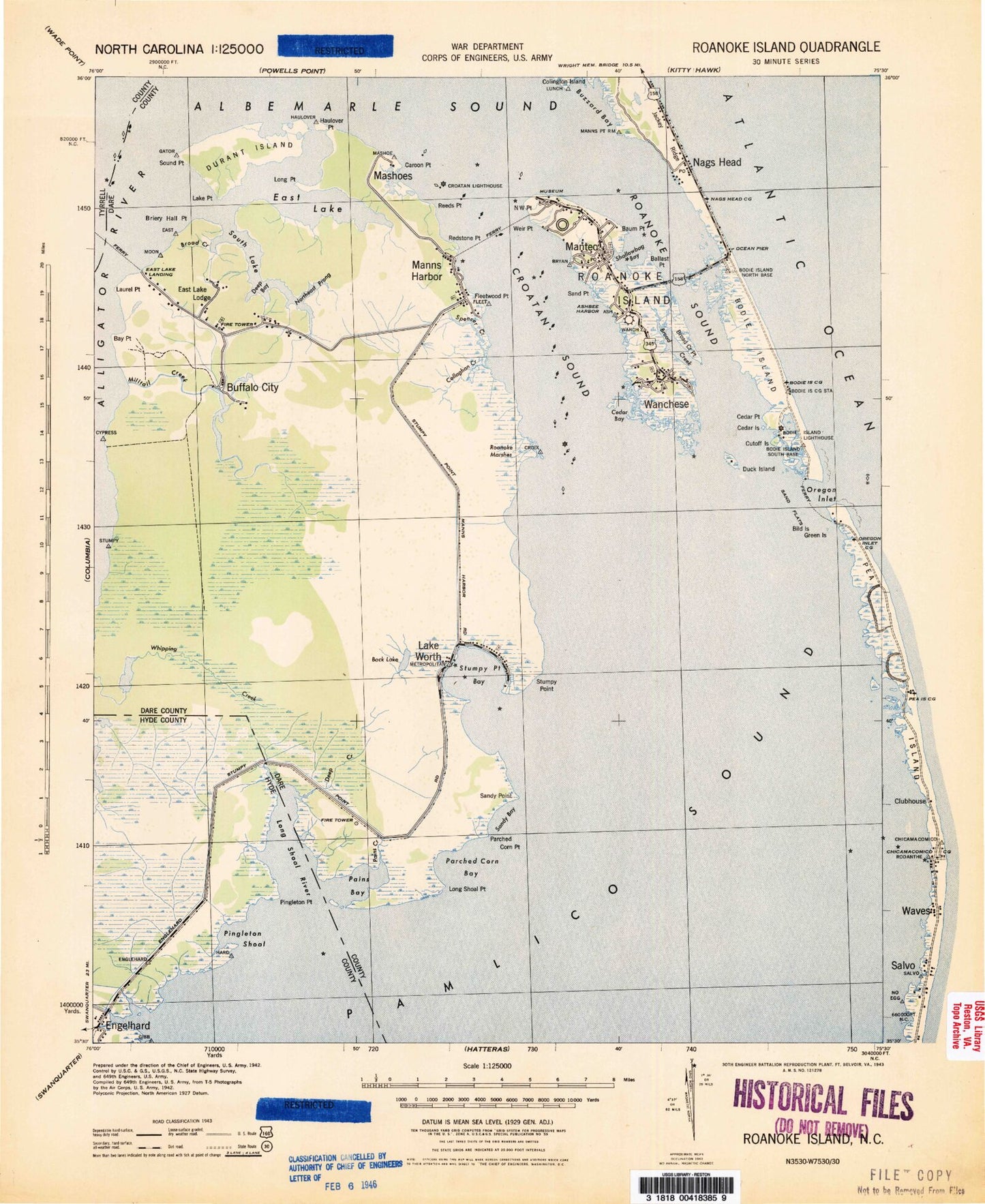
Historical USGS topographic map of Roanoke Island in the state of North Carolina. Scale: 1:125000. Print size: 18" x 24"
This map was published in 1943 and is in the following counties: Dare, Hyde, Tyrrell.
The map contains contour lines, roads, rivers, towns, streams, and lakes. Printed on high-quality waterproof paper with UV fade-resistant inks.
Contains the following named places: Alligator River, Ashbee Harbor, Back Lake, Ballast Point, Baum Creek, Baum Point, Bay Point, Bells Island, Berrys Bay, Big Penguin Island, Big Tim Island, Billys Ditch, Blossie Creek, Boat Bay, Bodie Island Clubhouse, Bodie Island Lighthouse, Boranges Point, Briery Hall Point, Broad Creek, Broad Creek, Broad Creek, Broad Creek Point, Buffalo City, Buzzard Bay, Buzzard Roost, Callaghan Creek, Caroon Point, Cedar Bush Bay, Cedar Island, Cedar Island, Cedar Point, Clark Creek, Cumberland Creek, Cut Through, Cut Through, Cypress Point, Davis Channel, Davis Pond, Deep Bay, Deep Creek, Deer Creek, Doughs Creek, Douglas Island, Drain Point, Duck Island, Durant Island, Eagle Nest Bay, Eagle Nest Point, East Lake, Engagement Hill, Fleetwood Point, Fort Raleigh National Historic Site, Gar Gut, Georges Creek, Gibbs Point, Goat Island, Goat Island Bay, Goat Island Point, Goose Island, Goose Island Point, Green Island Channel, Grun Island, Halfway Point, Haulover Point, Headquarters Island, Herring Shoal Island, Hog Island, Hog Island Creek, Hooker Gut, House Island, Jack Shoal, Jeanettes Pier, Jesse Shoal Point, Johns Creek, Juniper Swamp Point, Kazer Point, Kitty Creek, Lake Point, Liehue Gut, Lighthouse Bay, Little Penguin Island, Little Tim Island, Long Shoal Point, Long Stretch, Mann Point, Manns Harbor, Manns Harbor, Manteo, Manteo Well Field Site, Mashoes Marsh, Middle Ground, Mill Landing Creek, Milltail Creek, Motts Creek, Muddy Creek, Nags Head Island, Nags Head Woods, Ned Bees Point, North Point, Northeast Prong, Northwest Point, Off Island, Old Ferry Dock, Old House Channel, Old Point, Oregon Inlet, Oregon Inlet Channel, Otter Creek, Oyster Creek, Oyster Creek, Oyster Creek, Pains Bay, Pains Creek, Pains Point, Parched Corn Bay, Parched Corn Point, Pea Island Bay, Pea Island Creek, Pea Island Point, Peter Mashoes Creek, Pingleton Point, Pond Island, Poster Gut, Raccoon Point, Rawls Island, Redstone Point, Reeds Point, Roanoke Island, Roanoke Marsh, Roanoke Marshes Lighthouse, Roanoke Sound, Roanoke Sound Channel, Rockhall Creek, Sand Beach Creek, Sand Point, Sandy Bay, Sandy Point, Sandy Point, Sandy Point Shoal, Sandy Ridge, Sandy Ridge Gut, Sawyer Lake, Scarboro Creek, Shad Point, Shallowbag Bay, Skyco, Smith Creek, Smith Island, Sound Point, South Lake, South Point, Spencer Creek, Stumpy Point, Stumpy Point Bay, Terrapin Creek, Terrapin Creek Bay, Terrapin Creek Point, The Frying Pan, The Trench, Theoff Point, Tom Mann Creek, Tommy Hammock, Turn Basin, Walter Slough, Wanchese, Waupopin Creek, Weir Point, Whipping Creek Lake, Wild Boar Point, Jockey's Ridge State Park, Cape Hatteras Group Headquarters, Lindsay Warren Visitor Center, Oregon Inlet Fishing Center, Coquina Bench, Bodie Island Marshes, Nags Head Pier, Outer Banks Pier and Fishing Center, Ice Plant Island, Mashoes, Rawls Point, Whalebone Junction Information Station, Alligator River National Wildlife Refuge, Whalebone, Big Island, Billys Woods, Oregon Inlet Marina Convenience Store, Oregon Inlet Lifeboat Station, Bodie Island Visitor Center, Coquina Beach, Crab Claw Spit, Thomas Hariot Nature Trail, Elizabethan Gardens, Deep Ditch Point, Otis Cove, Bens Point, Blockade Shoal, Buzzard Point, Colington Island Shoal, Colington Cut, East Lake, East Lake Landing, Outer Banks Mall, Spence Creek, Hammock Ditch, Penguins Islands, Green Islands, Long Shoal, Black Hall Bay, Pork Point, Deep Wear Point, Scarboro Point, First Creeks, McKnights Ditch, Baumtown, Beach Land Landing, Bodie Island, California, Croatan Sound, Engelhard, Far Creek, Fort Raleigh City, Lake Neighborhood, Lake Worth, Mill Landing, Mother Vineyard, Nags Head, Seven Sisters, Sound Side, Stumpy Point, Sunny Side, Whalebone, Dare County, Township of Croatan, Township of East Lake, Township of Nags Head, Jockeys Ridge