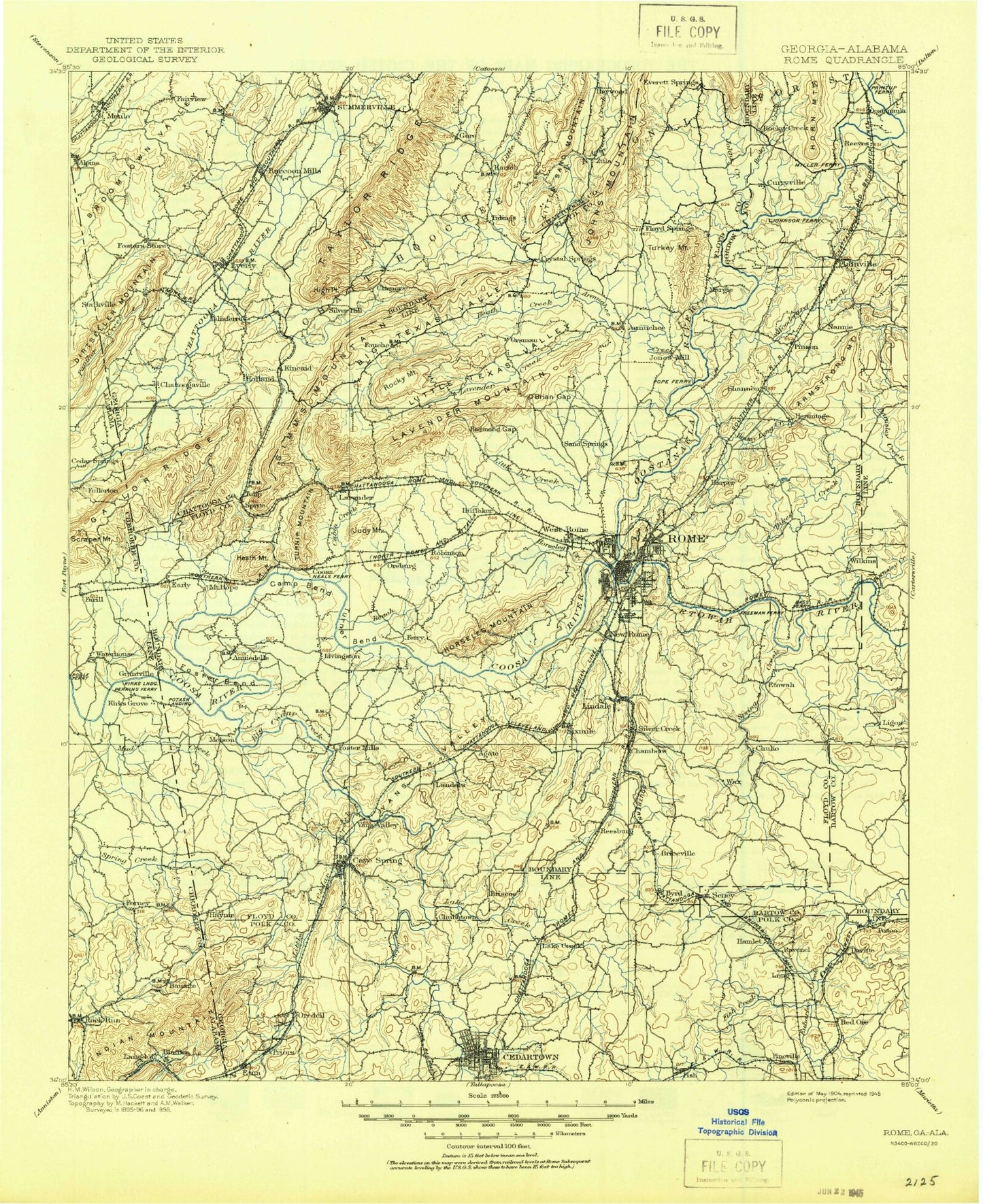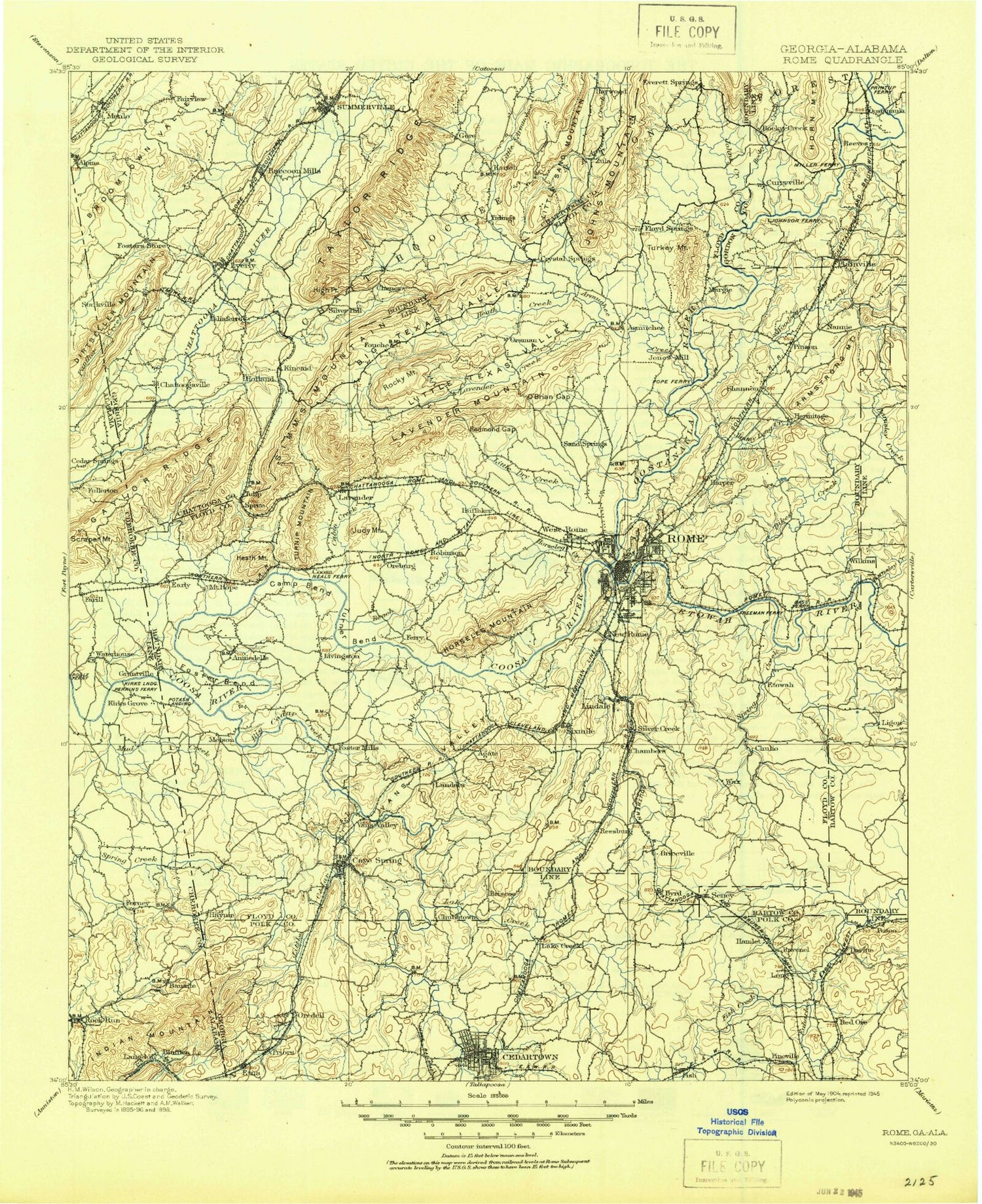
MyTopo
Historic 1904 Rome Georgia 30'x30' Topo Map
Couldn't load pickup availability
Historical USGS topographic map of Rome in the state of Georgia. Scale: 1:125000. Print size: 18" x 24"
This map was published in 1904 and is in the following counties: Bartow, Chattooga, Cherokee, Floyd, Gordon, Polk.
The map contains contour lines, roads, rivers, towns, streams, and lakes. Printed on high-quality waterproof paper with UV fade-resistant inks.
Contains the following named places: Alpine Creek, Back Valley, Back Valley Ridge, Ballplay Creek, Bogan Mountain, Dry Branch, Kanady Creek, Lumpkin Mill Creek, Mud Creek, Panther Creek, Sal Brown Branch, Vanns Branch, Big Cedar Creek, Cedar Creek, Jones Lakes, Bakers Pond, Big Dry Creek, Booze Creek, Brocks Lake, Burwell Creek, Camp Bend, Camps Lake, Cedartown, Coker Lake, Lake Conasauga, Coon Creek, Coosa Valley Fairgrounds, Etna Mountain, Game Farm Pond, Glen Hollow Camp, Hair Lake, Halls Lake, Hamilton Creek, Heath Mountain, Hematite Branch, Hickory Mountain, Horseleg Creek, Horseleg Mountain, Howell Lake, Hunts Lake, Jones Bend, Kincaid Hollow, Kings Creek, Kirkpatrick Lake, Lake Creek, Last Lake, Little Cedar Creek, Looney Lake, Mayo Bar Dam, McGee Bend, Mill Race, Milner Lake, Milner Lake, Mitchells Lake, Moondrop Lake, Morrison Campground, Morton Bend, Mosteller Creek, Mount Hope Creek, Mountain End Lake, O'Bryan Gap, Optimist Field, Padgetts Lake, Paris Lake, Peek Forest Park, Pond Spring Branch, Prentis Branch, Reynolds Bend, Sandy Beach Lake, Sat Brown Branch, Silver Creek, Simpson Lakes, Sleepy Hollow Lake, Smith Lake, Spring Branch, Spring Creek, Spring Creek, Springdale Lake, Summerville State Fish Hatchery, Swan Lake, The Narrows, Toms Creek, Troutman Bend, Turner Bend, Vans Valley, Victory Lake, Walker Mountain, Ward Creek, Wax Lake, Webb Creek, Yellow Jacket Mountain, York Lake, Zuber Creek, Mount Berry, West Rome, Atlanta Junction, Chattoogaville, Huffaker, Orsman, Reeseburg, Relay, Silver Creek, Vans Valley, Wax, Armuchee Creek, Arrowhead Lake, Benton, Berry Reservoir, Big Texas Valley, Boggs Lake, Cabin Creek, Cordle Lake, Dry Creek, Dry Creek, Dry Creek, Dunaway Gap, East Armuchee Creek, Fouche Gap, Funderburk Creek, Glovers Lake, Hardin Lake, Heath Creek, Henricks Gap, Henry Branch, Hicks Lake, High Point, Hinton Creek, Holland, Horton Bend, Jenkins Gap, Jo-Anns Lakes, Johns Creek, Johnston Lake, Lake Julianne, Kings Lake, Kitchen Gap, Lavender, Lavender Creek, Little Armuchee Creek, Little Dry Creek, Little Texas Valley, Lovejoy Creek, Lowe Branch, Mack White Gap, Maddox Lake, Martin Lake, Mathis Lake, McGrady Bend, Meadow Lake, Moss Creek, Muck Creek, Oreburg, Peacock Lake, Raccoon Creek, Redmond Gap, Rice Springs Lake, Robbins Creek, Rock Mountain Creek, Rocky Creek, Selman Creek, Selman Lake, Selman Lakes, Simms Mountain, Smith Creek, Spring Branch, Storey Mill Creek, Taliaferro Creek, Tightsqueeze Gap, Lake Tightsqueeze, Lake Tom, Town Branch, Turkey Mountain Lake, Turnip Mountain, West Armuchee Creek, Wildlife Lake, Woodward Creek, James H Floyd State Park, Camp Aquilla, Alpine, Mount Alto, Armstrong Mountain, Blossom Hill, Booze Mountain, Brice, Carr Mountain, Crossroads, Etna, Farmersville, Floyd Springs, Fouche, Friendship, Haney, Hermitage, Jackson Hill, Judy Mountain, Kartah, Kincaid Mountain, Krannert, Lakeview, Lavender Mountain, Lindale, Little Sand Mountain, Livingston, Lyerly, Melson, Menlo, Morningside, Mullinax Mountain, Oliver Mountain, Perennial, Perry Mountain, Pinson, Plainville, Prior, Radio Springs, Robinson, Rock Mountain, Rosedale, Saddle Mountain, Seney, Shannon, Sherwood Forest, Shorty Mountain, Silver Hill, Sprite, Summerville, Tidings, Turkey Mountain, Ward Mountain, West Summerville, Kraft Industrial Waste Pond Dam, Kraft Industrial Waste Pond, Paris Lake Dam, Heavy Liquor Pond Dam, Heavy Liquor Pond, Mountain End Lake Dam