MyTopo
Historic 1891 Roan Mountain Tennessee 30'x30' Topo Map
Couldn't load pickup availability
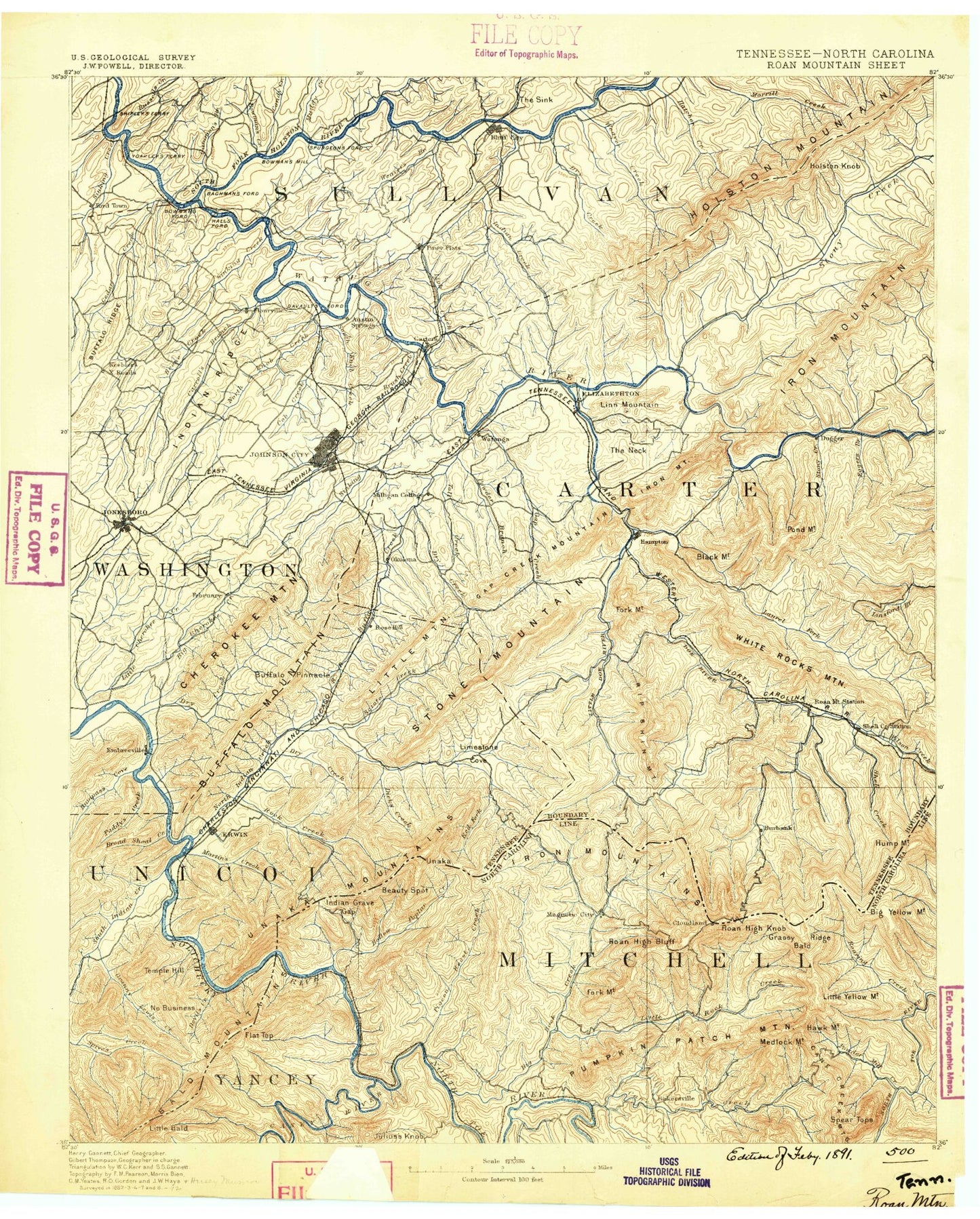
Historical USGS topographic map of Roan Mountain in the state of Tennessee. Scale: 1:125000. Print size: 17" x 24"
This map was published in 1891 and is in the following counties: Avery, Carter, Johnson, Mitchell, Sullivan, Unicoi, Washington, Yancey.
The map contains contour lines, roads, rivers, towns, streams, and lakes. Printed on high-quality waterproof paper with UV fade-resistant inks.
Contains the following named places: Cherry Gap, Low Gap, Yellow Mountain Gap, Big Ball, Ash Gap, Barnett Branch, Bear Branch, Bearwallow Creek, Beauty Spot, Beauty Spot Gap, Big Ridge, Buck Creek, Buckeye Gap, Carvers Gap, Devils Creek, Devils Creek Gap, Engine Gap, Flattop Mountain Branch, Hollow Poplar Creek, Hughes Gap, Indian Grave Gap, Iron Mountain Gap, Little Bald, Little Spivey Creek, Low Gap, Pigeonroost Creek, Roan Mountain, Toll House Gap, Roan High Knob Pinic Area, Beartown Mountain, Ephraim Place, Jane Bald, Little Bald Knob, Little Hump Mountain, Little Rock Knob, Piney Ball, Roan High Knob, Round Bald, Yellow Mountain, Piney Bald, Buffalo Mountain, Campbell Pen Branch, Dunlap Hollow, Five Poplar Branch, Granny Hollow, Laurel Fork Wildlife Management Area, Middle Branch, Shell Creek, Shoemaker Branch, Siam Valley, Sink Branch, Sinking Creek, Smith Hollow, Smith Shoals Subdivision, Smitty Branch, South Pierce Branch, Spivey Falls, Sportsman Dock, Sprolls Hollow, Spurgeon, Spurgeon Knob, Stamping Ground Ridge, Straight Creek, Sugar Hollow, Sugar Hollow, Sugar Hollow Creek, Sulphur Springs Branch, Sulphur Springs Gap, Sycamore Hollow, Tank Hollow, Temple Hill, Temple Hill Gap, Temple Ridge, Tigue Branch, Tillison Branch, Timbered Ridge, Tittle Cove, Toms Branch, Tri-City Dock, Tumbling Creek, Turkey Trail Branch, Unaka Springs, Upper Shell Creek, Valley Forge, Vance Gap, Vanderpool Ridge, Vest Knob, Wagner Bend, Wagner Branch, Wagners Island, Ward Branch, Washington County Fairgrounds, Watauga Lake, Watauga Point Recreational Area, Watts Branch, Weaver Branch, Webb Hollow, White Branch, White Hollow, White Rocks Mountain, Whiteoak Ridge, Wilder Mine Hollow, Woods Branch, Austin Springs, Ayers Ridge, Baker Bluff, Bear Branch, Bear Ridge, Bear Trail Ridge, Bearwallow Branch, Bearwallow Hollow, Bee Cliff, Big Bear Cove Ridge, Big Branch, Big Branch, Big Branch, Big Cove, Big Laurel Branch, Big Nance Ridge, Big Ridge, Big Spring, Bishop Hollow, Black Mountain, Black Mountain Branch, Blevins Hollow, Blue Spring, Bluegrass Hollow, Booher Creek, Booher Knobs, Boone, Boones Creek Dock, Bowers Branch, Bowling Branch, Braemar, Bremer Hollow, Brittle Ridge, Brumit Island, Brummett Hollow, Brushy Ridge Gap, Bryant Ridge, Burbank, Buzzard Cliff, Camp Ten Branch, Campbell Pen Knob, Can Lot, Candy Creek, Candy Creek Dock, Cardens Bluff, Carriger Spring Branch, Cedar Branch, Cedar Gap, Cedar Hill, Centenary Ridge, Chambers Hollow, Cherry Flats Ridge, Chestnut Knob, Clear Fork, Cliff Ridge, Cobb Creek, Coltens Cliff, Cook Branch, Cook Hollow, Cook Ridge, Coon Den Branch, Coon Den Falls, Cordwood Branch, Cove Branch, Cove Creek, Cove Ridge, Cove Ridge Dock, Cox Hollow, Cress Branch, Cripple Creek, Curley Maple Gap, Dale Neely Branch, Dark Hollow, Dave Miller Hollow, Dearden Fill Hollow, Deerlick Bend, Dennis Cove, Depot Hollow, Devault Bend, Dick Creek, Dick Creek Gap, Dogtown, Doll Branch, Doll Flats, Dorn Bluff, Dry Branch, Dry Creek Camp Ground, Duck Branch, East Side, Ellis Hollow, Face Camp Branch, Fall Branch, Fall Creek, Feathers Hollow, Figgins Branch, Firescald Branch, Firescald Knob, First Prong, Fish Springs Dock, Flagpole Point, Flat Ridge, Flint Mill Trail, Fork Ridge, Fourville, Free Hill, Free Hill Tunnel, Frog Level, Gammon Creek, Gap Run, George Creek, Goodwin Field Branch, Goodwin Field Gap, Goosenest Hollow, Granny Lewis Creek, Gray, Greene Hill, Griffith Branch, Hall Ridge Dock, Halls Mill Pond, Ham Smith Branch, Hamby Branch, Hamilton Hill, Hampton, Hampton Creek, Hampton Creek Ridge, Hanks Boat Dock, Hardin Branch, Harris Hollow, Hatley Hollow, Hays Branch, Hazelwood Hollow, Heaton Creek, Heaton Creek Ridge