MyTopo
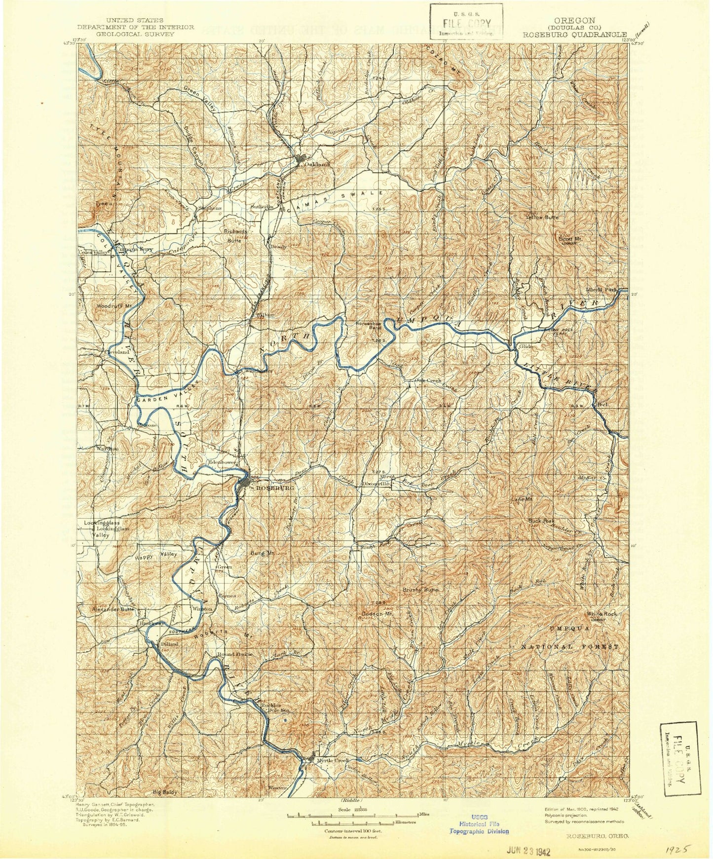
Historic 1900 Roseburg Oregon 30'x30' Topo Map
Couldn't load pickup availability
Historical USGS topographic map of Roseburg in the state of Oregon. Scale: 1:125000. Print size: 17" x 24"
This map was published in 1900 and is in the following counties: Douglas.
The map contains contour lines, roads, rivers, towns, streams, and lakes. Printed on high-quality waterproof paper with UV fade-resistant inks.
Contains the following named places: Norton Creek, Adams Creek, Bachelor Creek, Bald Mountain, Banks Creek, Barrett Creek, Beaty Creek, Ben Branch, Big Baldy, Big Lick, Bilger Creek, Bonanza Mine, Boomer Hill School, Boyd Creek, Bradley Creek, Britt Creek, Brockway Creek, Brome Creek, Brushy Butte, Buck Rock, Burg Mountain, Buzzard Roost Creek, Cabin Creek, Calapooya Creek, Callahan Creek, Camas Swale, Camp Tyee, Cantell Creek, Cedar Hollow, Champagne Creek, Clark Branch, Cleveland, Clover Creek, Coon Creek, Coon Creek, Cooper Creek, Cooper Creek, Cooper Creek, Copeland Butte, Deer Creek, Dixon Creek, Dixonville, Dodge Canyon, Dodson Butte, Doerner Creek, Driver Valley, Eagle Point, East Willis Creek, Engels Creek, Evans Butte, Field Creek, Filler Creek, Fordice Creek, Foster Creek, Fraser Canyon, French Creek, Frozen Creek, Galagher Canyon, Galagher Ridge, Garden Valley, Gassy Creek, Gilbreath Creek, Glide, Gobblers Knob, Gossett Creek, Green Valley, Gross Mountain, Haney Creek, Haney Ridge, Happy Valley, High Point, Hinkle Creek, Hog Creek, Hog Mountain, Whistlers Bend, Hughes Canyon, Huntley Creek, Idleyld Park, Jack Mountain, Jeffers Creek, Kent Creek, Lee Creek, Little Lick, Little Valley, Long Valley Creek, Lookingglass Creek, Lookingglass Valley, Markham Creek, Marsters Creek, Melrose, Mill Creek, Myrtle Creek, Mount Nebo, Newton Creek, Norris Creek, North Fork Calapooya Creek, North Fork Deer Creek, North Fork Hinkle Creek, North Myrtle Park, Oak Creek, Oak Creek Valley, Oakland, Oldham Creek, Parrott Creek, Pelland Creek, Pike Creek, Pine Tree Creek, Pollock Creek, Porter Creek, Rainbow Hollow, Rattlesnake Creek, Rice Creek, Rice Valley, Richards Butte, Richardson Creek, Roberts Creek, Roberts Mountain, Robinson Ridge, Rock Creek Fish Hatchery, Roseburg, Round Prairie, Round Top, School Hollow, Scott Mountain, Shick Creek, Singleton Park, Singleton Valley, Slide Creek, South Fork Calapooya Creek, South Fork Hinkle Creek, Spooner Ridge, Stephens, Stockel Creek, Sutherlin, Sutherlin Creek, Sweetbriar Creek, Taylor Ridge, The Buttes, Timothy Creek, Timothy Ridge, Tyee Mountain, Umpqua, Union Gap, Van Dine Creek, West Willis Creek, Wheeler Canyon, White Creek, Wild Horse, Williams Creek, Willis Creek, Winchester, Winchester Baldy, Winston, Winston Dillard County Park, Woodruff Mountain, Yellow Butte, Yellow Creek, Youngs Bay Lumber Company Dam, Youngs Bay Lumber Company Pond, Salt Lick Creek, Johnston Log Pond, Coles Valley Creek, West Fork High Prairie Creek, East Fork High Prairie Creek, Roseburg Creek, Stewart Gulch, Hamline Creek, Weaver Creek, Cox Gulch, Left Fork Frozen Creek, Eleanor Reservoir, Hughes Creek, Stone Creek, Carson Creek, Sanderson Gulch, Rose Creek, Little River Log Pond, Lone Rock Wayside County Park, Lone Rock Camp, West Fork Britt Creek, Old Hatchery Creek, King Creek, Fair Oaks County Park, Smith Canyon, Whistler Bend County Park, Bull Creek, Black Mud Summit, Livingston Creek, O C Brown County Park, Middle Fork of South Fork Deer Creek, Champagne Creek Valley, Wardton, Harrison Young Brook, Rock Creek, Gobblers Knob, Green Oaks County Park, Umpqua Log Pond, Shady Point Creek, Iverson Log Ponds, Alberson Creek, Alsea Log Pond, Dillard Log Pond, Civil Bend, Lookingglass Hill, Sylman Valley, Sleepy Hollow Creek, Barager Creek, Hestness Park, River Forks County Park, Hidden Valley Creek, Cleveland Rapids, Burke Creek, Dodge Canyon Creek, Cabin Creek Safety Rest Area, Stearns City Park, Martin Mill Pond, Dimmick Creek, Fords Pond, Short Creek, Mar-Linn Log Pond, Amacher County Park, Echo Butte, Davis Creek, Platt 1 Reservoir, Cook Creek, Cooper Creek Dam, Denley Brothers Dam, Dixonville Log Pond Dam, Little River Log Dam, Mar-Linn Timber Corporation Log Pond Dike, Pacific Plywood Corporation Log Pond, Pacific Plywood Dam, Perkins Log Pond, Perkins Log Pond Dam, Platt 1 Dam, Fords Pond Dam