MyTopo
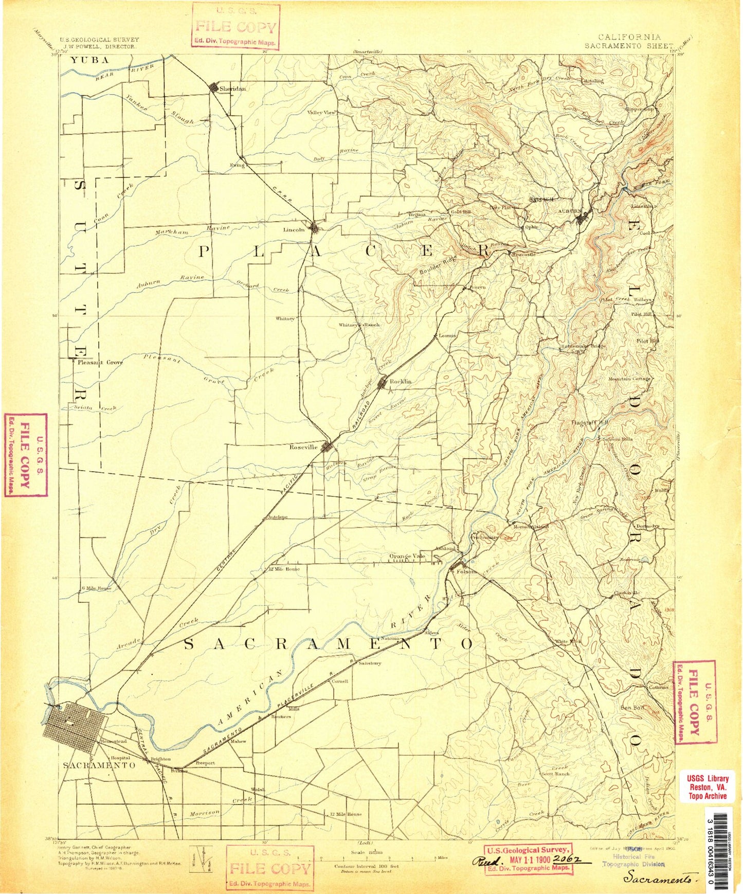
Historic 1893 Sacramento California 30'x30' Topo Map
Couldn't load pickup availability
Historical USGS topographic map of Sacramento in the state of California. Scale: 1:125000. Print size: 17" x 24"
This map was published in 1893 and is in the following counties: Amador, El Dorado, Placer, Sacramento, Sutter, Yuba.
The map contains contour lines, roads, rivers, towns, streams, and lakes. Printed on high-quality waterproof paper with UV fade-resistant inks.
Contains the following named places: Acorn Creek, Alabama Mine, Alder Creek, Alkali Playground, Allegheny Creek, American River Parkway, Ancil Hoffman Park, Anderson Creek, Antelope Canal, Antelope Creek, Arcade Creek, Arden Fair Mall, Lake Arthur, Baer Park, Bald Hill, Baldwin Reservoir, Baltimore Ravine, Barton Canal, Bass Lake, Baughman Canal, Beals Point, Beeks Bight, Bellview Park, Ben Bolt Ridge, Ben Franklin Canal, Big Ravine, Blodgett Reservoir, Blue Ravine, Boulder Mine, Boulder Ridge, Bowman Canal, Bowman Feeder Canal, Brock, Brockway Park, Buffalo Creek, Burgoyne Creek, Camp Pollock, Caperton Canal, Caperton Reservoir, Caps Ravine, Carmichael Park, Carson Creek, Carson Creek School, Chamberlain Ranch, Christian Valley, Chrome Mine, Clark Tunnel, Clarksville, Clover Valley, Clover Valley Creek, Clover Valley Reservoir, Colonial Playground, Cool, Cooper Canyon, Country Club Centre, Country Club Plaza, Coyote Creek, Crabtree Park, Crevis Creek, Cripple Creek, Crocker Creek, Crosby Mine, Curtis Park, Deadman Canyon, Deep Ravine, Del Paso, Del Paso Park, Diamond K Ranch, Discovery Park, Dotons Point, Doty Flat, Doty Ravine, Doty Ravine North Canal, Dry Creek, Dudley Canal, Dutch Ravine, Dutch Ravine, East Portal Park, Ewing, Flagstaff Hill, Folsom Dam, Folsom Lake, Folsom Lake State Recreation Area, Fremont Park, Gasoline Alley, Georges Ravine, Gibson Ranch County Park, Goethe Park, Gold Blossom Canal, Goose Flat, Granite Bay, Granite Ravine, Grant Playground, Green Spring Creek, Hagginwood Park, Hall Park, Halsey Forebay, Hancock Creek, Henschel Park, Highway Forty Mine, Honor Camp Number Seven, Hotaling, Howe Community Park, Hughes Stadium, Humbug Creek, Hunkle Reservoir, Indian Creek, Indian Springs Creek, Ingram Slough, Iron Mountain, Johnston Park, Kaseberg Creek, Kelly Ravine, Knickerbocker Canyon, Lake Natoma Trail, Latrobe Creek, Lawrence Playground, Lime Rock, Lincoln Canal, Lincoln Rodeo Grounds, Little Deer Creek, Louisiana Bar, Madera Park, Magpie Creek, Mangan Park, Marshall Park, Martel Creek, Mary Len Mine, Mather Lake, McClatchy Park, McKinley Park, Mills, Miners Ravine, Mississippi Bar, Mooney Ridge, Morgan Canal, Mormon Hill, Mormon Island Dam, Mormon Ravine, Mount Vernon Grange, Muir Playground, Murderers Bar, Murderers Gulch, Natomas Ditch, Negro Bar, New York Bar, New York Creek, Newcastle Canal, Nimbus Dam, North Fork Dam, North Fork Ditch, North Ravine, Oak Park, Ophir Canal, Orchard Creek, Orr Creek, Orr Creek Dam, Peacock Ravine, Penryn, Penryn Canal, Perry Canal, Pilot Creek, Pilot Hill, Pilot Hill, Pioneer Park, Pleasant Grove, Pointed Rocks, R F Fiddyment Ranch, Red Ravine Canal, Redwood Park, Richardson Village Park, Riego, Rock Creek, Rock Creek Dam, Rock Creek Lake, Roosevelt Park, Rose Spring Ditch, Roseville Reservoir, Rusch Park, Russell Hollow, Sailor Bar, Sailors Ravine, Salt Creek, San Juan Park, Santa Anita Park, Screech Owl Creek, Secret Ravine, Sheridan, Shirland Canal, Shirttail Peak, Sicily Mine, Sim Park, Skunk Canyon, Slate Creek, Chicken Ranch Slough, Fiddler Green Canal, Lower Fiddler Green Canal, New Helvetia, Pioneer Express Trail, Plunkett Creek, Rebel Hill Ditch, Rio De Los Americanos, San Juan, South Branch Pleasant Grove Creek, South Canal, South Canal, South Sutter Ditch, Spring Valley Ranch, Stanford Playground, Strap Miner Creek, Strap Ravine, Strizek Park, Strong Ranch Slough, Sugar Pine Mountain, Sugarloaf Canal, Sunnybrook Farm, Sutter Slough, Sutter's Fort State Historic Park, Sweetwater Creek, Tahoe Park, Tamaroo Bar, Lake Theodore, Turner Canal, Upper Bowman Canal, Valley View Canal, Valley View Reservoir, W F Fiddyment Ranch, Warner Ravine, Westwood Park, Whisky Diggins Canal, Whisky Hill, Whisky Run, Wildcat Canyon, William Land Park, Willow Creek, Willow Hill Reservoir