MyTopo
Historic 1901 Saint Xavier Montana 30'x30' Topo Map
Couldn't load pickup availability
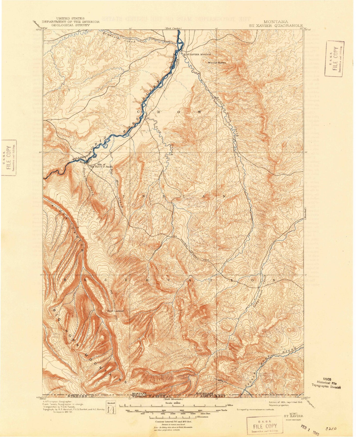
Historical USGS topographic map of Saint Xavierin the states of Montana, Wyoming. Scale: 1:125000. Print size: 17" x 24"
This map was published in 1901 and is in the following counties: Big Horn, Sheridan.
The map contains contour lines, roads, rivers, towns, streams, and lakes. Printed on high-quality waterproof paper with UV fade-resistant inks.
Contains the following named places: West Soap Creek, Absaloka Youth Camp, Ash Coulee, Aspen Grove Cabin, Barber Ranch, Bear Hole, Beauvais Creek, Beaver Creek, Big Bull Elk Ridge, Big Cottonwood Creek, Big Horn Canal, Black Cabin, Black Canyon Basin, Black Canyon Creek, Black Gulch, Black Gulch Ditch, Black Gulch Point, Box Canyon, Brock Coulee, Buck Creek, Buck Ridge, Buffalo Horn Ridge, Camp Four, Christmas Tree Coulee, Cooper Basin, Cooper Basin Coulee, Cooper Ridge, Cottonwood Coulee, Coyote Creek, Deer Creek, Del Howe Coulee, Dick Creek, Dry Fork Coulee, Dry Soap Creek, Eagle Point, East Dipping Vat Coulee, Edge Creek, Eskimo Creek, Eychaner Coulee, Goose Coulee, Graham Ditch, Grapevine Creek, Halfway Canyon, Hay Coulee, Horse Ridge Canyon, Hunter Cabin, Jess Coulee, Jimmy Creek, Johnny Creek, Krone Ditch, Lime Kiln Creek, Limestone Canyon, Little Cottonwood Creek, Little Land, Lodge Grass Canyon, Lodge Grass Feeder Canal, Lodge Grass Storage Reservoir, Long Ridge, Lotties Draw, Mission Buttes, Mission Coulee, Mott Creek, Muddy Creek, North Fork Lodge Grass Canyon, North Fork Rotten Grass Canyon, Ox Yoke Coulee, Packs the Hat Creek, Percheron Creek, Peyote Point, Point Lookout, Powerhouse Yellowtail Dam, Powers Upper Ditch, Rattlesnake Butte, Red Canyon Creek, Robert Miller Ditch, Rocky Ridge, Rotten Grass Canyon, Rotten Grass Creek, Saint Xavier, Saint Xavier Coulee, Salt Ridge, Saw Log Canyon, Shick Ranch, Scott Coulee, Shoulder Blade Camp, Siemion Ranch, Soap Creek, Soap Creek Canyon, Soap Creek Ditch, Soap Creek Oilfield, Soldier Trail, South Fork Hay Coulee, South Fork West Soap Creek, Sport Creek, Spring Creek, Spring Creek, Twin Peaks, Stevie Creek, Telephone Ridge, Tepee Pole Ridge, The Beaver Slide, The Buffalo Pasture, The Mesa, The Rocky Bottom, Three Springs Trail, War Man Creek, War Man Mountain, West Dipping Vat Coulee, Willcutt Ranch, William Miller Ditch, Willow Creek, Willow Creek Dam, Windy Point Lookout, Wolf Ranch, Yellowtail Dam, Bighorn Canyon, Mountain Pocket Creek, Fort Smith, Crow Number 67 Dam, Yellowtail Afterbay Dam, Yellowtail Afterbay Reservoir, Erb Number 1 Dam, Crow Number 47 Dam, Crow Number 46 Dam, Crow Number 53 Dam, Fort Smith Sewage Disposal Ponds Dam, Crow Reservation, Halfway Canyon, Horse Ridge Canyon, West Fork Little Bighorn River, Lotties Draw, Red Gulch, Cottonwood Camp, Afterbay Campground, Big Horn Mountains, Bighorn Fishing Access Site, Crow Reservation Division, Black Gulch, Buck Creek, Dry Fork Coulee, Edge Creek, Eskimo Creek, Halfway Canyon, Horse Ridge Canyon, Lodge Grass Canyon, Lotties Draw, Red Canyon Creek, Bighorn Canyon, Halfway Canyon, Horse Ridge Canyon, West Fork Little Bighorn River, Lotties Draw, Red Gulch