MyTopo
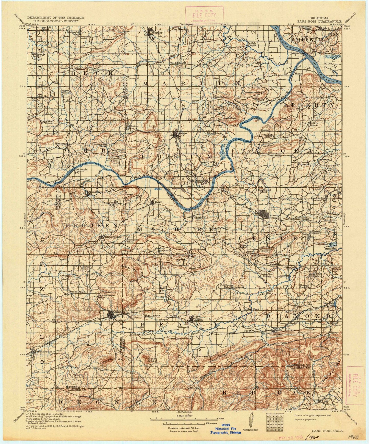
Historic 1911 San Bois Oklahoma 30'x30' Topo Map
Couldn't load pickup availability
Historical USGS topographic map of San Boisin the states of Oklahoma, Arkansas, Texas, New Mexico, Colorado. Scale: 1:125000. Print size: 17" x 24"
This map was published in 1911 and is in the following counties: Haskell, Latimer, McIntosh, Muskogee, Pittsburg, Sequoyah.
The map contains contour lines, roads, rivers, towns, streams, and lakes. Printed on high-quality waterproof paper with UV fade-resistant inks.
Contains the following named places: Andrew Creek, Askew Hollow, Barker Mountain, Bear Creek, Bear Creek, Bear Gulch, Beaver Creek, Beaver Mountain, Bee Bluff, Belle Starr Creek, Bird Hollow, Black Gum Flats, Black Haw Mountain, Blu Mountain, Blue Mountain, Briartown, Briartown Creek, Brier Creek, Brooken Creek, Brooken Mountain, Buzzard Hollow, Camp Creek, Cedar Creek, Cedarburg Creek, Chickasaw Creek, Choctaw Mine, Club Lake, Coblentz Lake, Dirty Creek, Dry Creek Hollow, Duchess Creek, Dunigan Mountain, Eaton Creek, Elm Creek, Emachaya Creek, Enterprise, Eufaula Dam, Featherston Creek, Fenton Lake, Fish Creek, Gap Prairie, Grassy Lake Hollow, Gritts Hill, Harris Mountain, Haytubbi Creek, Heifer Creek, Hensley Mountain, Hi Early Mountain, Hickory Ridge, Hisaw Bottom, Holt Mountain, Hornback Creek, House Creek, Hoyt, Huckleberry Hollow, Hulsey Mountain, Illinois River, Iron Post Mountain, Jackson Creek, John Wells Park, Kings Creek, Kinta, Kinta Lake, Lake John Wells, Lancaster Hollow, Lequire, Little Beaver Creek, Little Knob, Little Round Mountain, Little Yancy Mountain, Lona Valley, Lone Star Steel Lake, Long Mountain, McClure Creek, Mill Creek, Morgan Mountain, Mountain Fork, Mud Creek, Mule Creek, Mount Nebo, Negro Creek, Panther Hollow, Panther Mountain, Piney Creek, Porum, Porum Gap, Possum Hollow Creek, Pruit Valley, Quinton, Quinton City Lake, Rabbit Hill, Red Bluff, Right Prong Mountain Fork, Robbers Cave State Park, Rough Canyon, Round Mountain, Round Mountain, Russellville Branch, Ryan Peak, Sally Jones Lake, Sandy Ridge, Sans Bois Mountains, Shady Grove Creek, Shoe Mountain, Shropshire Valley, Smokestack Hollow, Snake Creek, South Fork Dirty Creek, Standing Rock Mountain, Stanifird Mountain, Starvilla Creek, Stigler, Stigler Lake, Sulfur Creek, Taloka Creek, Tater Hill, Taylor Bluff, Texanna Branch, Texanna Mountain, Tucker Knob, Turkey Creek, Turkey Flat, Turkey Knob, Twentynine Hollow, Upper Sandtown Bottom, Upson Siding, Vaughn Hollow, Warner, Warner Lake, White Rocks, Whitefield, Winters Hollow, Sequoyah National Wildlife Refuge, Featherston, Garland, Highway 9 Landing, Hughart, Lafayette, Lewisville, Lodi, Russellville, Shady Grove, Texanna, Haskell County, Canadian River, Sans Bois, Youth Camp Number 2, Fenton Lake Dam, Oknoname 361001 Dam, Oknoname 361001 Reservoir, Lake John Wells Dam, Oknoname 131007 Dam, Kinta Lake Dam, Quinton Lake Dam, Quinton Lake, Coblentz Lake Dam, Oknoname 111032 Dam, Oknoname 111032 Reservoir, Cowden Laterals Site 12 Dam, Cowden Laterals Site 12 Reservoir, Porum Lake Dam, Porum Lake, Oknoname 101010 Dam, Oknoname 101010 Reservoir, Oknoname 101011 Dam, Oknoname 101011 Reservoir, Oknoname 101012 Dam, Oknoname 101012 Reservoir, Oknoname 101013 Dam, Oknoname 101013 Reservoir, Oknoname 101014 Dam, Oknoname 101014 Reservoir, Oknoname 101015 Dam, Oknoname 101015 Reservoir, Oknoname 101017 Dam, Oknoname 101017 Reservoir, Oknoname 121003 Dam, Oknoname 121003 Reservoir, Oknoname 121015 Dam, Oknoname 121015 Reservoir, Robert Mitchell Lake Dam, Robert Mitchell Lake, Stigler Dam, Duchess Creek Wildlife Management Area, Township of Vann, Township of Martin, Township of Porum, Township of Cobb, Township of Quinton, Township of Liberty, Township of Taloka, Township of Brooken, Township of Machire, Township of Center, Township of Beaver, Township of Diamond, Duchess Landing, Checotah Division, McCurtain Division, Porum Division, Stigler Division, Warner Division, West Haskell Division, City of Stigler, Town of Porum, Town of Quinton, Town of Kinta, Town of Tamaha, Town of Warner, Town of Webbers Falls, Town of Whitefield, Simms, County District 5, Duchess Landing, McIntosh Non-Community, Shady Grove Community, Simms, Texanna, Illinois River, Canadian River, Canadian River, Canadian River