MyTopo
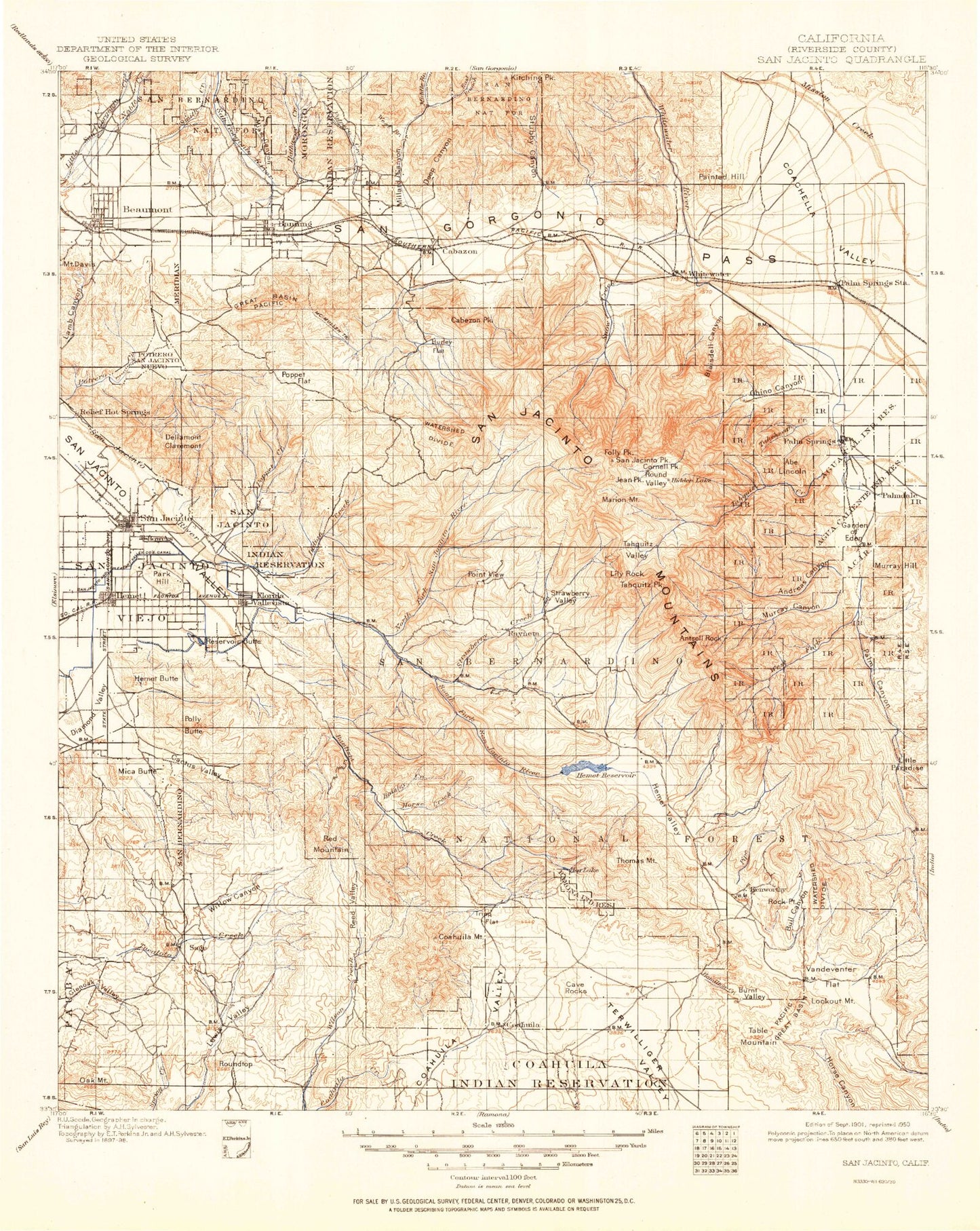
Historic 1901 San Jacinio California 30'x30' Topo Map
Couldn't load pickup availability
Historical USGS topographic map of San Jacinio in the state of California. Scale: 1:125000. Print size: 17" x 24"
This map was published in 1901 and is in the following counties: Riverside.
The map contains contour lines, roads, rivers, towns, streams, and lakes. Printed on high-quality waterproof paper with UV fade-resistant inks.
Contains the following named places: Bald Mountain, Bautista Creek, Bautista Wash, Big Morongo Wash, Black Hills, Black Mountain Camp, Black Mountain Truck Trail, Blind Canyon, Bulls Eye Rock, Castile Canyon, Cornell Peak, Cottonwood Canyon, Cox Ranch, Dark Canyon Camp, Desert Divide Trail, Devers Hill, Devils Garden, Dry Morongo Wash, Duchess Canyon, East Branch Snow Creek, East Fork Palm Canyon, East Fork Snow Creek, Falls Creek, Fern Basin Campground, Fobes Ranch, Foster Lake, Fuller Mill Creek, Fuller Mill Creek Camp, Fuller Ridge, Garnet Hill, Garnet Ridge, Garnet Wash, Glenoak Valley, Goff Flat, Hamilton Creek, Hells Kitchen, Hermits Bench, Hidden Falls, Hidden Lake, Hidden Lake Divide, Humber Park, Indian Creek, Indian Potrero, Jenson Creek, Juaro Canyon, Kitching Peak, Laws Camp, Lazy C Ranch, Lewis Valley, Lion Peak, Little Desert, Little Morongo Wash, Little Round Valley, Little Tahquitz Valley, Long Valley, Lost Heads Ranch, Marion Creek, Marion Mountain Campground, Marion Ridge, Massacre Canyon, McGregor Flat, Mesquite Flat, Midway Canyon, Morris Ranch, Mount San Jacinto State Park, Needles Eye, Oak Canyon, Oak Mountain, One Horse Creek, Painted Hill Quarry, Painted Hill Trail, Palm Springs Station, Park Hill, Pine Cove, Pine Flat Camp, Pine Mountain, Poppet Creek, Pyramid Peak, Camp Azalea Trails, Camp Lackey, Rocky Ridge, Round Valley, Roundtop, Sacaton Flat, Saint Johns Grade, San Gorgonio River, San Jacinto Peak, San Jacinto Reservoir, San Jacinto Viejo, Skunk Cabbage Meadow, Snow Canyon, Snow Creek, Snow Creek, Soboba Reservation, Stubbe Canyon, Suicide Rock, Super Creek Mine, Tahquitz Meadow, Tamarack Valley, Tripp Meadow, Tucalota Valley, Weber Valley, Wellman Divide, Wellmans Cienaga, West Fork Palm Canyon, West Fork Snow Creek, White House Canyon, Whitewater Hill, Whitewater Trout Farm, Willow Canyon, Willow Creek, Windy Point, Newton Drury Peak, Dark Canyon, One Horse Ridge, The Matterdome, Garnet, Ditch Creek, Cahuilla Valley, Morongo Reservation, Alessandro Trail, Alvin Meadows, Andreas Canyon, Andreas Falls, Angelus Hill, Antsell Rock, Anza, Apache Peak, Apple Canyon, Avery Canyon, Azalea Creek, Baisley Creek, Banning Bench, Banning Canyon, Banning Ranger Station, Barker Peak, Bautista Guard Station, Bear Trap Canyon, Bee Canyon, Bee Canyon Truck Trail, Black Mountain, Black Mountain Creek, Black Mountain Trail, Blackburn Canyon, Blaisdell Canyon, Blodgett Flat, Bogart County Park, Bonita Vista Ranch, Brown Canyon, Brown Creek, Bull Canyon, Burnt Valley, Burro Flats, Butterfly Peak, Cabazon Shaft, Cactus Valley, Cahuilla Reservation, Cahuilla Mountain, Camp Emerson, Camp Roosevelt, Camp Maranatha, Caramba Camp, Pine Springs Ranch, Chalk Hill, Cherry Canyon, Chimney Flats, Chino Canyon, Cholla Canyon, Cinco Poses Trail, Cahuilla, Coldwater Creek, Corral Canyon, Cottonwood Canyon, Cottonwood Fire Break, Coyote Creek, Mount Davis, Deep Canyon, Desert Angel, Dry Creek, Durasno Valley, Dutch Charlie Canyon, East Branch Millard Canyon, East Portal Adit, Mount Edna, Elder Creek, Fleming Ranch, Lake Fulmor, Garnet Queen Creek, Gibbe Flat, Goodhart Canyon, Goodhart Ranch, Green Canyon, Hall Canyon, Hathaway Creek, Hemet Butte, Garner Valley, Lake Hemet, Herkey Creek, Hurkey Creek Campground, Hidden Fork, Hixon Flat, Hog Lake, Horse Creek, Rouse Ridge, Potrero Canyon, Hungry Hollow, Hurley Flat, Indian Creek Truck Trail, Indian Mountain, Johnston Meadow, Juan Diego Flat, K Flat, Keen Camp, Keen Camp Summit, Keen Ridge, Keenwild Station, Ken Wortity Station, Kimmel Canyon, Lake Hemet Main Canal, Lilly Creek, Lion Canyon, Little Cahuilla Mountain, Little Lake, Little Morongo Canyon, Little Morongo Creek, Little Thomas Mountain, Live Oak Canyon, Logan Creek, Long Valley Creek, Lookout Mountain, Lorenz Canyon, Lucky Deer Mine, McMullen Flat, Mellor Creek, Metate Flat, Mica Butte