
MyTopo
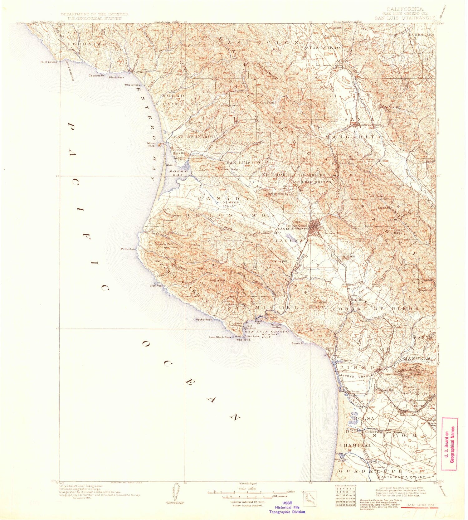
Historic 1900 San Luis California 30'x30' Topo Map
Couldn't load pickup availability
Historical USGS topographic map of San Luis in the state of California. Scale: 1:125000. Print size: 18" x 24"
This map was published in 1900 and is in the following counties: San Luis Obispo.
The map contains contour lines, roads, rivers, towns, streams, and lakes. Printed on high-quality waterproof paper with UV fade-resistant inks.
Contains the following named places: Estero De Limantour, Adobe Canyon, Adobe Canyon, Asistencia de Santa Margarita, Avila Rock, Avila State Beach, Bald Knob, Baywood Park, Beck Lake, Big Pocket Lake, Big Twin Lake, Bird Rock, Bishop Peak, Black Hill, Black Lake, Black Lake Canyon, Black Rock, Bolsa Chica Lake, Brizzolara Creek, Calf Canyon, Camp San Luis Obispo, Castro Canyon, Castro Mine, Cayucos Point, Cayucos State Beach, Celery Lake, China Harbor, Chorro Reservoir, Cienega Valley, Clark Valley, Clear Lake, Constantine Rock, Crowbar Canyon, Cuesta, Cuesta Canyon County Park, Cuesta Pass, Dairy Creek, Dark Range Peak, Davis Canyon, Little Irish Canyon, Diablo Canyon, Double Rock, El Chorro, Ellysly Creek, Eto Lake, Fairbank Point, Fern Canyon, Fossil Point, Froom Creek, Garden Farms, Granite Ridge, Green Peak, Happy Valley Ranch, Harford Canyon, Hazard Canyon, Hospital Lake, Howell Rock, Indian Knob, Islay Creek, Jack Lake, La Trinidad Mine, Laguna, Laguna Lake, Lansing Rock, Lettuce Lake, Lion Rock, Little Cayucos Creek, Little Oso Flaco Lake, Lone Black Rock, Lone Rock, Los Berros Canyon, Los Berros Creek, Los Osos, Los Osos Creek, Meadow Creek, Mehlschau Creek, Mine Canyon, Mine Hill, Mission Lands, Montana de Oro State Park, Morro Bay State Park, Morro Strand State Beach, Mouse Rock, Mud Lake, Nipomo Hill, North Beach Campground, Oso Flaco Creek, Oso Flaco Lake, Park Ridge, Pecho Creek, Pecho Rock, Picacho, Pick and Shovel Mine, Pipeline Lake, Pismo Bench, Pismo Lake, Pismo State Beach, Point Buchon, Point San Luis, Primera Mine, Ranchita De Santa Fe, Reservoir Canyon, Rocky Canyon, Ruda Canyon, Saddle Peak, San Geronimo, San Luis Obispo Bay, San Miguelito, Santa Margarita, Santa Margarita Creek, Santa Margarita Fire Control Station, Santa Rosa Park, Santa Rosa Reef, See Canyon, Silver Lake, Small Twin Lake, Smith Island, South Point, Squire Canyon, Stenner Creek, Sycamore Canyon, Sycamore Canyon, Terrace Hill, Trout Creek, Valencia Peak, Villa Creek, Vineyard Canyon, Warden Lake, Westdahi Rock, Whale Rock, White Lake, White Point, White Rock, Wild Cherry Canyon, Willow Lake, Yerba Buena Creek, Hollister Peak, Callender, Huerta de Romauldo, Mount Buchon, San Luis Obispo County Wharf, Harford Pier, Potrero de San Luis Obispo, Avila Beach, Cayucos Creek, Cerro Romualdo, Cerro San Luis Obispo, Chumash Peak, Coon Creek, Moreno Creek, Morro Bay, Morro Rock, Gragg Canyon, Arroyo Grande Creek, Arroyo Grande Valley, Asuncion, Atascadero Lake, Atascadero Lake, Atascadero, Atascadero State Beach, Bald Mountain, Bee Canyon, Big Falls Canyon, Black Butte, Bolsa de Chamisal, Burrito Creek, Canada Verde, Canada De Los Osos Y Pecho Y Islay, Canyon de los Alisos, Canyon Number 1, Canyon Number 2, Carpenter Canyon, Cerro Alto, Cerro Alto Campground, Chorro Creek, Corbit Canyon, Corral De Piedra, Corralitos Valley, Cottontail Creek, Coyote Point, Davenport Creek, Deer Canyon, Devils Gap, Eagle Creek, Eagle Peak, Eagle Ranch, East Corral de Piedra Creek, East Fork Morro Creek, Edna, Estero Bay, Frog Pond Mountain, Gay Mountain, Guaya Canyon, Hale Creek, Hampton Canyon, Henry, Irish Hills, Kathleen Valley, Little Morro Creek, Long Valley, Lopez Mountain, Los Osos Valley, Miller Flat, Moro Y Cayucos, Morro Creek, Newsom Canyon, Nipomo, Oil Well Canyon, Old Creek, Orange Flat, Paloma Creek, Paradise Valley, Pennington Creek, Pilitas Creek, Pine Mountain, Piney Ridge, Pismo, Pismo Creek, Poorman Canyon, Potrero Creek, Prefumo Creek, Price Canyon, Quail Flat, Rattlesnake Canyon, Rinconada Creek, Rocky Gorge, Round Top, Rusty Peak, San Bernardo, San Bernardo Creek, San Luis Hill, San Luis Obispo Creek, San Luisito, San Luisito Creek, Santa Margarita, Slide Hill


