MyTopo
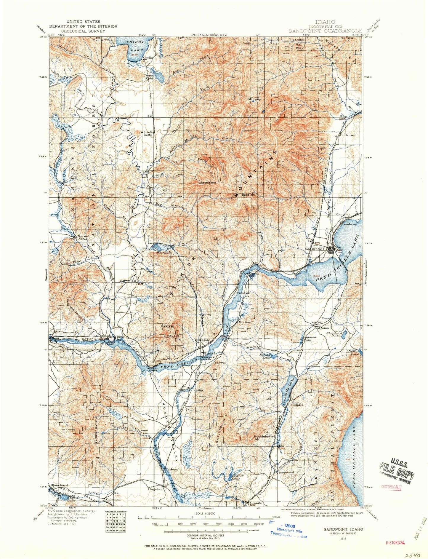
Historic 1911 Sand Point Idaho 30'x30' Topo Map
Couldn't load pickup availability
Historical USGS topographic map of Sand Point in the state of Idaho. Scale: 1:125000. Print size: 16" x 24"
This map was published in 1911 and is in the following counties: Bonner.
The map contains contour lines, roads, rivers, towns, streams, and lakes. Printed on high-quality waterproof paper with UV fade-resistant inks.
Contains the following named places: Chicopee Creek, Alder Creek, Algoma, Beaver Creek, Beaver Lake, Beaver Lake Ranch, Benton Creek, Berry Creek, Big Creek, Bimetallic Ridge, Binarch Creek, Blanchard Creek, Blanchard Lake, Blonc Creek, Blue Creek, Blue Mountain, Bridgeview Creek, Canoe Camp, Canyon Creek, Canyon Gap, Cape Horn Creek, Careywood Creek, Caribou Creek, Caribou Lake, Caribou Lookout, Mount Casey, Chase Creek, Chase Lake, Chipmunk Rapids, Chuck Slough, Cocolalla Creek, Cocolalla Lake, Colburn Creek, Colburn Lake, Contest Point, Coolin Mountain, Cottonwood Creek, Cottonwood Point, Crazy Creek, Curtis Creek, Devils Creek, Dickensheet Campground, Dubius Creek, Dufort, East Fork Moores Creek, East River, Fish Creek, Fish Creek, Fox Creek, French Creek, Fry Creek, Gleason Meadow, Goose Creek, Granite Lake, Gravel Pit, Guinn Creek, Happy Fork, Happy Fork Gap, Hathaway Creek, Hays Gulch, Heath Lake, Hellroaring Creek, Hellroaring Ridge, Hickman Creek, Hoodoo Creek, Hoodoo Lake, Hope and Faith Shaft, Hornby Creek, Jack Creek, Jack Pine Flats, Jewel Lake, Johnson Creek, Jungle Creek, Junta Creek, Kavanaugh Creek, Kelso Lake, Keokee Creek, Keokee Lake, Keokee Mountain, Koch Creek, Kootenai Bay, Kreiger Creek, Lamb Creek, Lambertson Lake, Lee Creek, Lee Lake, Lindsey Creek, Little Lake, Little Muskrat Lake, Little Pine Creek, Little Sand Creek, Lost Creek, Maiden Creek, Maiden Rock, Manley Creek, McAbee Falls, Melder Draw, Micro Creek, Middle Fork East River, Mission Falls, Moore Creek, Moores Creek, Morton Slough, Mountain Meadow, Murphy Bay, Murphy Slough, Murray Creek, Muskrat Lake, North Fork Big Creek, North Fork East River, Otts Basin, Outlet Bay, Outlet Campground, Outlet Dam, Peewee Creek, Pine Creek, Poirier Creek, Ponder Point, Prater Creek, Priest River, Priest River Experimental Forest, Priest River Park, Puzzle Creek, Quartz Creek, Race Creek, Ranger Creek, Riley Creek, Riley Creek Recreation Area, Rocky Point, Round Lake, Round Lake, Round Lake State Park, Sagle, Sagle Slough, Sanborn Creek, Sand Creek, Schweitzer Basin, Schweitzer Creek, Shepherd Lake, Smith Creek, Snow Creek, Snow Valley, Spirit Creek, Steep Creek, Sundance Mountain, Swede Creek, Syringa Creek, Tarlac Creek, Tavern Creek, The Settlement, Three Sisters Creek, Tunnel Creek, Turnipseed Creek, Uleda Creek, Uleda Point, Upper West Branch Priest River, Vay, Waters Creek, West Fork Moores Creek, Westmond Creek, Whitetail Butte, Lower West Branch Priest River, Albeni Cove Campground, Strong Island Picnic Area, Priest River Campground, North Shore Game Management Area, Albeni Falls Dam Picnic Area, Maiden Rock Picnic Area, Evans Landing Picnic Area, Morton Slough Access, Morton Slough Game Management Area, Round Lake Campground, Mallard Bay, Reed Hill, Kelso Lake Access, Granite Lake Access, Springy Point Campground, Osprey Nests Viewpoint, Sagle Community Hall, Mirror Lake Access, Huckleberry Mountain Lookout, Carey Boat Ramp, Carey Pits, Laclede Boat Ramp, Woodside, Pewee Peak, Kaniksu Marsh Research Natural Area, Chipmunk Rapids National Recreation Trail, Triangle Park, Gisbourne Mountain Vista, Colburn Day Lodge, Atlasta Mountain, Bonner County Fairgrounds, Bronx Substation, Sandpoint Mall, Pine Street Park, Canyon Creek Recreational Natural Area, Schweitzer Basin Ski Area, Pine Street Ski Area, Carey Creek Game Management Area, East Kootenai, Priest River Experimental Station, Plumbago Point, Sundance Lookout Station, Bonner Mall, Bonner County, Albeni Falls Campground, Lost Peak, Lake Plaza, Bald Mountain, Black Pine Mountain, Blacktail Mountain, Blanchard, Careywood, Cocolalla, Colburn, Coleman, Coolin, Cuban Hill, Dickensheet Junction, Edgemere, Evans Landing, Gisborne Mountain, Gold Cup Mountain, Grouse Mountain, Harlem, Hoodoo Mountain, Horn Mountain, Johnny Long Mountain, Laclede, Lindsey Mountain, Little Blacktail Mountain, Long Mountain, Morton, Outlet Bay, Outlet Mountain