MyTopo
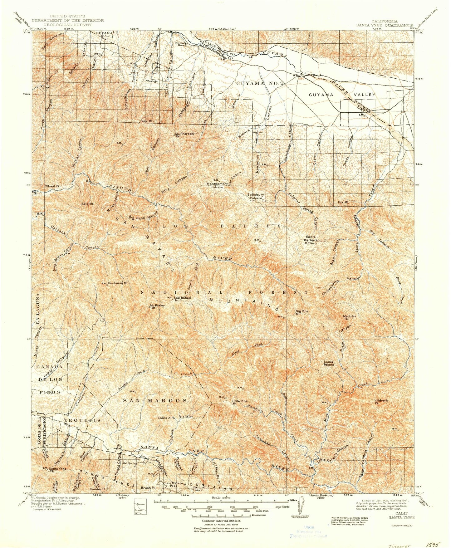
Historic 1905 Santa Ynez California 30'x30' Topo Map
Couldn't load pickup availability
Historical USGS topographic map of Santa Ynez in the state of California. Scale: 1:125000. Print size: 18" x 24"
This map was published in 1905 and is in the following counties: San Luis Obispo, Santa Barbara.
The map contains contour lines, roads, rivers, towns, streams, and lakes. Printed on high-quality waterproof paper with UV fade-resistant inks.
Contains the following named places: Alamar Hill, Alexander Peak, Aliso Canyon, Arroyo Burro, Bear Creek, Big Cone Spruce Camp, Black Canyon, Brush Peak, Bull Ridge, Cachuma Mountain, Cliff Canyon, Coche Creek, Cold Spring Canyon, Cuyama, Doty Cabin, Flores Camp, Four-H Camp, Fremont Campground, Gibraltar Reservoir, Goddard Picnic Ground, Horse Potrero, Hurricane Deck, Jackson Trail, Kelly Creek, La Jolla Basin, Lewis Canyon, Lion Canyon, Logan Potrero, Loma Alta, Los Laureles Canyon, Los Prietos Boys Camp, Los Prietos Campground, Los Prietos Ranger Station, Lower Oso Campground, Manzana Camp, Manzana Narrows Camp, Manzana Trail, Mine Canyon, Mine Canyon, Mission Pine Camp, Nineteen Oaks, Old Man Mountain, Oso Canyon, Paradise Canyon, Paradise County Park, Peachtree Canyon, Pine Corral, Quail Canyon, Quail Spring Reservoir, Rattlesnake Canyon, Rattlesnake Trail, Redrock Canyon, Round Potrero, San Marcos, San Marcos Pass, San Marcos Ranch, San Rafael Mountain, Santa Barbara Potrero, Santa Cruz Guard Station, Santa Cruz Peak, Santa Cruz Trail, Seagull Canyon, Skunk Campground, South Fork Guard Station, South Fork Sisquoc River, Stovall Canyon, Sulphur Spring Canyon, Sweetwater Trail, The Narrows, The Pines Campground, The Wash, Trough Canyon, Upper Horse Canyon, Upper Oso Campground, West Fork Santa Cruz Creek, White Ledge Canyon, Windsor Canyon, Cold Spring, Abel Canyon, Agua Caliente Canyon, Agua Caliente Trail, Alamar Canyon, Alamar Guard Station, Alamar Hill Trail, Alamar Trail, Alamo Canyon, Aliso Campground, Aliso Canyon, Angle Canyon, Arrowhead Island, Bald Mountain, Bald Mountain Canyon, Ballinger Canyon Wash, Bates Canyon, Bates Canyon Campground, Bear Campground, Bee Rock, Bee Rock Canyon, Big Bend Canyon, Big Pine Campground, Big Pine Canyon, Big Spring Canyon, Bill Farris Campground, Bitter Creek, Blue Canyon, Bluff Campground, Boot Canyon, Branch Canyon, Branch Canyon Campground, Branch Canyon Wash, Broadcast Peak, Buckhorn Creek, Buckhorn Trail, Burro Canyon, Cachuma Bay, Cachuma Camp, Lake Cachuma County Park, Cachuma Creek, Bradbury Dam, Cachuma Point, Lake Cachuma Recreation Area, Cachuma Saddle Guard Station, Lake Cachuma, Caliente Ranch, Camp Drake, Camuesa Creek, Camuesa Peak, Castro Canyon, Central Canyon, Chokecherry Canyon, Clark Canyon, Coche Campground, Coldwater Campground, Cole Spring Campground, Condor Point, Cottonwood Campground, Cox Canyon, Cox Flat, Coyote Gulch, Cuyama Ranch, Davy Brown Campground, Davy Brown Creek, Davis Canyon, De la Guerra Camp, DeVaul Canyon, Deadman Canyon, Devils Canyon, Diablo Canyon, Docs Spring Campground, Don Victor Campground, Don Victor Canyon, Don Victor Valley, Dry Canyon, Dutch Oven Campground, East Canyon, East Fork Diablo Canyon, East Fork Fish Creek, East Fork Santa Cruz Creek, East Pinery, Eckart Canyon, Fall Canyon, Figueroa Camp, Figueroa Mountain, Fir Canyon, Fish Creek, Fish Creek Campground, Foot Trail, Foresters Leap Canyon, Fox Mountain, Gato Trail, Gibraltar Dam, Gidney Creek, Gibraltar Mine, Goode Canyon, Grapevine Creek, Grapevine Trail, Happy Hollow Guard Station, Heath Campground, Hells Half Acre, Hidden Potrero, Hildreth Peak, Hilton Canyon, Horse Canyon, Horse Canyon, Horse Canyon, Hot Spring Canyon, Hurricane Deck Trail, Indian Creek, Indian Creek Campground, Jackrabbit Flat, Johnson Canyon, Judell Canyon, Lacosca Creek, Lazaro Canyon, Lion Canyon, Little Caliente Canyon, Little Spring Canyon, Logan Canyon, Loma Pelona, Los Prietos Y Najalayegua, Lower Alamar Campground, Lower Bear Campground, Lower Grapevine Campground, Madulce Guard Station, Madulce Peak, Madulce Trail, Manzana Campground, Manzana Creek, Marre Ranch, McPherson Peak, Messenger Canyon, Middle Canyon, Middle Canyon, Middle Santa Ynez Campground, Miller Canyon, Mission Pine Basin, Mission Pine Trail, Mono Alamar Trail, Mono Campground, Mono Creek, Montgomery Potrero, Moon Canyon, Munch Canyon, Narrows Campground, New River, Newsome Canyon, Nira Campground, North Portal, Oak Canyon, Ogilvy Ranch, Oil Canyon, Olive Canyon, P-Bar Flats, P-Bar Flats Campground, Padrones Canyon, Peacock Mine