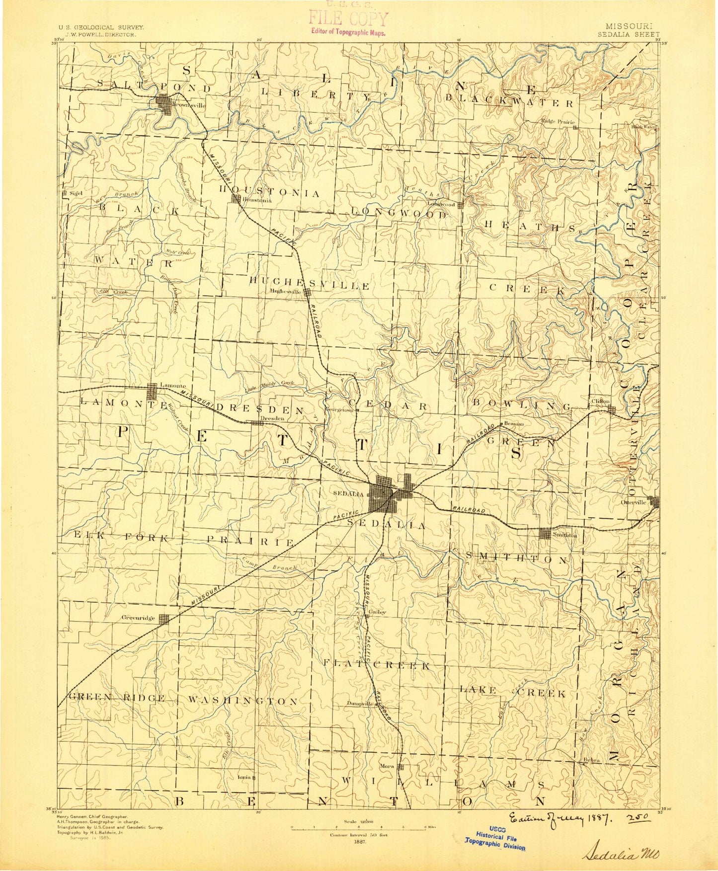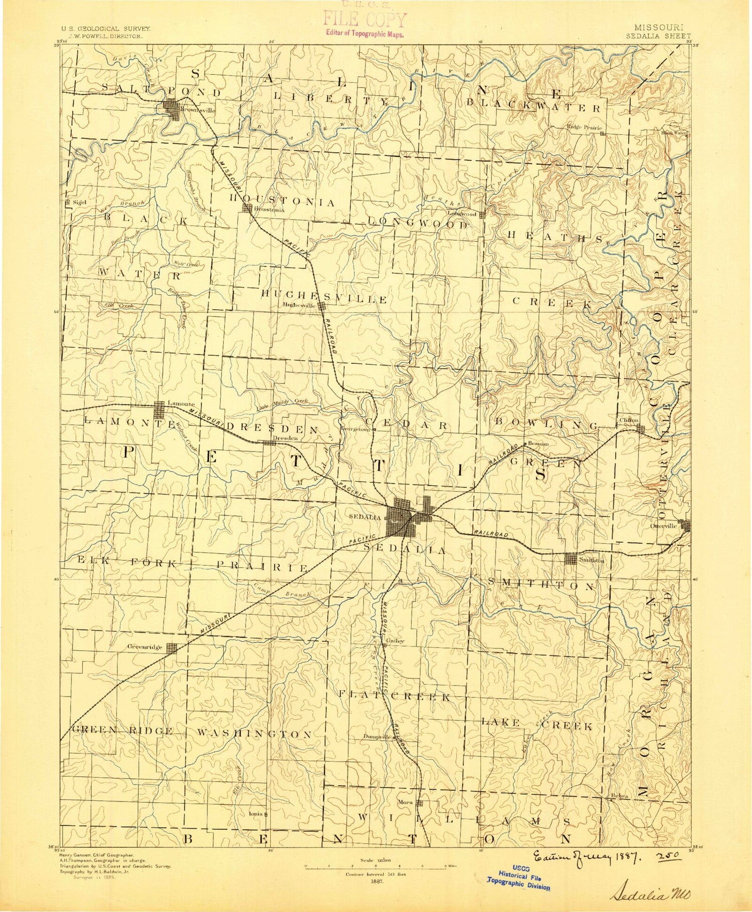
MyTopo
Historic 1887 Sedalia Missouri 30'x30' Topo Map
Couldn't load pickup availability
Historical USGS topographic map of Sedalia in the state of Missouri. Scale: 1:125000. Print size: 17" x 24"
This map was published in 1887 and is in the following counties: Benton, Cooper, Johnson, Lafayette, Morgan, Pettis, Saline.
The map contains contour lines, roads, rivers, towns, streams, and lakes. Printed on high-quality waterproof paper with UV fade-resistant inks.
Contains the following named places: Anderson Branch, Bahner, Basin Fork, Bear Branch, Bee Branch, Bee Branch, Bradford Roadside Park, Breakfast Branch, Brushy Creek, Brushy Creek, Brushy Creek, Brushy Creek, Buck Branch, Buffalo Creek, Buncomb Branch, Camp Branch, Camp Branch, Campbell Siding, Centennial Park, Cheese Creek, Clear Branch, Clear Creek, Coon Creek, Coppers Creek, Coppers Hill, Covered Bridge Park, Davis Creek, Dresden, Dry Creek, East Elk Fork, Elk Branch, Elk Creek, Elm Fork, Embry Lake, Emma, Finney Creek, Georgetown, Goose Creek, Goose Lake, Grassy Creek, Greer Branch, Harlan Branch, Harpers Branch, Haw Creek, Heaths Creek, Henry Creek, Hess Creek, Horseshoe Lake, Houstonia, Howard Park, Howsel Park, Hubbard Park, Hughesville, Ionia, Johnson Branch, Jordan Creek, Lake Creek, Landon Branch, Liberty Park, Little Haw Creek, Little Muddy Creek, Little Shaver Creek, Long Branch, Long Branch, Long Grove Branch, Lookout, Marlin Creek, Marshall Junction State Wildlife Area, Martin Branch, May Branch, McAllister Springs Access Point, McGee Branch, Mora, Nelson, North Flat Creek, Old Channel Davis Creek, Olive Branch, Otterville, Painter Branch, Panther Creek, Pepper Creek, Perry State Wildlife Area, Pipkin Branch, Salt Pond Creek, Sedalia Reservoir, Pearl River, Shaver Creek, Smelser Creek, South Flat Creek, South Fork Blackwater River, Spring Fork, Tebo Creek, Turkey Creek, Vermont Park, Walnut Branch, Walnut Creek, West Elk Fork, Willow Branch, Wolf Creek, Marshall Junction, McAllister Springs, Sweet Springs, Beaman, Beaverdam Creek, Cedar Creek, Dunksburg, Elk Fork, Green Ridge, Lake Creek, Longwood, Mosby Creek, Muddy Creek, Sedalia, Smithton, La Monte, State Fairground Racetrack, Tedieville, Clifton City, Bush, Brandon, Bryson, Manila, Newland, Postal, Ridge Prairie, Shackleford Crossing, Spring Fork, Stokley, Windsor Junction, Craft, Thompson Hills Shopping Center, State Fair Shopping Center, Valda, Lake of the Ozarks Planning Region, Walnut Hill Country Club, Pyrmont, Spring Fork Lake, Pettis County, Fortune Lake Dam, Fortunes Lake, Wicker Lake Dam, Raymond Wicker Lake, Parkhurst Lake Dam, Lake Lucille, Tempel Lake Dam, Tempel Lake, Hermora Lake Dam, Lake Bubida, Rubydo Lake Dam, Hermora Lake, City of Sweet Springs Dam B, City Reservoir B, City of Sweet Springs Dam A, City Reservoir A, Smith Lake Dam, Weston Lake Dam, Alcolac Lake Dam, Lake Alcolac, Frederick Lake Dam, Spring Fork Lake Dam, Knight Lake Dam, Number 130 Reservoir, Tebo Lake Dam, Lake Tebo, Rader Lake Dam, Marvin Howard Lake, Dick Monsees Dam, Monsees Lake, Wesner Lake Dam, Dickman Lake Dam, Dilthey Lake Dam, Hughes Lake Dam, Steve Smith Lake Dam, Steele Lake Dam, Daum Lake Dam, Selken Lake Dam, Township of Blackwater, Township of Otterville, Township of Blackwater, Township of Bowling Green, Township of Cedar, Township of Dresden, Township of Elk Fork, Township of Flat Creek, Township of Green Ridge, Township of Heath Creek, Township of Houstonia, Township of Hughesville, Township of Lake Creek, Township of La Monte, Township of Longwood, Township of Prairie, Township of Sedalia, Township of Smithton, Township of Washington, Township of Blackwater, Township of Liberty, Township of Salt Pond, City of Houstonia, City of Emma, City of Green Ridge, City of Nelson, City of La Monte, City of Smithton, City of Sweet Springs, City of Otterville, City of Sedalia, Town of Ionia, Village of Hughesville, North Branch Pearl River