MyTopo
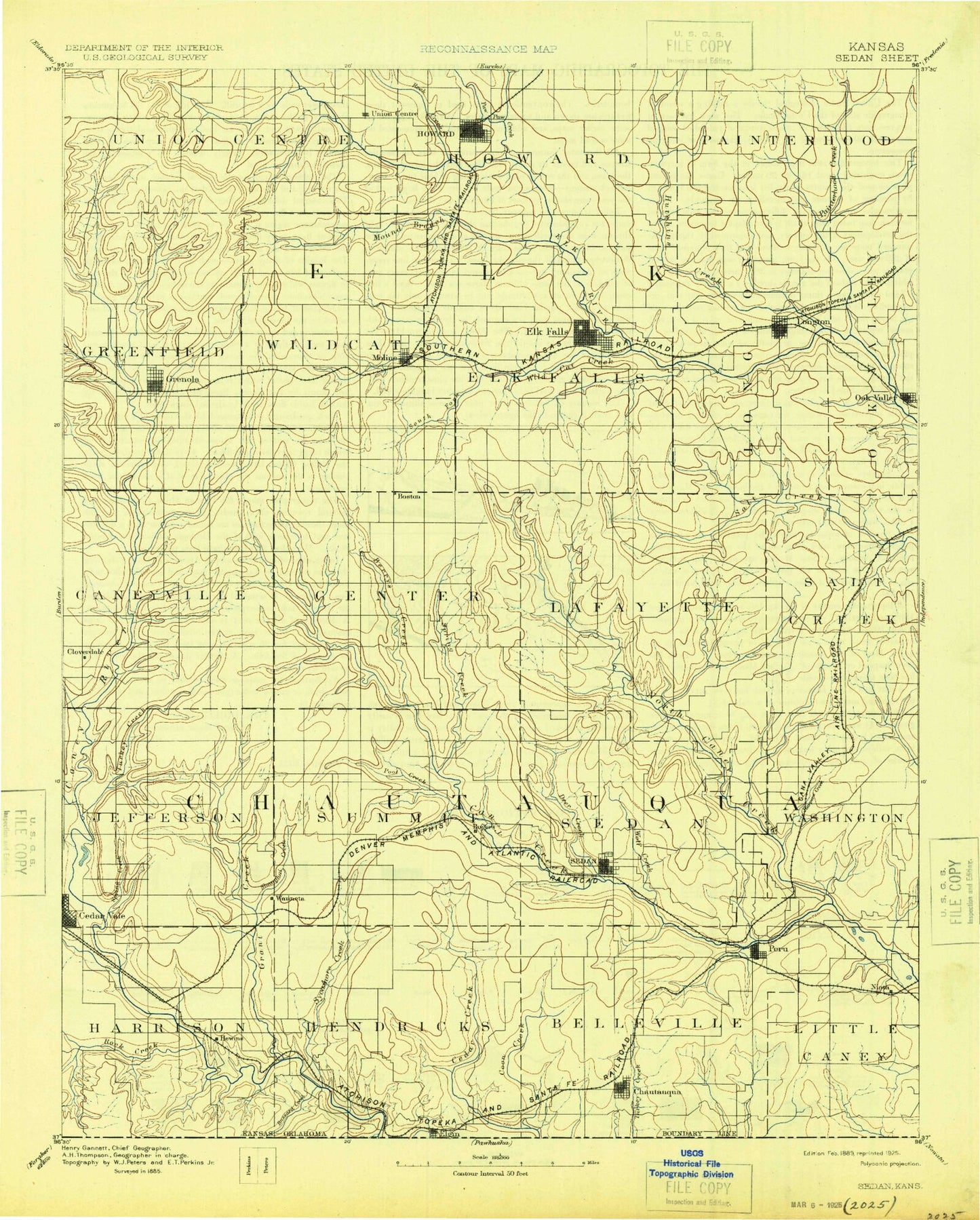
Historic 1889 Sedan Kansas 30'x30' Topo Map
Couldn't load pickup availability
Historical USGS topographic map of Sedanin the states of Kansas, Oklahoma. Scale: 1:125000. Print size: 17" x 24"
This map was published in 1889 and is in the following counties: Chautauqua, Elk.
The map contains contour lines, roads, rivers, towns, streams, and lakes. Printed on high-quality waterproof paper with UV fade-resistant inks.
Contains the following named places: Rock Creek, Dry Creek, Osro Falls, Shanghai Creek, Hewins Park, Spring Branch, West Branch Grant Creek, East Branch Grant Creek, Grant Creek, Township of Harrison, Township of Jefferson, Cedar Creek, Sycamore Creek, West Cedar Creek, Buzzard Creek, Elgin, Little Cedar Creek, Rock Creek, Possum Trot Creek, Township of Summit, Township of Hendricks, Township of Washington, Otter Creek, Township of Little Caney, Peru, Niotaze, Niotaze Lake, Davis Creek, Niotaze Oil Field, Sedan, Deer Creek, Township of Sedan, Wolf Creek, Chautauqua, Middle Caney Creek, Possum Trot Creek, Harper Creek, Turkey Creek, Otter Creek, Union Creek, Squaw Creek, Pool Creek, Butcher Falls, Spring Creek, Bakers Branch, Sedan City Lake, Coon Creek, Turkey Creek, Tanglewood Lake, Quivira Camp, Possum Creek, Township of Center, Fly Creek, Deadman Creek, Broker Creek, Township of Lafayette, Bachelor Creek, Coffey Branch, Township of Salt Creek, McCoy Ranch, Longton, Oak Valley, Bloody Run, Pan Creek, Little Hickory Creek, Hickory Creek, Township of Oak Valley, South Salt Creek, Elk Falls, Township of Longton, Clear Creek, North Salt Creek, Township of Elk Falls, Moline, Santa Fe Lake, Wildcat Creek, North Fork Wildcat Creek, South Fork Wildcat Creek, Grenola, Township of Wildcat, Wolf Creek, Corum Creek, East Fork Caney River, Schrader Branch, Spring Creek, Township of Greenfield, Skull Creek, Perkins Oil Field, Ware Oil Field, Bush-Denton Oil Field, East Eagle Head Ranch, West Eagle Head Ranch, Love Oil Field, Dunkleberger Oil Field, Howard, Rock Creek, Clear Creek, Bull Creek, Township of Howard, Polk Daniels Lake, Snake Creek, Pawpaw Creek, Game Creek, Mound Branch, West Hitchen Creek, Longton Oil and Gas Field, Mid Painterhood Creek, East Hitchen Creek, Painterhood Creek, West Painterhood Creek, East Painterhood Creek, Little Hitchen Creek, Township of Painterhood, Hitchen Creek, Township of Belleville, Hulah Wildlife Area, Sedan City Dam, Moline City Dam, Santa Fe Lake Dam, Chautauqua Hills, Elk County Fairgrounds, Spring Creek, Mantansas, Bear Creek, Wauneta, Layton, Osro, Hewins, Cloverdale, Gibbs, Rogers, Grafton, Monett, Hale, Busby, Osage Cuestas, Chautauqua County, Elk County, North Caney Creek, Township of Caneyville, City of Chautauqua, City of Grenola, City of Howard, City of Elgin, City of Elk Falls, City of Niotaze, City of Moline, City of Longton, City of Peru, City of Sedan, Sedan Wastewater Treatment Facility, Chautauqua Wastewater Plant, Howard Wastewater Treatment Facility, Moline Wastewater Treatment Facility, Longton Sewer Treatment Plant, Chautauqua County Fairgrounds, Elk County Rodeo Association, Longton City Fairgrounds, Cedar Vale Wastewater Treatment Plant, Grenola Wastewater Plant, Peru Wastewater Plant, Sedan Country Club, Sedan Farm Supply Grain Elevator Number 1, Buzzard Creek, Possum Trot Creek, Chautauqua Hills