MyTopo
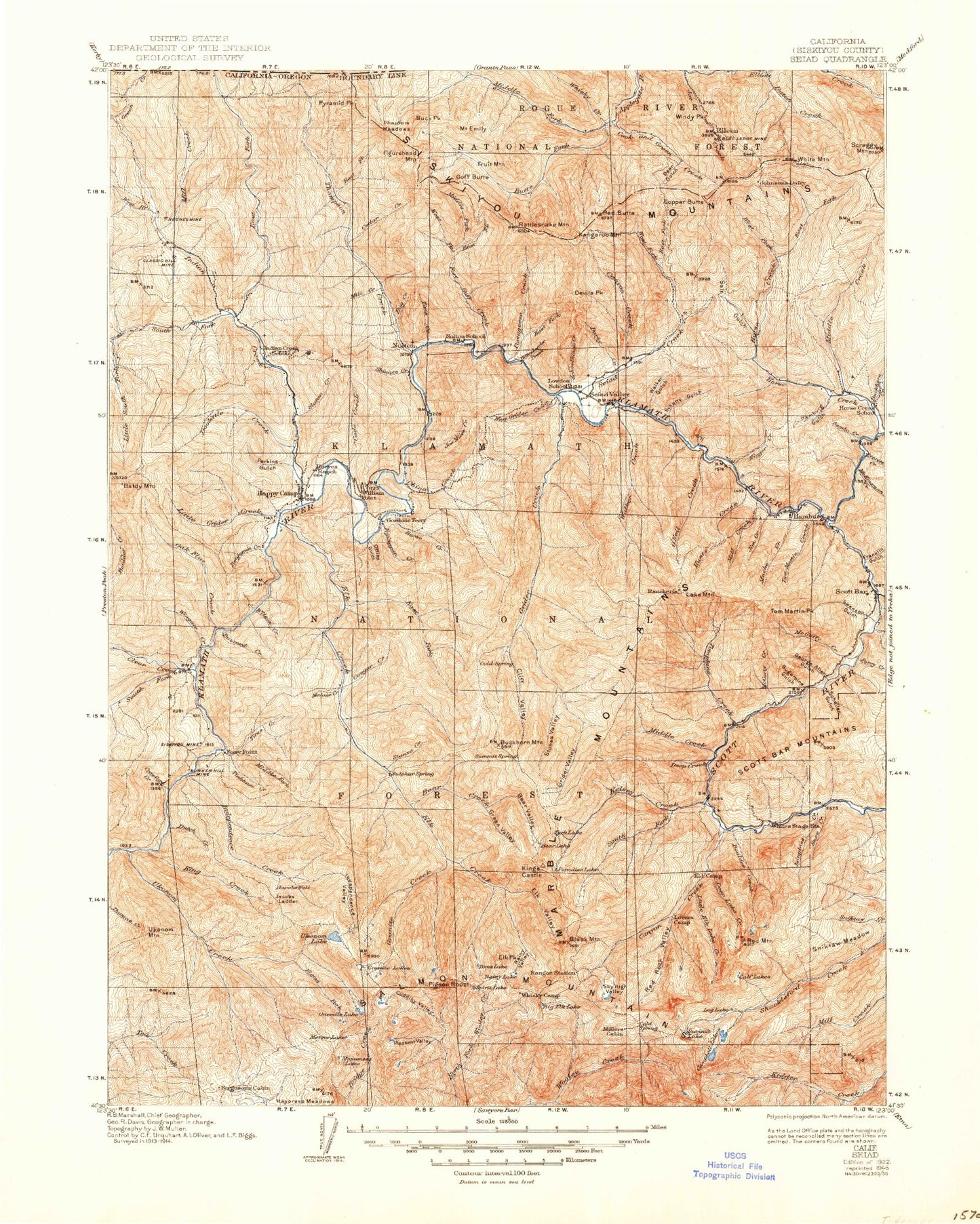
Historic 1922 Seiad California 30'x30' Topo Map
Couldn't load pickup availability
Historical USGS topographic map of Seiad in the state of California. Scale: 1:125000. Print size: 17" x 24"
This map was published in 1922 and is in the following counties: Josephine, Siskiyou.
The map contains contour lines, roads, rivers, towns, streams, and lakes. Printed on high-quality waterproof paper with UV fade-resistant inks.
Contains the following named places: Bark Shanty Creek, Beauty Flat, Big Ferry Creek, Bittenbender Creek, Blue Granite Lake, Blue Mountain, Boulder Creek, Bridge Flat, Buns Basin, Burney Lake, Burney Valley Creek, Cade Creek, Cade Mountain, Canyon Creek, Canyon Creek, Caroline Creek, Cedar Flat Cabin, China Creek, China Creek Mine, China Peak, China Point, Coon Creek, Cub Creek, Cuddihy Fork, Cuddihy Lakes, Cuddihy Valley, Darkey Creek, Deadman Lake, Deep Creek, East Fork Portuguese Creek, Flems Fork, Fort Goff Creek, Fourmile Creek, Franks Valley, Fryingpan Creek, Fryingpan Ridge, George Allen Gulch, Gold Flat, Gold Granite Lake, Granite Creek, Green Granite Lake, Grey Eagle Mine, Grider Creek, Haypress Meadows, Hells Meadows, Hooligan Lake, Horse Creek, Horse Pocket, Hummingbird Creek, Independence Lake, Independence Valley, Jacobs Ladder, Jawbone Camp, Joe Miles Creek, Johnsons Hunting Ground, Kelsey Camp, Kelsey Creek, King Creek, Ladds Creek, Lick Creek, Lightning Gulch, Little Ferry Creek, Marble Valley, McCarthy Creek, McCash Fork, McCash Lake, McGuffy Creek, Meteor Lake, Middle Creek, Middle Creek Camp, Mill Creek, Monument Lake, Morgan Point, Muck a Muck Mine, Mule Pocket, Nolton, Oak Hollow Creek, Onemile Lake, Ottley Gulch, Panther Cove, Panther Creek, Pat Ford Creek, Pickle Camp, Pleasant Lake, Pleasant Valley, Portuguese Creek, Ranch Gulch, Reeves Mine, Richardson Bedrock Mine, Rocky Bar Campground, Round Meadows, Salt Creek, Sandy Ridge, Sawmill Gulch, Schoolhouse Creek, Scott Bar Pond, Seattle Creek, Secret Lake, Secret Valley, Seiad Creek, Seiad Valley, Seiad Valley, Slater Butte, Slinkard Peak, Smith Fork, Schutts Gulch, Snow Creek, Snyder Lake, South Fork China Creek, South Fork Pat Ford Creek, Spirit Lake, Stein Gulch, Sugarpine Gulch, Swanson Gulch, Ten Bear Mountain, Three Biscuit Gulch, Ti Creek Meadows, Tickner Hole, Tickner Lake, Tims Creek, Tom Martin Peak, Tompkins Creek, Toms Lake, Toms Valley Creek, Townsend Gulch, Ukonom Creek, Ukonom Lake, Ukonom Mountain, Walker Creek, Walker Gulch, West Grider Creek, Williams Gulch, Williams Point, Wolf Creek, Woods Bar, Wooliver Creek, Horsetail Falls, Shinar Saddle, Seiad Low Gap, No Name Creek, Louie Creek, Bill Berry Creek, Schuler Gulch, Isinglass Creek, Onemile Creek, Thompson Creek, Tickner Creek, Woods Creek, Alder Gulch, Ananias Camp, Angel Lake, Anthony Milne Camp, Aspen Lake, Azalea Lake, Babs Fork, Baileys Cabin, Baker Gulch, Bald Hornet Creek, Baldy Mountain Ridge, Baldy Mountain, Bare Mountain, Bean Gulch, Bear Creek, Bear Gulch, Bear Gulch, Bear Lake, Bear Valley, Bear Valley Creek, Bear Wallow Camp, Benjamin Creek, Big Camp, Big Elk Fork, Big Elk Lake, Big Meadows, Big Meadows Creek, Big Rock Camp, Big Rock Fork, Bill Fruit Trail, Bishop Creek, Back Meadows, Back Meadows Creek, Black Marble Mountain, Blue Bar Mine, Blue Ledge Mine, Boulder Peak, Box Camp, Browns Creek, Buck Peak, Buckhorn Creek, Buckhorn Creek, Buckhorn Lake, Buckhorn Mountain, Bug Creek, Bunker Hill Mine, Butte Fork Applegate River, Buzzard Creek, Buzzard Lake, Calf Lake, Cameron Meadow, Cameron Meadows, Camp Gulch, Campbell Lake, Cayenne Ridge, Cedar Basin, Cedar Creek, Chinquapin Lake, City Gulch, Classic Hill Mine, Clauson Creek, Clear Creek, Cliff Lake, Cliff Valley, Cole Creek, Cook and Green Campground, Cook and Green Creek, Cook and Green Pass, Coon Hollow, Coon Run, Copper Butte, Copper Creek, Cougar Creek, County Mine, Crawfish Gulch, Crawford Creek, Curley Jack Campground, Curley Jack Creek, Dads Pocket, Daggett Creek, Death Valley, Death Valley Creek, Deep Lake, Deep Lake Creek, Deer Lick Creek, Des Moines Creek, Desolation Gulch, Dogwood Lake