
MyTopo
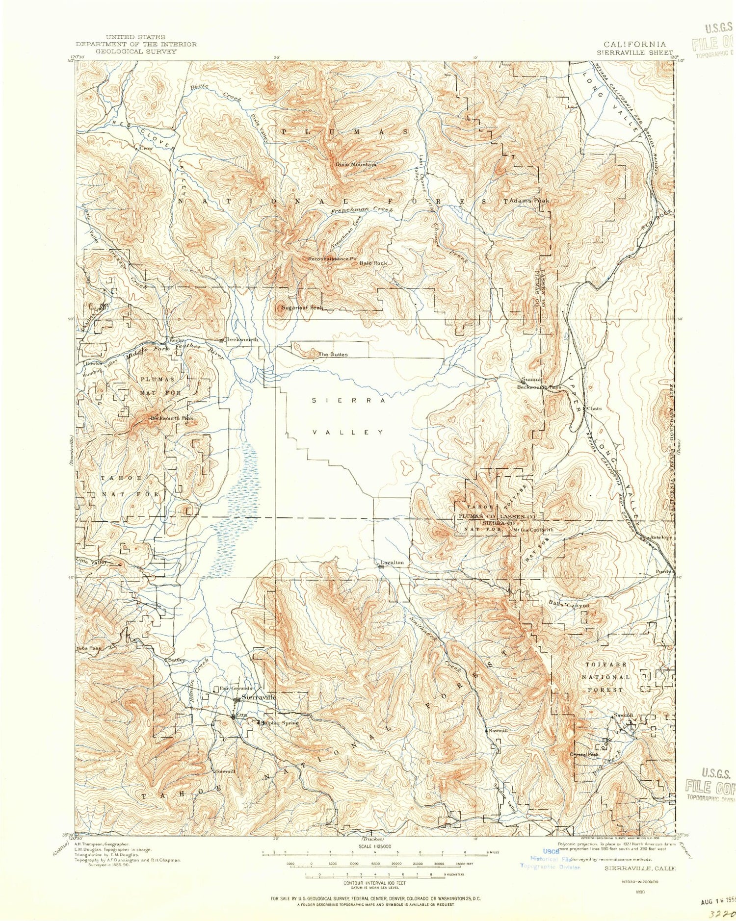
Historic 1890 Sierraville California 30'x30' Topo Map
Couldn't load pickup availability
Historical USGS topographic map of Sierraville in the state of California. Scale: 1:125000. Print size: 17" x 24"
This map was published in 1890 and is in the following counties: Lassen, Plumas, Sierra, Washoe.
The map contains contour lines, roads, rivers, towns, streams, and lakes. Printed on high-quality waterproof paper with UV fade-resistant inks.
Contains the following named places: Ahart Camp, Alder Creek, Bald Rock, Bear Valley, Big Canyon, Blatchley Canyon, Canyon Ranch, Church Camp, Coburn Lake, Cold Creek Campground, Cold Stream, Cottonwood Creek, Dark Canyon, Dark Canyon, Dark Canyon Trail, Dixie Valley, Dotta Canyon, Dotta Saddle, Dry Flat Trail, Dry Valley, Franklin Cabin, Groundhog Rock, Hamlin Creek, Harding Point, Henness Pass, Independence Creek, Kyburz Flat, Lemon Canyon, Lewis Mill Station, Little Last Chance Lake, Maiden Valley, Nichols Mill, Onion Valley, Randolph Hill, Rice Canyon, Rock Creek, Sardine Peak, Sardine Point, Sattley, Sierraville, Smithneck Creek, Onion Creek, Table Rock, The Buttes, The Mounds, Treasure Mountain, Trosi Canyon, Turner Canyon, Wheelers Sheep Camp, Lake of The Woods, Yuba Pass, Bonta Saddle, Jammer Chair Flat, Sugar Loaf, Berry Creek, Bonta Creek, Reconnaissance Peak, Dyson Slough, Adams Neck, Adams Peak, Antelope Mine, Antelope Valley, Babbitt Peak, Badenaugh Canyon, Bald Mountain Range, Balls Canyon, Balls Ranch, Bear Valley Creek, Beckwourth Pass, Beckwourth Peak, Big Cove Campground, Big Grizzly Creek, Bloomer Lake, Burma Summit, Burnham Meadow, Calpine, Camp Dixie, Carman Creek, Carman Saddle, Carman Valley, Cat Canyon, Charles Valley, Charles Valley Creek, Chilcoot Campground, Chilcoot Tunnel, Clover Valley Ranch, Clover Valley Ranch, Correca Canyon, Cottonwood Spring Campground, Coulee Canyon, Coyote Hills, Crocker Creek, Crocker Guard Station, Crocker Meadow, Crocker Mountain, Crystal Peak, Crystal Peak Guard Station, Dan Blough Cove, Dinwiddie Arm, Dixie Creek, Dodge Canyon, Dog Valley, Dog Valley Guard Station, Donkey Canyon, Dooley Canyon, Dotta Neck, Eagles Peak Ski Area, East Fork Carman Creek, Elephants Head, Evans Canyon, Flying Dutchman Mine, Frenchman Campground, Frenchman Creek, Frenchman Dam, Frenchman Lake, Galeppi Cattle Trail, Galeppi Creek, Grasshopper Flat Campground, Grigsby Camp, Grigsby Creek, Grizzly Campground, Grizzly Ice Pond, Grizzly Valley, Grizzly Valley Dam, Guzzier, Haskell Peak, Horton Canyon, Horton Ridge, Humbug Valley, Mount Ina Coolbrith, Jones Valley, Lawton Meadow, Little Dooley Creek, Little Haskell Peak, Little Last Chance Creek, Lombardi Point, Long Canyon, Lookout Creek, Mapes Canyon, McNair Meadow, McPherrin Camp, McReynolds Valley, Merrill Creek, Merrill Valley, Mitchell Canyon, North Channel Little Last Chance Creek, North Fork Ramelli Creek, Palen Reservoir, Purdy Creek, Ramelli Creek, Red Rock, Red Rock Canyon, Rhodes Creek, Rice Hill, Ross Canyon, Ross Ranch Meadow, Sardine Valley, Sierra Valley, Sierra Valley Channels, Frenchman Cove, Haskell Peak Trail, Martin Neck Canyon, Roberts Canyon, Snow Lake, South Branch Dog Creek, South Fork Ramelli Creek, Spring Creek, Spring Creek Campground, State Game Refuge One-P, Summit, Thompson Valley, Trosi Canyon, Trosi Canyon Ranch, Turner Canyon, Upper Long Valley, West Fork Carman Creek, Whiskey Canyon, Winnie Smith Mill, Yellow Rock, Crystal Peak Campground, Hunting Camp Number Four, Dog Valley Campground, Hunting Camp Number Two, Davies Creek Campground, Balls Canyon Hunting Club, Long Valley Mill, Plumas, Turkey Point, Crystal Vista, Davis Roadside Rest, Ramelli Ranch, Little Last Chance Canyon Special Interest Area, Grasshopper Flat, Sierraville Ranger Station, Deer Lake Trail, Bear Valley Campground, Cottonwood Overlook Trail, Cottonwood Fisherman Trail, Cottonwood Botanical Trail, Yubas Pass Campground, Loyalton, Donner Trail, Dry Valley Creek, East Channel Little Last Chance Creek, Squaw Valley, Lunker Point, Crystal, Frenchman Forest Service, Chilcoot, Crystal Peak, Dixie Mountain, Omira, Peavine, Vinton, Beckwourth, Campbell Hot Springs, Delleker, Hallelujah Junction, Hawley, Portola, Randolph, Reno Junction, Rocky Point, Scotts, Old Fish Farm, Purdy, Franklin Cabin, Grizzly Creek 285 Dam, Palen 290 Dam, Aldabe 291 Dam, Sunrise 1290 Dam, Folchi Meadows, McElroy Hill, Beacon Point, Bear Flat, Calpine Reservoir


