
MyTopo
Historic 1894 Silver City Idaho 30'x30' Topo Map
Couldn't load pickup availability
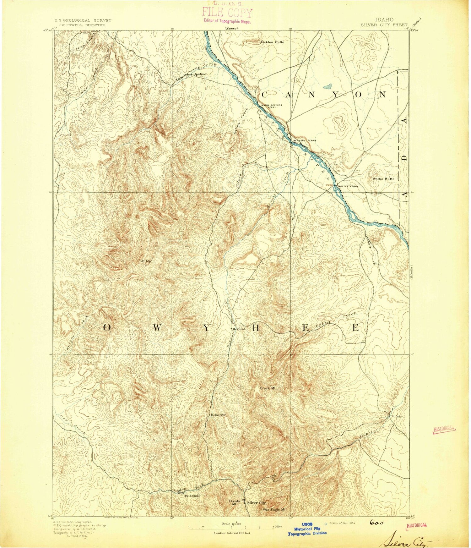
Historical USGS topographic map of Silver City in the state of Idaho. Scale: 1:125000. Print size: 17" x 24"
This map was published in 1894 and is in the following counties: Ada, Canyon, Owyhee.
The map contains contour lines, roads, rivers, towns, streams, and lakes. Printed on high-quality waterproof paper with UV fade-resistant inks.
Contains the following named places: Alkali Creek, Alkali Draw, Alta Mine, Avondale Basin, Babbington Creek, Banner Mine, Bare Hill, Barth Lateral, Baxter Basin, Bennett Lateral, Bernard Wasteway, Big Pass Reservoir, Black Jack Mine, Black Mountain, Blackrock Gulch, Blacksmith Gulch, Blue Gulch, Bluejacket Mine, Bluff Lateral, Booneville Gulch, Briar Creek, Bridge Creek, Brooks Lateral, Brunzell Mine, Bull Frame Creek, Bull Frame Reservoirs, Bull Meadow, Bush Ranch, Butte Lateral, Canter Spring Reservoir, Cape Horn Mine, Captain Butte, Cemetery Gulch, Chariot Gulch, Chimney Pot Reservoir, China Creek, China Flat, China Gulch, Coal Bank, Coe Lateral, Cold Spring Creek, Cosmopolitan Creek, Cottle Creek, Cottle Lake, Cottonwood Creek, Coulee Drain, Coyote Creek, Crane Creek, Crows Nest, Crows Nest Creek, Cumberland Gulch, Cunningham Creek, Deadhorse Canyon, Dewey Mine, Diamond Basin, Diamond Creek, Dobson Creek, Dryden Creek, Dryden Peak, Dryden Reservoir, East Fork Reynolds Creek, East Fork Squaw Creek, East Madden Lateral, East Railroad Lateral, Erdman Mine, Farrot Creek, Figure Four Creek, Flatiron Ridge, Flattop Butte, Flume Lateral, French Gulch, French John Hill, Gardner Gulch, Garfield Mine, Garland Drain, Getaway Mountain, Ghost Ranch, Glass Hill, Golden Cycle Mine, Granite Creek, Gray Eagle Creek, Grouch Drain, Hamilton Gulch, Hardtrigger Creek, Henrietta Mine, Horse Race Ridge, Horse Ranch Creek, Ida Belle Mine, Jacks Creek, Jackson Creek, Jackson Gulch, Jacobs Gulch, Jensen Lake, Jinx Lateral, Johnston Draw, Johnston Lakes, Jump Creek Canyon, Jump Creek Falls, Last Chance Gulch, Lemberg Lateral, Leviathan Gulch, Linehan Flat, Little Cottonwood Creek, Little Cow Creek, Little Hardtrigger Creek, Little Jackson Creek, Little McBride Creek, Little Poison Creek, Little Squaw Creek, Little Succor Creek, Long Draw, Macks Creek, Mahogany Gulch, Martin Lateral, Matteson Mine, Maws Gulch, Melba Drain, Middle Fork Hardtrigger Creek, Midway Lateral, Monarca Mine, Morning Star Mine, Moss Flat, Murphy, Murphy Creek, Murphy Rim, Nancy Gulch, Negro Gulch, New York Summit, Newsome Gulch, North Fork Macks Creek, North Fork Peters Gulch, North McElroy Lateral, North Power Lateral, North Sinker Flat, Opalene Ditch, Opalene Gulch, Oro Fino Gulch, Oro Fino Mine, Pass Lateral, Peters Gulch, Piute Butte, Placer Mine, Pole Creek, Pole Creek, Poorman Mine, Posey Creek, Presby Creek, Rabbit Creek, Rats Nest Gulch, Reynolds Creek, Rich Gulch, Rippee Island, Rock Spur Drain, Rodeo Gulch, Rooster Comb Peak, Sage Hen Gulch, Salmon Creek, Sand Canyon, Sands Basin, Sawpit Gulch, Scotch Bob Creek, Shares Basin, Sheep Creek, Sinker Canyon, Sinker Tunnel, Slacks Mountain, Slaughterhouse Gulch, Slaughterhouse Gulch, Sleepy Hollow Drain, Soda Creek, Soldier Cap, Sommercamp Basin, South Fork Macks Creek, South Power Lateral, Spain Hill, Squaw Butte, Stewart Gulch, Striker Basin, Striker Basin Gulch, Summit Mine, Summitt Lateral, Chimney Creek, Swisher Ridge, Table Rock, Tennessee Gulch, Tennessee Mountain, Texas Basin, Tiddie Creek, Tims Peak, Tip Top Mine, Trade Dollar Mine, Upper Deer Flat, Venus Mine, Waldvogel Canal, Waldvogel Canal Wasteway, Walters Butte Lateral, War Eagle Mountain, Webfoot Gulch, West Fork Reynolds Creek, West Fork Sinker Creek, West Fork Squaw Creek, West Madden Lateral, Whiskey Mountain, Whizzer Lateral, Wildcat Canyon, Wildcat Canyon, Willard Lateral, Willow Fork, Wilson Bluff, Wilson Creek, Winchester Gulch, Windy Point, Wood Road Gulch, De Lamar Mine, Humboldt Mine, Idaho Mine, Lobe Mine, Slacks Creek, SW Gate Gulch Reservoir, North De Lamar Pit, South Fork Diamond Creek, Half Moon Gulch, Drollinger Ridge, Peters Point, Nugent Meadows, Johnson Gulch, Cavaney Hill, Bald Mountain, Picnic Gulch, China Point, Potosi Ridge, Succor Creek Reservoir, Melmont, Bernard Ditch, Con Shea Basin, Dilley Island


