MyTopo
Historic 1898 Silver Peak Nevada 30'x30' Topo Map
Couldn't load pickup availability
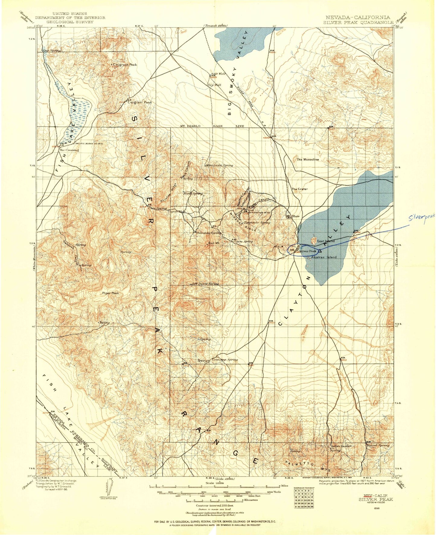
Historical USGS topographic map of Silver Peakin the states of Nevada, California. Scale: 1:125000. Print size: 17" x 24"
This map was published in 1898 and is in the following counties: Esmeralda, Mono.
The map contains contour lines, roads, rivers, towns, streams, and lakes. Printed on high-quality waterproof paper with UV fade-resistant inks.
Contains the following named places: Fish Lake Valley, Fish Lake Valley Wash, Argentite Canyon, Black Canyon, Eagle Canyon, Echo Canyon, Emigrant Pass, Emigrant Peak, Fish Lake Valley Wash, Goat Island, Lida Wash, Lookout Mine, McAfee Canyon, McNamara Mine, Mineral Ridge, Mohawk Mine, New York Canyon, Nivloc Mine, Oasis Divide, Rhyolite Ridge, Sheep Flat, Sugar Peak, The Monocline, White Wolf Canyon, Piper Peak, Silver Peak Range, Angel Island, Silver Peak, Weepah Hills, Last Chance Mine, Red Mountain, Sheep Mountain, Vanderbilt Peak, Heavy Rock Mine, Good Hope Mine, Darms Mine, Sixteen-To-One Mine, Imperial Mine, Birch Creek, North Star Mine, Coyote Summit, Weepah Mine, Oro Monte Mine, Drinkwater Mine, Custer Gulch, Great Gulch, Galena Flats, Vanderbilt Mine, Eagle Nest Canyon, Alum Mine, Indian Garden, Nivloc, Swiftwater, Harlans Peak, Harvey Peak, Silver Peak, Jims Peak, Pearsons Peak, Palmetto Peak, Esmeralda County Yard, Crown Mill, Ebley Tunnel, Silver Peak Pond, Cottonwood Canyon, Electric Gold Mines, Weepah Combination Mines, Weepah United Mines, The Wee Pah Lookout Mines, Weepah Metals Corporation Mines, Weepah Gold Mines Company Mines, Weepah Development and Mines Company Mines, Weepah Electric Extension Gold Mining Company Mines, Weepah Diamond Gold Mining Company Mines, Weepah Horton Junior Gold Mines Company Mines, United Weepah and Western Mines Corporation Mines, Weepah Discovery Gold Mines Company Mines, Weepah Nevada Mining Company Mines, Silver Peak and Red Mountain Gold, Blair Lodes, Clayton Playa Mine, Columbus Mine, Crescent Mine, Custom Mine, Double Eagle Mine, Esmeralda Mine, Frank Number Two Mine, Glory Mine, Missouri Mine, Plymouth Mine, Vega Mine, April Mine, Great Gulch Mine, Homesake Mine, Pocotillo Mine, Western Soldier Mine, Windypah Mining District, Gold Number One Mine, Silver Queen Mine, Black Rock Mine, Freese Gold Mine, Gold Hill Mine, Pocatello Mine, Good Hope Mining District, Inman Group Mine, Silver Peak Marsh Mining District, American Mine, Jet Mine, Alum Mining District, Blanco Mine, Fish Lake Marsh Mining District, Coaldale Mining District, Gap Strike Mine, Big Three Mine, Palmetto Electric Substation, Alcatraz Island, Icehouse Canyon, The Crater, Sanger Mine, Blair, Coyote Hole, The Crossing, Weepah, Clayton Valley, Weepah Mining District, Fish Lake Valley Marsh, Mohawk Alpine Mine, Valcada Mine, Pittsburg Silver Peak Mines, Crowning Glory Mine, Lodi Mine, Tiger Mine, Wood Yard, Silver Peak Mining District, Esmeralda Township, Silver Peak Marsh, Esmeralda County, Big Smoky Valley, Piper Canyon, Rock Creek, Silver Peak Division, Fish Lake Valley, Fish Lake Valley Wash, Indian Garden Creek, Fish Lake Valley Wash