MyTopo
Historic 1942 Silvertip Montana 30'x30' Topo Map
Couldn't load pickup availability
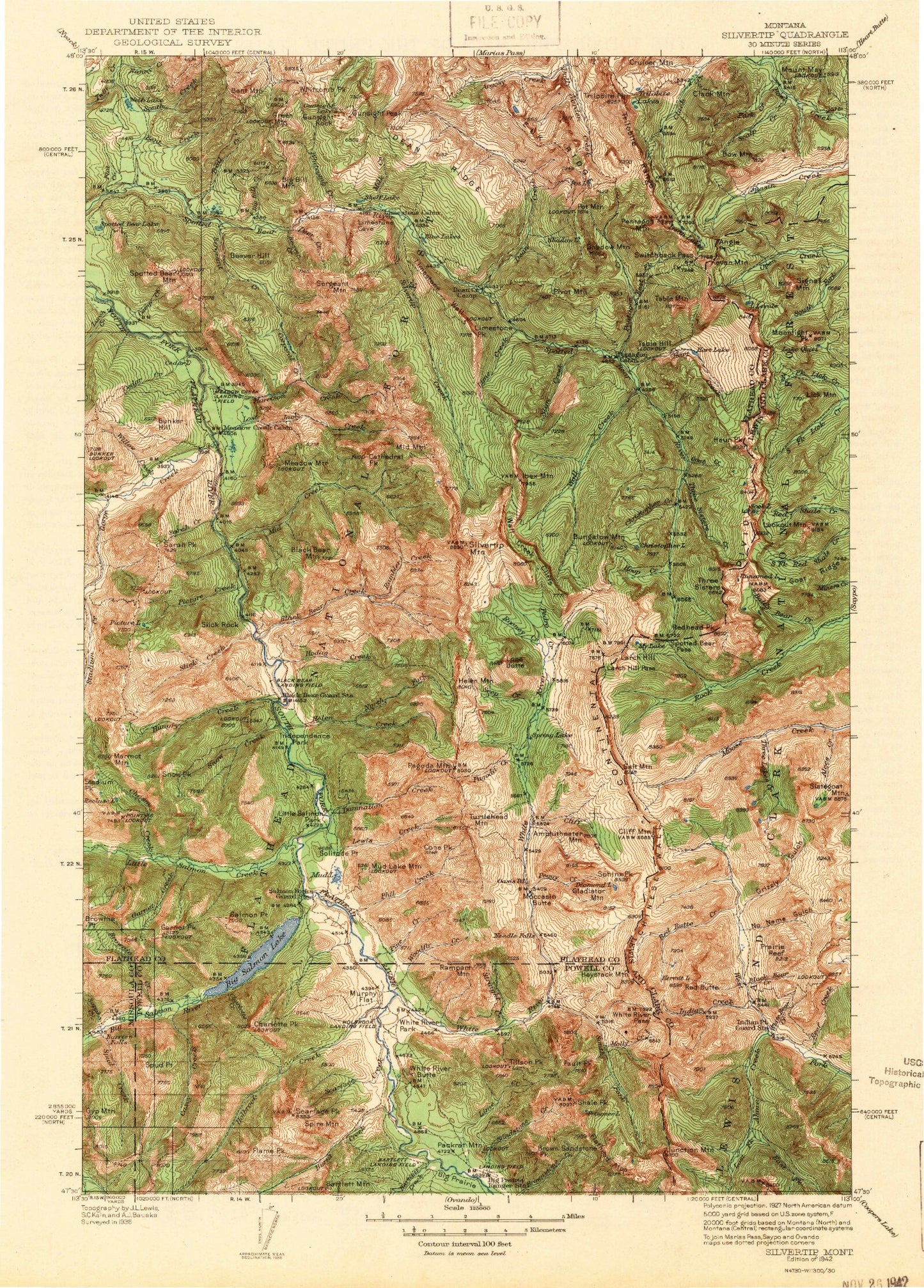
Historical USGS topographic map of Silvertip in the state of Montana. Scale: 1:125000. Print size: 15" x 24"
This map was published in 1942 and is in the following counties: Flathead, Lewis and Clark, Missoula, Powell.
The map contains contour lines, roads, rivers, towns, streams, and lakes. Printed on high-quality waterproof paper with UV fade-resistant inks.
Contains the following named places: Deer Creek, Three Sisters Creek, Flat Creek, Spotted Bear River Trail, Amphitheatre Mountain, Argosy Creek, Barrier Falls, Bartlett Creek, Bartlett Mountain, Beaver Creek, Beaver Hill, Bent Creek, Bent Mountain, Big Bill Creek, Big Bill Mountain, Big Salmon Creek, Big Salmon Lake, Black Bear Creek, Black Bear Guard Station, Black Bear Hump, Black Bear Mountain, Blue Lakes, Bow Mountain, Bowl Creek, Bowl Divide Trail, Brown Sandstone Peak, Brownie Creek, Brownie Point, Brushy Park, Bungalow Lookout Trail, Bungalow Mountain, Bunker Creek, Bunker Hill, Bunker Park, Burnt Creek, Casey Creek, Cathedral Peak, Cedar Creek, Chair Mountain Trail, Charlotte Creek, Charlotte Peak, Chasm Creek, Christopher Creek, Christopher Lake, Clack Mountain, Cliff Creek, Cone Peak, Corporal Creek, Cruiser Mountain, Damnation Creek, Dean Creek, Dean Creek Campsite, Dean Falls, Dean Lake, Dean Ridge, Dean Ridge, Diamond Lake, East Fork Pentagon Creek, Elk Ridge, Fault Peak, Feather Creek, Flame Peak, Flathead Alps, Garnet Creek, Garnet Peak, Gladiator Mountain, Goat Creek, Gorge Creek, Green Mountain, Green Mountain Trail, Grizzly Park, Gunsight Lake, Gunsight Peak, Gunsight Rock, Gunsight Trail, Gyp Mountain, Hammer Creek, Harrison Creek, Hart Creek, Hart Lake, Haystack Mountain Trail, Helen Creek, Helen Creek Trail, Helen Mountain, Henry Anderson Creek, Hodag Creek, Holbrook Creek, Hoop Creek, Hungry Creek, Ibex Mountain, Independence Park, Jungle Creek, Lamoose Creek, Larch Hill Trail, Lewis Creek, Lime Creek, Lime Creek, Limestone Peak, Limestone Wall, Little Salmon Creek, Little Salmon Park, Lone Butte, Lost Jack Creek, Marmot Mountain, Mount May, Meadow Creek, Meadow Creek Gorge, Meadow Creek Guard Station, Meadow Mountain, Mid Creek, Mid Mountain, Milk Creek, Minaret Peak, Moccasin Butte, Molly Creek, Mud Lake, Mud Lake Mountain, Murphy Flat, Nanny Creek, Needle Falls, North Fork Helen Creek, Oasis Pond, Packrat Mountain, Pagoda Creek, Pagoda Mountain, Park Creek, Patrol Point, Pedro Creek, Peggy Creek, Pentagon Clack Creek Trail, Pentagon Creek, Pentagon Mountain, Phil Creek, Picture Creek, Picture Lake, Picture Ridge, Pine Creek, Pivot Mountain, Pot Lake, Pot Mountain, Prisoner Lake, Rambler Creek, Rampart Mountain, Recluse Lake, Rooney Creek, Salmon Forks Guard Station, Salmon Point, Sandstone Creek, Sappho Creek, Sarah Creek, Sarah Peak, Scalp Creek, Scarface Creek, Scarface Peak, Seep Creek, Sergeant Creek, Sergeant Mountain, Shadow Lake, Shadow Mountain, Shale Peak, Shelf Lake, Silvertip Creek, Silvertip Mountain, Slick Creek, Slick Rock, Slim Creek, Snow Creek, Snow Peak, Solitude Point, South Creek, South Fork White River, Spire Mountain, Spotted Bear Lake, Spotted Bear Mountain, Spotted Bear Mountain Trail, Spotted Bear Schafer Trail, Spring Lake, Spud Creek, Spud Point, Spy Mountain Trail, Straight Creek, Strawberry Creek, Switchback Pass, Table Mountain, Tillson Peak, Trail Creek, Trilobite Lakes, Trilobite Peak, Trilobite Range, Turtlehead Mountain, Una Creek, Wall Creek Cliffs, Webb Lake, West Fork Schafer Creek, West Fork Wall Creek, Whitcomb Creek, Whitcomb Peak, White River, White River Butte, White River Park, White River Trail, Willow Creek, Woodfir Creek, Black Bear Forest Service, Meadow Creek Recreaton Site, Beaver Creek Campground, Holbrook Guard Station, Pendant Guard Station, Pentagon Guard Station, Silvertip Guard Station, Ahorn Creek, Alces Creek, Angle Point, Baldy Bear Creek, Black Bear Creek, Blind Fork, Burnt Creek, Chinese Wall, Chinese Wall Trail, Cliff Mountain, East Fork Ahorn Creek, Goat Ridge, Grizzly Gulch, Hahn Peak, Haystack Mountain, Hermit Lake, Indian Creek, Indian Point Guard Station, Juliet Creek, Junction Mountain, Kevan Mountain, Larch Hill, Larch Hill Pass, Lake Levale, Lick Mountain, Lookout Mountain