MyTopo
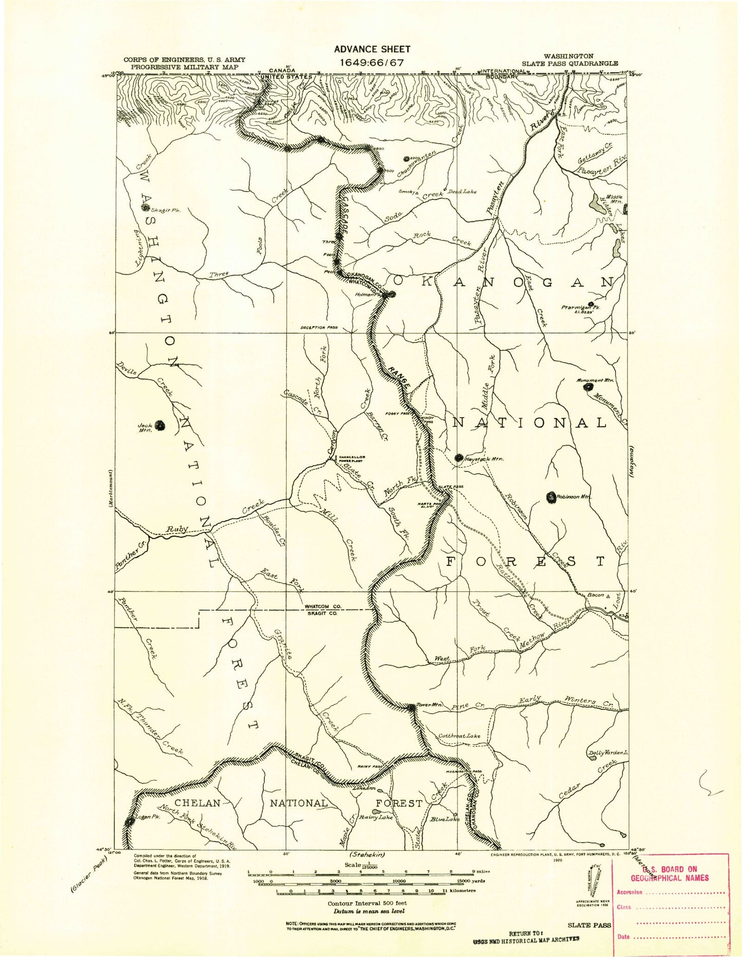
Historic 1920 Slate Pass Washington 30'x30' Topo Map
Couldn't load pickup availability
Historical USGS topographic map of Slate Pass in the state of Washington. Scale: 1:125000. Print size: 17" x 24"
This map was published in 1920 and is in the following counties: Chelan, Okanogan, Skagit, Whatcom.
The map contains contour lines, roads, rivers, towns, streams, and lakes. Printed on high-quality waterproof paper with UV fade-resistant inks.
Contains the following named places: Pacific Crest National Scenic Trail, Amey Creek, Anacortes Crossing, Ann Lake, Arralde Creek, Mount Arriva, Azurite Mine, Azurite Pass, Azurite Peak, Ballard Campground, Mount Ballard, Banded Glacier, Barron, Barron Creek, Bear Skull Shelter, Beauty Creek, Beauty Peak, Beebe Creek, Beebe Mountain, Benson Creek, Berk Creek, Big Face Creek, Big Hidden Lake, Black Peak, Blackcap Mountain, Blizzard Peak, Blue Lake, Bonita Creek, Boulder Creek, Brown Bear Camp, Brown Bear Mine, Brush Creek, Buckskin Lake, Buckskin Point, Buckskin Ridge, Buffalo Pass, Bunker Hill Creek, Burn Creek, Butte Pass, Cabinet Creek, Cache Creek, Cady Pass, Cady Point, Canyon Creek, Mountain Carru, Cascade Creek, Castle Fork, Castle Pass, Castle Peak, Cataract Creek, Cedar Crossing, Center Mountain, Central Creek, Chancellor Campground, Chuchuwanteen Cabin, Cinnamon Creek, Coney Basin, Coney Creek, Corteo Peak, Cosho Peak, County Line Creek, Crater Creek, Crater Mountain, Crow Creek, Cutthroat Creek, Cutthroat Lake, Cutthroat Pass, Cutthroat Peak, Dead Lake, Deadhorse Point, Deception Pass, Deer Fly Camp, Deer Lick Cabin, Deer Park Camp, Delancy Ridge, Devils Backbone, Devils Dome, Devils Park, Devils Park Shelter, Devils Pass, Devils Peak, Devils Stairway, Dicky Creek, Dorchester Creek, Lake Doris, Dot Lakes, Dot Mountain, Douglas Glacier, Driveway Butte, Driveway Butte Trail, Driveway Creek, Dry Creek Pass, Early Winters Spires, Early Winters Trail, East Creek, East Fork Pasayten River, Easy Pass, Easy Pass Creek, Elbow Basin, Elbow Creek, Elija Ridge, Elk Creek, Eureka Lake, Falls Creek, Farewell Creek, Ferguson Lake, Fisher Creek, Fisher Creek Basin, Fisher Pass, Fisher Peak, Flagg Mountain, Foggy Pass, Fourmile Camp, Freds Lake, Freezeout Creek, Freezeout Lake, Freezeout Mountain, Fremont Glacier, Friday Creek, Frosty Creek, Frosty Lake, Frosty Pass, Gabriel Creek, Gabriel Peak, Getaway Creek, Glacier Pass, Goat Lakes, Goat Mine, Gold Hill Mine, Gold Ridge, Golden Creek, Golden Horn, Granite Creek, Granite Creek Guard Station, Granite Pass, Grizzly Creek, Gunbarrel Camp, Handcock Ridge, Hard Scrabble Creek, Mount Hardy, Harrison Camp, Harrison Creek, Harts Pass, Haystack Mountain, Lake Hazard, Heather Lake, Heather Pass, Hells Basin, Holdover Creek, Holdover Ridge, Holliway Mountain, Holman Campground, Holman Creek, Holman Pass, Holman Peak, Holmes Creek, Honess Creek, Hopkins Lake, Hopkins Pass, Horse Heaven Camp, Horsefly Pass, Hungry Creek, Illinois Mine, Indiana Basin, Jack Mountain, Jack Mountain Trail, Jackita Ridge, Jerry Glacier, Jerry Lakes, Jet Creek, Jim Pass, Jim Peak, Joker Mountain, Judy Creek, Kangaroo Ridge, Katsuk Glacier, Katsuk Peak, Kid Creek, Kimtah Glacier, Kimtah Peak, King Creek, Kitling Creek, Kitling Lake, Kitling Peak, Mount Lago, Lake Mountain, Lakeview Ridge, Last Chance Point, Layout Camp, Leap Creek, Lease Creek, Lease Lake, Lewis Glacier, Lewis Lake, Liberty Bell Mountain, Lid Kay Camp, Lime Creek, Little Fish Shelter, Lodgepole Creek, Logan Creek, Mount Logan, Lone Buck Camp, Lost River, Lower Snowy Lake, Lunch Creek, Majestic Mountain, Martha Creek, McKay Ridge, McMillan Park, Mebee Pass, Mesahchie Glacier, Mesahchie Pass, Mesahchie Peak, Methow Pass, Middle Creek, Middle Fork Pasayten River, Midnight Creek, Mill Creek, Mill Creek Trail, Monument Peak, Mountain Home Camp, Mudhole Lake, Needle Creek, Nickol Creek, Nightmare Camp, Ninetynine Basin, Nohokomeen Glacier, North American Mine, North Fork Canyon Creek, North Fork Devils Creek, North Fork Trout Creek, North Gardner Mountain, Nugget Lakes, Oregon Basin, Oregon Creek, Osceola Peak