
MyTopo
Historic 1895 Smartsville California 30'x30' Topo Map
Couldn't load pickup availability
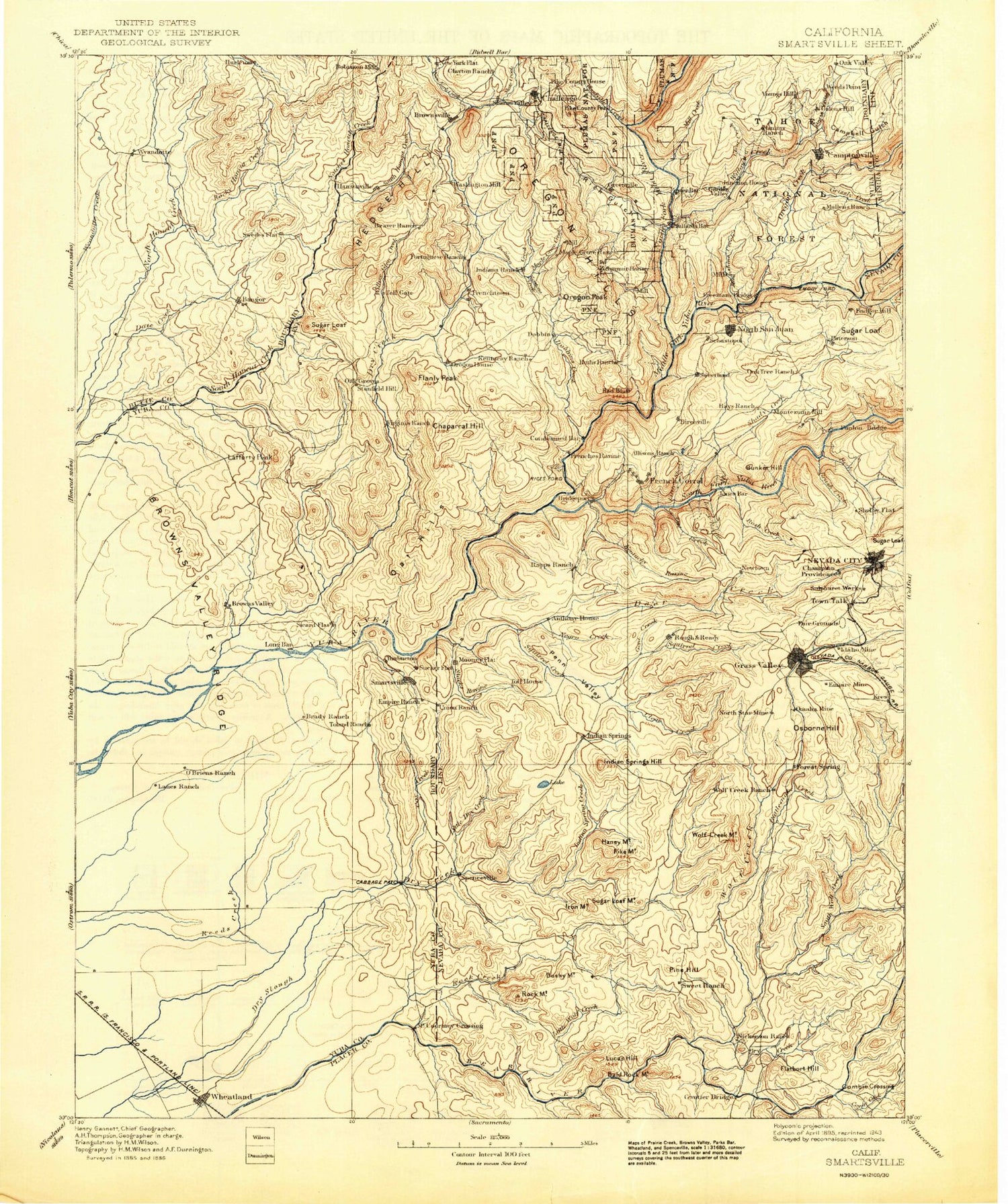
Historical USGS topographic map of Smartsville in the state of California. Scale: 1:125000. Print size: 17" x 24"
This map was published in 1895 and is in the following counties: Butte, Nevada, Placer, Sierra, Yuba.
The map contains contour lines, roads, rivers, towns, streams, and lakes. Printed on high-quality waterproof paper with UV fade-resistant inks.
Contains the following named places: Albion Ravine, Alderman Creek, Allenwood Hill, Allison Ranch Ditch, Alta Hill Reservoir, Auburn Rancheria, Austin Flat, Austin Ravine, Bald Hill Ditch, Bald Rock Mountain, Bangor, Bangor Ditch, Banner Grange, Banner Mountain Mine, Banner Reservoir, Best Slough, Big Ravine, Black Bear Mine, Blue Lead Mine, Blue Point Mine, Boardman Ranch, Bonanza Ranch, Brooks Creek, Browns Valley Ridge, Buck Mountain, Buzzard Peak, Camp Far West Historic Site, Camp Far West Ditch, Camp Far West Ranch, Camp Far West Reservoir, Carmichael Ranch, Cedar Ravine, Chaparral Hill, China Flat, Clear Creek, Cleveland Hill, Cole Ditch, Cole Hill, Combie Ophir Canal, Lake Combie, Cory Ditch, Cottage Hill, Cox Creek, Coyote Creek, Cranston Ranch, Cunningham Ditch, Daguerre Point Dam, Daguerre Point, Dairy Farm Mine, Daugherty Creek, Daugherty Hill, Deadmans Flat, Deer Creek, Dempsey Creek, Dew Drop, Donnebroug Mine, Durst Ranch, Dutch Ravine, Egbert Hill, Empire Mine, Empire Ranch, Erle Siding, Farm Ditch, Fattebort Hill, Fenton Ravine, Fine Gold Gulch, Flanly Peak, Forbes Ranch, Forest Springs Lateral, French Ravine, French Ravine, French Ravine, Fruitland Union School, Garden Bar, Gracie Mine, Granite Point, Grass Valley Ditch, Grass Valley Reservoir, Grub Creek, Hackett Creek, Haney Mountain, Hawk Ravine, Herring Reservoir, High Prairie, Hill Crest, Hog Hill, Holman Hill, Rocky Honcut Creek, Horseshoe Flat, Horton Ridge, Idaho-Maryland Ditch, Idaho-Maryland Mine, Idaho-Maryland Reservoir, Indian Springs, Indian Springs Creek, Injun Creek, Irish Ravine, Iron Mountain, Joe Miller Ravine, Katskill Hill, Kentucky Ridge, Kentucky Ridge Mine, Keystone Ranch, Knight Monument, Kyler Ditch, La Mar Flat, Lafayette Ditch, Lafferty Peak, Last Chance Mine, Lee Hill, Little Dry Creek, Little Dry Creek, Little Wolf Creek, Little Wolf Creek, Los Verjeles Dam, Loma Rica Siphon, Lone Tree, Long Bar, Long Hollow, Long Ravine, Long Ravine, Lower Ditch, Lower Rough and Ready Ditch, Lucas Hill, Magnolia Creek, Mahle Ditch, McCartie Hill, McCarty Flat, McGinn Creek, McGinn Hill, Meyer Ravine, Mistletoe Mine, Morgan Ravine, Negro Bar Creek, Nelson Ravine, New Brunswick Mine, New Hope Mine, Niagara Mine, North Star Central Shaft, North Star Mine, Old Allison Ranch Mine, Old Brunswick Mine, Olive Hill Ditch, Oregon House, Osceola Ravine, Ousley Ditch, Owens Ravine, Pal O Mine Ranch, Paynes Peak, Penn Valley, Pennsylvania Mine, Pet Hill Ditch, Phoenix Mine, Pilot Peak, Pine Hill, Pine Hill, Pine Hill Mine, Pleasant Valley, Pourier Creek, Prairie Creek, Rab Ravine, Ragsdale Creek, Randolph Flat, Rattlesnake Creek, Rattlesnake Point, Ray Hill, Red Hill, Redinger Ditch, Rex Ditch, Rex Reservoir, Rhode Island Ravine, Riffle Box Ditch, Riffle Box Ravine, Rock Creek, Rock Mountain, Rose Bar, Rose Hill, Rough and Ready Reservoir, Salt Creek, Salt Flat, Sand Hills, Sanford Creek, Scadden Flat, Scotia Mine, Sicard Flat Ditch, Sid Smith Ranch, Slacks Ravine, Slate Creek, Slide Ravine, Smethurst Mine, Smith Bar Ditch, American Ranch Hill, B Canal, Blue Ravine, China Ditch, Clear Creek Lateral, Eden Valley, Harry L. Englebright Lake, Johnson Rancho, Pennsylvania Mine, Rattlesnake Ditch, Smith-Gordon Ditch, South Fork Wolf Creek, South Star Mine, Spenceville, Spring Hill Mine, Spring Ravine, Squirrel Creek, Stanfield Hill, State Foresty Guard Station, Stockdale Ranch, Stockton Hill Ditch, Stockton Hill Mine, Stone Ditch, Stone House, Sugar Loaf Mountain, Sunset View Reservoir, Swain Hill, Swain Ravine, Sweet Vengeance Mine, Tarr Ditch, Tennessee Creek, The Narrows, The Punchbowl, Thermalands, Timbuctoo Bend, Town Talk, Trailer Hill, Trainer Hills, Tunnel Ditch, Union Hill Ditch, Union Reservoir, Upper Rocky Honcut Creek, Upper Rough and Ready Ditch, Ure Mountain, Van Giesen Dam


