MyTopo
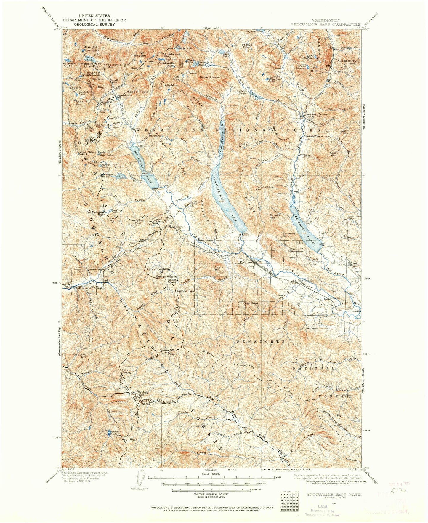
Historic 1901 Snoqualmie Pass Washington 30'x30' Topo Map
Couldn't load pickup availability
Historical USGS topographic map of Snoqualmie Pass in the state of Washington. Scale: 1:125000. Print size: 18" x 24"
This map was published in 1901 and is in the following counties: King, Kittitas, Pierce, Yakima.
The map contains contour lines, roads, rivers, towns, streams, and lakes. Printed on high-quality waterproof paper with UV fade-resistant inks.
Contains the following named places: Abiel Lake, Abiel Peak, Alaska Lake, Alaska Mountain, Alder Creek, Alta Mountain, Alta Pass, Amabilis Mountain, Annette Lake, Annette Lake Trail, Arch Rock, Arch Rock Shelter, Avalanche Lake, Baker Lake, Bald Mountain, Mount Baldy, Bear Creek, Bear Creek, Bear Creek Trail, Bear Lake, Bearpaw Butte, Beaver Lake, Bell Creek, Big Boulder Creek, Big Creek, Big Creek Trail, Blazed Ridge, Blowout Creek, Blowout Mountain, Box Canyon Creek, Box Canyon Lake, Box Ridge, Branch Creek, Bryant Peak, Bullfrog Pond, Burnboot Creek, Butte Creek, Cabin Creek, Cabin Creek, Cabin Mountain, Camp Creek, Camp Urich, Cascade Crest Trail, Mount Catherine, Cave Ridge, Cedar Creek, Cedar Notch, Chair Peak, Chair Peak Lake, Chikamin Lake, Chikamin Peak, Chikamin Ridge, China Point, Cle Elum Lake, Mount Clifty, Coal Creek, Cold Creek, Cad Lake, Cole Butte, Cole Creek, Colquhoun Peak, Commonwealth Creek, Commonwealth Campground, Cone Mountain, Cooper Lake, Cooper Pass Trail, Cooper River, Copper Pass, Corral Creek, Corral Pass, Cottonwood Lake, Cougar Valley, Cougar Valley Trail, County Creek, Crescent Lakes, Crow Creek, Crow Lake, Crystal Lake, Crystal Springs Campground, Cub Creek, Curtis Forest Camp, Dalles Ridge Trail, Dandy Pass, Davis Creek, Davis Peak, Davis Peak Lookout Trail, Delate Creek, Denny Creek, Denny Creek, Denny Lake, Derrick Lake, Diamond Lake, Disappointment Creek, Divide Lake, Domerie Creek, Domerie Flats, Domerie Peak, Domerie Peak Trail, Dry Creek, Dry Meadow, East Creek, East Fork Friday Creek, Easton, Easton Ridge, Lake Easton, Echo Lake, Edds Lake, Elbow Peak, Elsnor Mine, Escondido Lake, Escondido Trail, Falls Creek, Fawn Creek, Fishhook Flats, Fishhook Flats Trail, Fort Tilton Historical Marker, Fortune Creek, Franklin Falls, French Cabin Basin, French Cabin Creek, French Cabin Mountain, Friday Creek, Frog Lake, Frost Meadows, Frost Mountain Lookout Trail, Frozen Lake, Gale Creek, Gem Lake, George Creek, George Lake, Glacier Lake, Goat Creek, Goat Creek, Goat Mountain, Goat Peak, Goat Peak Trail, Gold Creek, Gold Creek Valley, Gold Lake, Government Meadow, Granite Creek Trail, Granite Mountain, Gravel Lake, Greek Creek, Green Pass, Green River Watershed, Greenwater Lakes, Greenwater Trail, Guye Peak, Hardwood Creek, Hawkins Mountain, Hemlock Pass, Hereford Meadow, Hex Creek, Hex Mountain, Hibox Lake, Hicks Butte, Hicks Butte Trail, Hidden Lake, Hour Creek, Howson Creek, Huckleberry Forest Camp, Huckleberry Mountain, Huckleberry Mountain, Hudson Creek, Humpback Creek, Humpback Mountain, Hyak, Hyak Creek, Hyak Lake, Mount Hyak, Ice Lake, Intake Creek, Island Mountain, Jim Creek, Joe Lake, Jolly Mountain, Jolly Mountain Lookout Trail, Jungle Creek, Jungle Creek Campsite, Kachess Dam, Kachess Guard Station, Kachess Lake, Kachess Ridge, Kachess Ridge Trail, Kachess River, Kaleetan Lake, Kaleetan Peak, Kaner Flat, Kaner Flat Trail, Keechelus Dam, Keechelus Lake, Keechelus Ridge, Keekwulee Falls, Kelly Butte, Kelly Butte Trail, Kendall Peak, Kendall Peak Lakes, Kid Creek, Knox Creek, Lake Easton State Park, Lake Michael Trail, Lakedale, Lake Laura, Lemah Creek, Lester, Lester Creek, Lila Lake, Lake Lillian, Lily Pond Lake, Little Boulder Creek, Little Creek, Little Creek Basin Trail, Little Joe Lake, Little Kachess Lake, Little Salmon la Sac Creek, Lizard Lake, Lodge Creek, Lodge Lake, Log Creek, Log Creek Trail, Longmire Meadow, Lookout Creek, Lookout Mountain, Lost Creek, Lost Lake, Lost Lake, Lost Lake Trail, Lost Meadow, Louisiana Saddle, Low Mountain, Lower Tuscohatchie Lake, Lower Wildcat Lake, Lundin Peak, Maggie Creek, Maggie Creek Trail