MyTopo
Historic 1892 Springville Alabama 30'x30' Topo Map
Couldn't load pickup availability
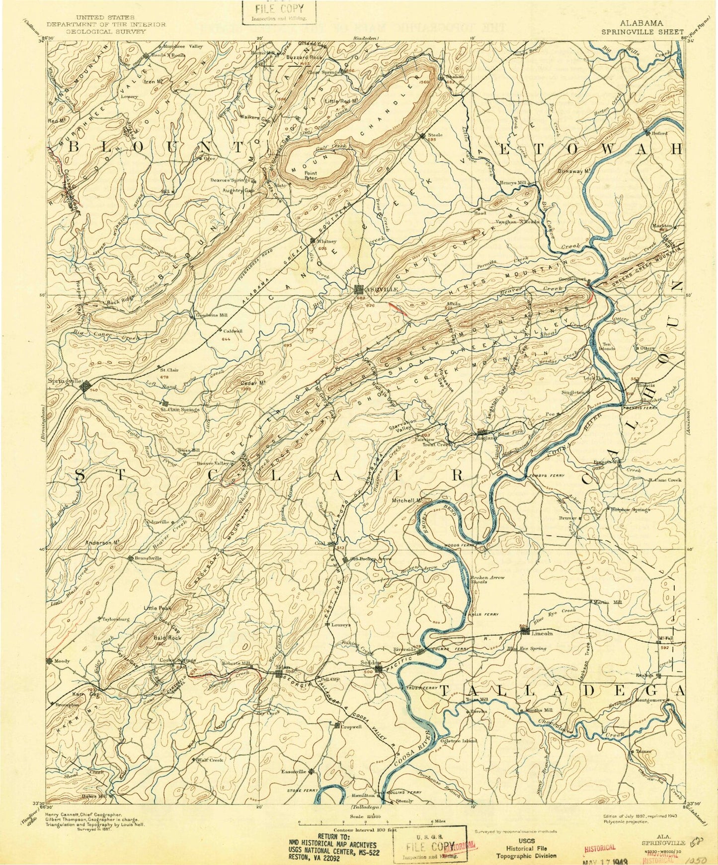
Historical USGS topographic map of Springville in the state of Alabama. Scale: 1:125000. Print size: 17" x 24"
This map was published in 1892 and is in the following counties: Blount, Calhoun, Etowah, Shelby, St. Clair, Talladega.
The map contains contour lines, roads, rivers, towns, streams, and lakes. Printed on high-quality waterproof paper with UV fade-resistant inks.
Contains the following named places: Lincoln, Bald Hill, Blue Eye Creek, Box Creek, Brasher Creek, Broken Arrow Shoals, Bruner Creek, Bunch Creek, Buzzard Rock, Byrd Creek, Champion Creek, Clubview Heights, Difficulty Branch, Dodds Gap, Drake Island, Dry Creek, Dunaway Mountain, Eastwood, Fall Branch, Francis Mill, Gallant, Gilland Gap, Greens Creek, Greens Creek Mountain, Griffitt Bend, Harris Creek, Hensley Mountain, Highland Lake, Hillhouse Lake, Holly Springs, Hoods Creek, Hoods Crossroads, Horton Creek, Ingram Lake, Jackson Shoals, Jourden Creek, Lyles Lake, Markton, McClendon Gap, Morgans Crossroads, Ohatchee, Ohatchee Creek, Old Harmony, Ottery Creek, Raccoon Mountain, Red Mountain, Rolling Fields, Sand Creek, Southside, Spout Spring Gap, Taits Gap, The Narrows, Whited Lake, Williams, Woodard Creek, Birmingham Saw Works Lake Dam, Watkins Dam, Watkins Lake, Rod and Reel Dam, Rod and Reel Lake, Cone Reservoir, Blue Eye Creek Watershed Dam Number 2, Carrols Lake, Jones Blue Eye Lake, Blue Eye Creek Watershed Dam Number 1, Brooks Dam, Steed Dam, Steeds Lake, Yarbrough Dam, Yarbroughs Lake, McGouirk Dam, McGouirk Lake, Lyles Dam, Cooper Dam, Coopers Lake, Highland Lake Dam, Sugarland Lake, Sugarland Lake Dam, McKay Lake, McKay Lake Dam, Will Engle Lake, Will Engle Dam, Wadsworth Lake, Wadsworth Lake Dam, Cardwell Dam, Cardwell Lake, Kimball Lake, Kimball Lake Dam, Perman Dam, Permans Lake, Reeves Lake Dam, Reeves Lake, Doctor Pattons Lower Lake Dam, Doctor Pattons Lower Lake, Robbins Lake, Robbins Lake Dam, Wessons Lake, Wesson Dam, Littles Dam, Littles Lake, Whited Lake Dam, McPherson Lake, McPherson Dam, Etowah Conservation Dam, Vandegrift Pond Dam, Vandegrift Pond, Appalachian, Bennett Mine, Harvey Mine, Iron Mountain, Mountain View, Murphree, Robin Coal Mines, Straight Mountain, Sugarland Lake Resort, Taits Gap Drift Mine, Showboat Camp, Agricola Lake, Airport Industrial Park, Attalla City Park, Attalla Speedway, Banks Park, Chateau Charolais Lake, Gadsden Country Club, Gadsden Mall Shopping Center, Genie Drew Village Shopping Center, Rainbow City Park, Rainbow Plaza Shopping Center, Riddles Bend, Siberton Park, Phillips Gap, Windsong Island, Alabama Short Track Raceway, Alligator Branch, Binghamtown, Blue Eye, Blue Spring Branch, Brooks Lake, Bruner Creek, Camelot Plateau, Cape Choccolocco, Capri Islands, Catfish Lake, Choccolocco Estates, Clear Springs, Clear Springs Marina, Colony, Crawfish Pond, Davis Acres, Echo Hills, Embry Bend, England Isle, Eureka Shores, Fishermans Wharf Marina, Franksdale Farm, Howells Cove, Pleasant Grove, Plum Springs, Plum Springs Branch, Providence, Ragland Mountain, River Terrace Estates, Schoolhouse Mountain, Shelton Lake Shores, Sherwood Shores, Talladega Industrial Park, Wendy Wood, Lake Whitwood, Yatesville, Bethlehem, Cedar Bend, Garigus Gap, Green Valley, Lester, Millers Creek, Moodys Chapel, Pilgrims Rest, Shiloh, Siberton, Whortons Creek, Point Jones, Kirkseys Bend, Lick Branch, Mitchellville, Mount Olive, Poes Bend, Ragan Chapel, Stillhouse Branch, Big Wills Creek, Black Creek, Leota Shoals, Hurricane Creek, Ogletree Island, Old Eastaboga, Oneonta, Rainbow City, Ramsey, Rook Creek, Boiling Springs, Champion, Chepultepec, Dry Valley, Francis, Lawley, Mattawana, Ottery, Riverside, Smiths Mill, Stemley, Sulphur Springs, Taits Gap, Turner, Acker Creek, Eastaboga, Martins Mill, Embry Crossroads, The Brick Store, Cheaha Creek, Choccolocco Creek, Eastaboga Creek, Kelly Creek, Poorhouse Branch, Stoney Branch, Buck Ridge, International Speedway, Acmar, Anderson Mountain, Ashville, Avondale Village, Awtreys Gap, Backbone Mountain, Bald Rock Mountain, Baptist Camp, Barker Mountain, Battle Gap, Beason Cove