MyTopo
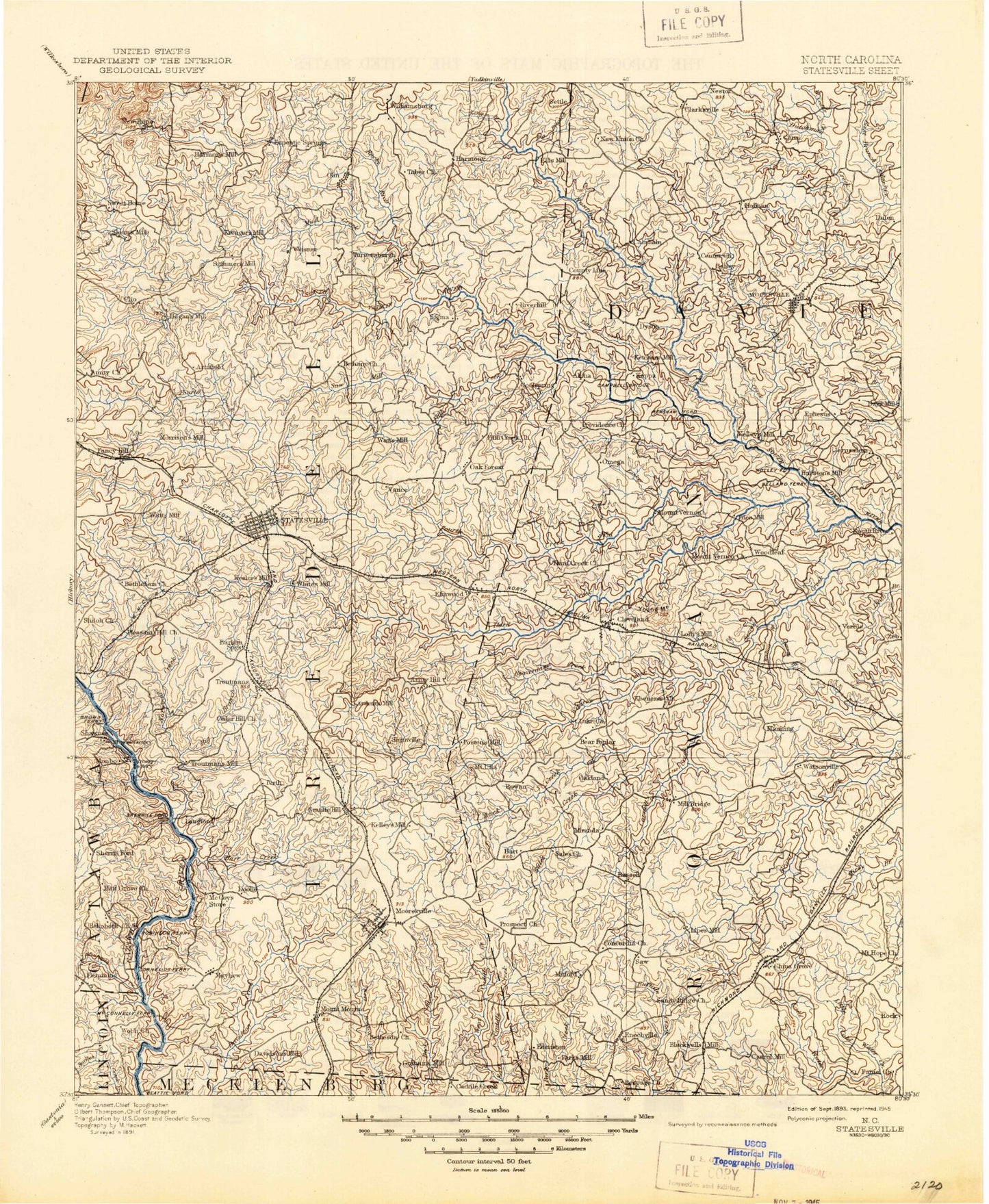
Historic 1893 Statesville North Carolina 30'x30' Topo Map
Couldn't load pickup availability
Historical USGS topographic map of Statesville in the state of North Carolina. Scale: 1:125000. Print size: 18" x 24"
This map was published in 1893 and is in the following counties: Cabarrus, Catawba, Davie, Iredell, Lincoln, Mecklenburg, Rowan.
The map contains contour lines, roads, rivers, towns, streams, and lakes. Printed on high-quality waterproof paper with UV fade-resistant inks.
Contains the following named places: Amity Hill, Balls Creek, Bass Creek, Baxter Creek, Bear Creek, Beaver Creek, Beaver Creek, Beaverdam Branch, Beaverdam Creek, Beaverdam Creek, Beaverdam Creek, Becks Spring Branch, Bell Branch, Bettie Branch, Blue Branch, Brady Branch, Bryant Branch, Buck Branch, Byers Creek, Camel Branch, Cedar Creek, Central, Cooleemee, Cornelius Creek, Corriher Field, Corriher Heights, Lake Corriher, Cub Creek, Davidson Creek, Davie Academy Corners, Doolie, Draft Branch, Dripoff Branch, Duck Creek, Duke Powder State Park, Dutchman Creek, Dye Creek, East Fork, East Monbo, Elmwood, Enochville, Ephesus, Five Forks, Flat Rock Branch, Fourth Creek, Frost Mill Creek, Gambles Creek, Gold Mine Island, Greasy Creek, Greasy Creek, Gregory Creek, Hager Creek, Harmony, Hicks Creek, Hobbs Creek, Hobbs Creek, Holdsclaw Creek, Hunting Creek, I-L Creek, Ijames Crossroads, Jack Creek, Kannapolis Lake, Kerr Branch, Kerr Creek, Kinder Creek, Lakewood Park, Leonard Creek, Little Bear Creek, Little Creek, Little Creek, Little Creek, Little Creek, Little Rocky Creek, Long Branch, Maine, Mayhew, Mazeppa, McCrary Creek, McHargue Mountain, Mill Branch, Mill Bridge, Mooresville, Morrison Creek, Morrison Spring Branch, Mount Ulla, Mountain Creek, Lake Myers, Needmore, Nelson Creek, Noland Creek, Lake Norman, North Kannapolis, Norwood Creek, Olin, Olin Creek, Outz Creek, Patterson Creek, Powder Spring Branch, Prospect Branch, Reeder Creek, Reeds Creek, Rich Park, Rocky Branch, Rocky Creek, Rocky Creek, Rowan Correction Center, Setman Branch, Shepherds, Shinns Creek, Shinnville, Sills Creek, Skyview Lake, Sloans Creek, Smith Grove, Snow Creek, South Fork Withrow Creek, Statesville, Statesville Country Club, Stumpy Creek, Sugar Creek, Terrapin Creek, Terrell, Third Creek, Troutman, Tuckers Creek, Walnut Branch, Weathers Creek, Westmoreland Creek, Williamsburg, Withrow Creek, Woodleaf, Work Creek, Lake Wright, Edwards Lake, Edwards Lake Dam, Lake Kannapolis Dam, W M Wilkinson Dam, Lake Corrier Dam, Regency Lake, Auto Storage Dam Number One, Auto Storage Dam Number Two, Auto Storage Lake Number Two, Landis Water Reservoir Lake, Landis Water Reservoir Dam, Duke Power Park Dam, Duke Power Park Lake, Rowan County Wildlife Lake, Rowan County Wildlife Lake Dam, Fiber Lake, Fiber Lake Dam, Hall Lake Dam, Hall Lake, J C Neely Dam, Noname, Noname, J C Murdock Dam, Noname, Presbyterian Orphanage Dam, Barium Spring Orphanage Dam, Kenneth Raymer Lake, Kenneth Raymer Lake Dam, Noname, William L Walker Dam, Noname, T S Stewart Dam, Brookdale Lake Dam, Brookdale Lake, Noname, J W Lackey Dam, Woods Drive Lake, Woods Drive Dam, Cooleemee Dam, Burlington Mills Lake, Hawthorne Lake, Hawthorne Dam Lower, Hoffners Lake, Hoffners Lake Dam, Hawthorne Dam Upper, Wilson Brothers Dam Number Two, Wilson Brothers Lake Number Two, Wilson Brothers Dam Number One, Wilson Brothers Lake Number One, Hatfield Association Lake, Hatfield Association Lake Dam, Statesville Flour Mill Dam, Scotch-Irish Plantation Lake Dam, Scotch-Irish Plantation Lake, Daniels Lake Dam, Daniels Lake, Crawford Dam, Martin Dam, Windy Hill Acres Lake Dam, Windy Hills Acres Lake, Martins Lake Dam, Martins Lake, Allison Lake, Allison Lake Dam, Mocksville Lake Dam, Mocksville Lake, Skyview Lake Lower Dam, Skyview Lake Lower, Skyview Lake Upper, Skyview Lake Dam Upper, Wilson Godfrey Dam, Dutchman Creek W/S Number Ten, Dutchman Creek W/S Structure Number Six Dam, Dutchman Creek W/S Number Six, Back Creek, Ostwalt, Anderson Park, Camp Alwood, Cloverdale, Colliers Lake Park, Forest Heights Shopping Center, Gateway Shopping Center, Grace Park, I-40 Park, Long Camp, McCrary Access Area, Monticello, Mooresville Plaza, Newtowne Mall, Oakland Heights, Pinnacle Access Area, Signal Hill Shopping Center, Southland Shopping Center, Statesville West, Town and Country Shopping Center, V Point, Valley Stream, Vance, Watts Park, West Park Shopping Center, West Statesville, Westgate Shopping Center, Westwood