MyTopo
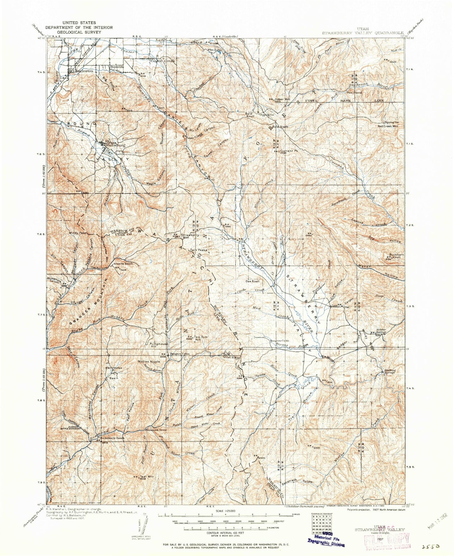
Historic 1907 Strawberry Valley Utah 30'x30' Topo Map
Couldn't load pickup availability
Historical USGS topographic map of Strawberry Valley in the state of Utah. Scale: 1:125000. Print size: 17" x 24"
This map was published in 1907 and is in the following counties: Utah, Wasatch.
The map contains contour lines, roads, rivers, towns, streams, and lakes. Printed on high-quality waterproof paper with UV fade-resistant inks.
Contains the following named places: Bear Hollow, Bellows Hollow, Big Hollow, Buck Basin, Buck Hollow Ridge, Burnt Hollow, Camp Hobble Creek, Cedar Canyon, Charleston, Charleston, Currant Creek Peak, Days Canyon, Dip Vat Hollow, Granger Canyon, Granger Mountain, Hanks Canyon, Harvey Meadow, Heber Mountain, Hobble Creek Guard Station, Kirkman Hollow, Left Fork Days Canyon, Lower Charleston Canal, North Ditch, Packard Creek, Red Pine Knoll, Right Fork Days Canyon, Roundy Basin, Trail Hollow, Wanrhodes Basin, Wide Hollow, Midview Dam, Center Creek Number Five Reservoir, Center Creek Number Five Dam, Dee Mills Reservoir, Dee Mills Dam, Thorn Hollow, Humbug Canal, Balsam Campground, Cherry Picnic Area, Dry Canyon Picnic Area, Kolob Campground, Lone Fir Picnic Area, Badger Hollow, Bald Knoll, Baldy Mountain, Balsam Bench, Balsam Creek, Bartholomew Canyon, Bear Canyon Pass, Bear Hole, Bear Hole Hollow, Becky Basin, Berryport Canyon, Big Glade, Big Pole Canyon, Billies Mountain, Bills Basin, Billy Haws Canyon, Bjorkman Hollow, Boomer Canyon, Boren Ditch, Brimhall Canyon, Broad Hollow, Brumley Creek, Bryants Fork, Bryants Fork Guard Station, Buck Knoll, Buckhorn Knoll, Buffalo Canyon, Cabin Hollow, Camp Hollow, Camp Strawberry, Campbell Hollow, Center Canyon, Center Canyon, Center Creek, Center Creek, Chase Creek, Chicken Creek, Chicken Hollow, Chipman Creek, Clark Hollow, Clarks Camp, Clegg Canyon, Clyde Creek, Co-op Creek, Coal Canyon, Coal Mine Campground, Coal Mine Hollow, Coleman Basin, Corral Canyon, Corral Hollow, Cottonwood Canyon, Cow Camp, Cow Hollow, Coyote Ridge, Crooked Creek, Crooked Creek, Cummings Canyon, Cummings Flat, Currant Creek Feeder Canal, Currant Creek Guard Station, Daniels Canyon, Daniels Creek, Daniels Pass, Death Hollow, Deer Creek Reservoir, Diamond Battle Historical Monument, Diamond Campground, Diamond Fork Guard Station, Dip Vat Creek, Dock Flat, Dockweed Flat, Doe Knoll, Dry Canyon, Dry Canyon, Dry Canyon, Duchesne Ridge, East Fork Mill Hollow, East Fork Three Forks, East Portal, Farmer Slope, Fifth Water Creek, Fifth Water Ridge, First Water Cabin, First Water Creek, First Water Ridge, Foreman Hollow, Fourth Water Creek, Fourth Water Ridge, French Hollow, Fullmer Hollow, Glen Cabin Creek, Green Knoll, Halls Fork, Harris Reservoir, Hawthorn Campground, Heber Valley, Highline Canal, Hildas Basin Creek, Hobble Creek, Hogsback Exclosure, Hogsback Ridge, Horse Creek, Hub Guard Station, Indian Creek, Island Mountain, Jimmies Basin, Jimmies Point, Jocks Canyon, Johns Glen, Jones Basin, Jones Cabin Creek, Jones Hollow, Jux Canyon, Lake Fork, Layout Canyon, Left Fork Currant Creek, Left Fork Little Hobble Creek, Left Fork Timber Canyon, Little Baldy Mountain, Little Co-op Creek, Little Diamond Creek, Little Hobble Creek, Little Pole Canyon, Little Valley, Little West Fork, Lodge Pole Campground, Low Pass, Low Pass Creek, Main Creek, Maple Canyon, Maple Creek, McGuire Hollow, Mill A Hollow, Mill B Canyon, Mill B Flat, Mill Hollow Guard Station, Mill Hollow Reservoir, Miller Ridge, Mineral Spring Campground, Mollies Nipple, Monks Hollow, Mud Creek, Murdock Hollow, Neeley Basin, North Fork Three Forks, Oak Spring Canyon, Owens Canyon, Packard Canyon, Palmyra Campground, Parker Canyon, Partridge Ridge, Pass Creek, Pass Creek, Patrick Place, Penrod Creek, Pete Canyon, Pine Hollow, Point of Pines Canyon, Poison Ridge, Pole Heaven, Pump Ridge, Pumphouse Hill, Racetrack Creek, Racetrack Hollow, Rattlesnake Mountain, Rays Valley, Red Creek Mountain, Red Hollow, Red Ledge, Red Ledge, Red Ledge Hollow, Red Mountain, Right Fork Currant Creek, Right Fork Dry Canyon, Mill Hollow, Right Fork Little Hobble Creek, Right Fork Timber Canyon, Road Hollow, Road Hollow, Rock Slide Canyon, Round Valley, Row Bench, Row Hollow, Sage Creek, Sagebrush and Spring Creek Canal, Sams Canyon, Sams Canyon, Sandstone Basin, Sawmill Hollow, Schoolhouse Creek, Scotty Basin, Second Set, Second Water Creek, Second Water Ridge