MyTopo
Historic 1901 Sumpter Oregon 30'x30' Topo Map
Couldn't load pickup availability
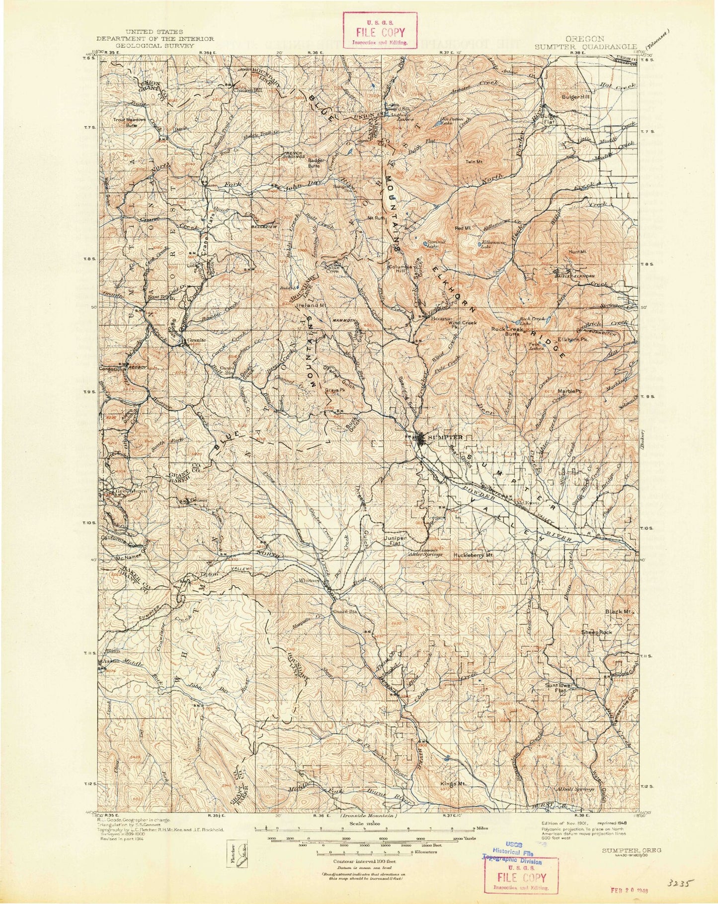
Historical USGS topographic map of Sumpter in the state of Oregon. Scale: 1:125000. Print size: 17" x 24"
This map was published in 1901 and is in the following counties: Baker, Grant, Union.
The map contains contour lines, roads, rivers, towns, streams, and lakes. Printed on high-quality waterproof paper with UV fade-resistant inks.
Contains the following named places: Long Meadow, Antone Burn, Marble Creek Recreation Site, Imperial Eagle Mine, Alder Creek, Amazon Mine, Analulu Mine, Angell Basin, Angell Peak, Antelope Peak, Anthony Lake, Anthony Lakes, Antone Creek, Argonaut Mine, Baboon Creek, Badsky Pond, Bald Mountain Mine, Baldy Lake, Beagle Creek, Bear Butte, Bear Canyon, Bear Creek, Bear Meadow, Beaverdam Buttes, Beaverdam Creek, Beaverdam Pond, Belle of Baker Mine, Birch Creek, Black Lake, Black Mountain, Blume Zilkey Ditch, Bobier Meadow, Bobier Slide, Borden Gulch, Boundary Creek, Boundary Creek Forest Service Station, Bridge Creek, Brooklyn Mine, Brown Loennig Ditch, Buck Gulch Mine, Bucket Lake, Buckeye Mine, Buckhorn Mine, Bulger Ditch, Bulger Flat, Bulger Hill, Bunker Hill Mine, Cable Cove, California Mine, Camp Creek, Camp Lee, Cap Martin Mine, Channel Creek, China Creek Corral Pond, Chloride Mine, Chloride Ridge, Clapp Meadow, Clear Creek, Clear Creek, Columbia Mine, Corey Gulch, Cougar Basin, Cougar Pond, Cracker Camp, Crevice Creek, Crown Point, Crown Point Mine, Cunningham Cove, Cunningham Saddle, Dean Creek, Deep Creek, Deer Creek, Deer Creek Recreation Site, Downie Lake, Dutch Flat, Dutch Flat Creek, Dutch Flat Lake, Dutch Flat Saddle, E and E Mine, East Fork Alder Creek, East Fork Birch Creek, East Fork Boundary Creek, East Fork Miners Creek, East Fork Pole Creek, Eilertson Meadow, Elk Heaven Mine, Elkhorn Crest Trail, Elkhorn Peak, Elkhorn Ridge, Erin Creek, Erin Meadow, Esmeralda Mine, Excuse Mine, Fannie Meadows, Farmers Ditch, First Creek, Floodwater Flats, Ford Ingram Ditch, Fruit Creek, Gardner Mill Race Ditch, Gee Creek, Golconda Mine, Gold Bug-Grizzly Mine, Gold Center, Gold Center Meadow, Goodrich Lake, Gorham Gulch, Grand Central Mine, Grand Trunk Mine, Grande Ronde Lake, Grays Gulch, Grays Peak, Griffith Placer, Gunsight Mountain, Haines Pond Number Two, Haystack Meadows, Herculean Mine, Highland Mine, Highland Trail, Hoffer Lakes, Horse Creek, Horse Creek, Hudspeth Corral, Hudspeth Cow Camp, Hunt Mountain, Hutchinson Ditch, Ibex Mine, Ivy May Mine, Jimmy Creek, Jordan Creek, Kane Creek, Kelly Mine, Killamacue Creek, Killamacue Lake, King Ranch, Lake Creek, Last Chance Mine, Lawrence Creek, Lead Lode Mine, Lees Peak, Lilypad Lake, Little Antone Creek, Little Cracker Creek, Little Dean Creek, Little Marble Creek, Little Mill Creek, Little Summit Lake, Locken Meadow, Long Gulch, Lost Lake, Lost Lake Saddle, Lower Baisley-Elkhorn Mine, Lower Fisher Long Ditch, Loy Mine, Mahoney Meadows, Maidens Dream Mine, Mammoth Mine, Mansfield Ditch, Marble Creek, Marble Point, Maxwell Ditch, Maxwell Mine, Mayflower Meadow, McCully Recreation Site, McHenry Flat, Meadow Lake, Middle Camp Baisley-Elkhorn Mine, Mile High Mine, Miller Ditch, Miners Creek, Molly Gibson Mine, Monumental Mine, Mormon Boy Mine, Mount Ruth Cove, Mount Ireland, Mountain Belle Mine, Mountain View Mine, Mud Lake, Mud Springs Gulch, Nelson Ditch, Nip and Tuck Pass, North Fork North Powder River, North Fork Pine Creek, North Fork Rock Creek, North Pole Mine, O'Farrel Gulch, Onion Gulch, Ophir Mine, Oregon Chief Mine, Parker Creek, Penstock Olsen Ditch, Pole Creek, Pole Creek Camp, Pole Creek Ridge, Powers Ditch, Quartz Gulch, Rattlesnake Gulch, Red Chief Mine, Red Mountain, Red Mountain Lake, Rob Roy Mine, Rock Creek Butte, Rock Creek Lake, Rock Creek Lake Trail, Rock Creek Powerplant, Rock Creek Reservoir, Rockne Gulch, Rocky Ford Campground, Mount Ruth, Sardine Gulch, Sheep Creek, Sheep Rock, Sherman Creek, Silver Creek, Silver Creek Camp, Silver Dick Mine, Slim Creek, Smith Creek, Snell Hollow, Snowslide Canyon, South Pole Mine, South Prong Pine Creek, Spaulding Gulch, Spaulding Ridge, Stovepipe Gulch, Summit Lake, Sumpter Reservoir, Sunflower Flat Pond, Sunnybrook Mine, Swamp Creek, Tencent Placer Mine, The Lakes Lookout, Twin Lakes, Twin Lakes Trail, Twin Mountain, Twin Mountain Creek