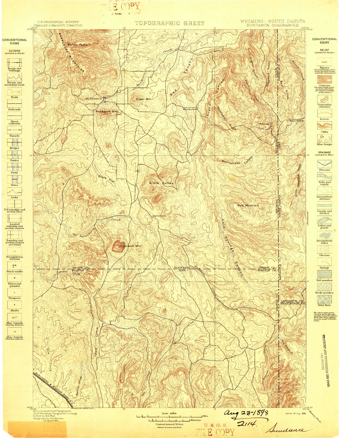
MyTopo
Historic 1898 Sundance Wyoming 30'x30' Topo Map
Couldn't load pickup availability
Historical USGS topographic map of Sundance in the state of Wyoming. Scale: 1:125000. Print size: 16" x 24"
This map was published in 1898 and is in the following counties: Crook, Lawrence, Pennington, Weston.
The map contains contour lines, roads, rivers, towns, streams, and lakes. Printed on high-quality waterproof paper with UV fade-resistant inks.
Contains the following named places: Bear Canyon, Beaver Creek, Cold Springs Creek, East Fork Boundary Gulch, Grand Canyon, Mallory Gulch, Negro Hill, Riflepit Canyon, Wagon Canyon, Wet Parmlee Canyon, Dry Parmlee Canyon, Adams Canyon, Barnett Draw, Berry Canyon, Bertha Canyon, Black Buttes, Black Flats, Black Haw Gulch, Boardinghouse Creek, Bock Hill, Bush Ranch, Calvin Creek, Clay Spur, Cranberry Springs Gulch, Delaney Canyon, Dry Draw, Duling Hill, Elkhorn Divide, Fish Canyon, Fish Mountain, Hegge Ranch, Homestake Lookout, Hooker Peak, Horse Canyon, Iron Mountain, Johnson Draw, Jones Ranch, Jordan Draw, Kaiser Divide, Koksh Ranch, Lime Buttes, Lincoln Ranch, Little Turner Creek, Lost Canyon, Love Canyon, Manhattan Gulch, Melquist Gulch, Miller Ranch, O'Haver Hill, O'Haver Peak, Pfeiffer Hill, Pine Gulch, Piney Ridge, Buck Hollow, Riflepit Divide, Seely Ranch, Shale Hill, Spring Branch, Stanton Draw, Sunquist Draw, Thompson Ranch, Walcott Draw, Horton, Buckhorn, Skull Creek, Adams Gulch, Bald Mountain, Bear Den Canyon, Bear Lake, Bear Lodge Mountains, Benton Creek, Bock Mine, Boundary Gulch, Buckley Canyon, Bull Hill, Bull Hill, Calvary Sacket Draw, Canyon Springs Prairie, Carson Draw, Cement Ridge, Chassell Creek, Cleo Creek, Coal Mine Hill, Cole Canyon, Corral Creek, Cummins Gulch, Cundy Creek, Deer Creek, Dry Creek, Dry Draw, Dugout Gulch, Duling Canyon, East Fork Boundary Gulch, East Fork Dugout Gulch, East Iron Creek, G Reynolds Ranch, Green Hill, Green Mountain, Green Mountain Draw, H Reynolds Ranch, Horsethief Canyon, Hospital Gulch, Houston Ridge, Hoyer Creek, Idol Gulch, Inyan Kara Mountain, Jacobson Draw, Jim Wayne Canyon, Kirley Gulch, Krusee Canyon, Kunath Ranch, Mount Lewisa, Lincoln Gulch, Lost Houston Creek, Lytle Hill, Mallo Camp, Mallory Gulch, Medicine Flat, Medicine Flat Creek, Medicine Lake, Middle Fork Boundary Gulch, Mineral Hill, North Fork Sundance Creek, North Spring Creek, Northwestern Table, Ogden Creek, Parmlee Canyon, Pat Draw, Paxton Creek, Plato Gulch, Plato Ranch, Poison Creek, Pole Cabin Gulch, Ragged Top, Ranch A, Rattlesnake Canyon, Red Canyon Creek, Red Creek, Reuter Canyon, Reuter Canyon Campground, Reuter Draw, Richardson Creek, Riflepit Canyon, Rocky Ford Creek, Roena Gulch, Rupe Hill, Sand Creek Crossing, Schelldorf Draw, Schoolhouse Gulch, Sheldon Creek, Silver Creek, Smith Draw, Smith Ridge, Soldier Creek, South Fork Ogden Creek, Spottedtail Gulch, Spring Creek, Spring Creek, Spring Creek, Spring Creek, Spring Draw, Star Butte, Straight Lake, Strawberry Mountain, Sugarloaf, Sundance, Sundance Mountain, Surprise Gulch, Sweetwater Mountain, Tent Canyon, Thompson Gulch, Mount Tom, Warner Springs Creek, Warren Peaks, Washington Park, Welcome, West Fork Benton Creek, West Fork Boundary Gulch, West Fork Dugout Gulch, West Fork Skull Creek, Williams Divide, Williams Gulch, Willow Springs, Sundance District Ranger Station, Vista West Trailer Park, Eureka Number Mine, Ranch A National Fish Genetics Laboratory, Bearing Tree, Douglas Place, Sweet Ranch, Kellog Reservoir, Arledge Ranch, Cedar Knoll, Big Delaney Dam, Big Delaney Reservoir, V E Lissolo Dam, Perino Dam, Perino Reservoir, Edwards Number 3 Dam, Edwards Number 3 Reservoir, Clark Dam, Clark Reservoir, Rocky Ford Dam, Rocky Ford Reservoir, Russell Storage Dam, Russell Storage Reservoir, Cedar Dam, Cedar Reservoir, Paxton Dam, Paxton Reservoir, Jeff Davis Dam, Jeff Davis Reservoir, Gose Dam, Gose Reservoir, Spring Branch Development Company Dam, Spring Branch Development Company Reservoir, Dry Beaver Creek, Gypsum Buttes, Moskee, Red Butte, Williams-Surprise Divide, Summit Materials Quarry Mine, Watson Pit Mine, Albert Mann Mine, Belsher Mine, Bolton Mine, Bear Creek Mountains Mine, Inum Group Mine, Black Butte Deposit Mine, Royal Purple Number One and Number Two Mine, Bear Lodge District Mine, Bear Lodge Mining District Mine, Copper Prince Mine, Government Valley Mine, Hutchins Consolidated Gold Mining Mine, Jim Wayne Canyon Mine