MyTopo
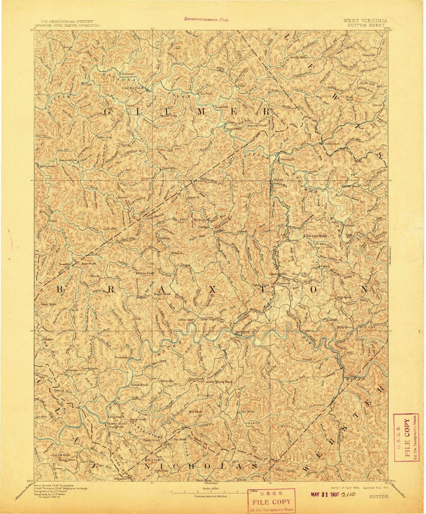
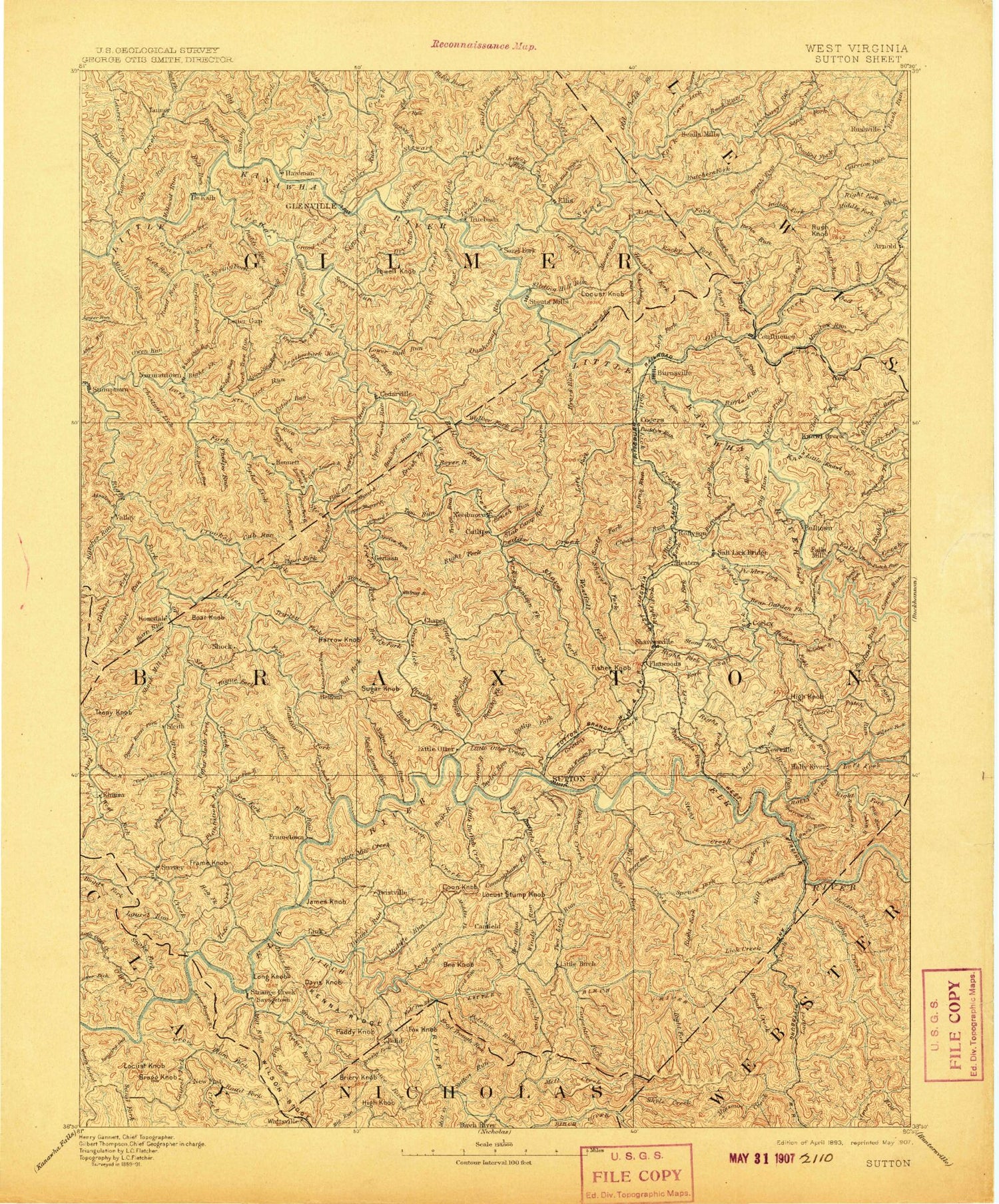
Historic 1893 Sutton West Virginia 30'x30' Topo Map
Couldn't load pickup availability
Historical USGS topographic map of Sutton in the state of West Virginia. Scale: 1:125000. Print size: 17" x 24"
This map was published in 1893 and is in the following counties: Braxton, Calhoun, Clay, Gilmer, Lewis, Nicholas, Webster.
The map contains contour lines, roads, rivers, towns, streams, and lakes. Printed on high-quality waterproof paper with UV fade-resistant inks.
Contains the following named places: Anthony Fork, Aspinall Run, Baker Hollow, Bakers Run, Bakers Run Camping Area, Barbecue Run, Barbecue Run, Barker Ridge, Barn Run, Barnett Run, Barnette Hill, Bays, Bear Run, Bear Run, Bear Run, Bear Run, Bear Run, Bee Hollow, Bee Run, Bee Run, Bee Run, Bee Run, Bee Run Campsite, Bee Run Picnic Area, Beech Fork, Belknap Hollow, Bender Run, Benny Run, Bens Run, Bens Run, Berry Fork, Berry Siding, Big Fork, Big Hollow, Big Pine Knob, Big Run, Big Run, Big Run, Big Run, Big Run, Big Run, Big Run, Big Run, Big Run, Bills Fork, Bills Fork, Bloody Run, Blowntimber Run, Blue Hole, Bluelick Run, Boar Knob, Boggs Fork, Bower Run, Brady Fork, Bragg Knob, Bragg Run, Brier Run, Brierylick Run, Brock Run, Brock Run Camping Area, Brooks Creek, Browns Run, Browns Run, Brush Camp Run, Brush Fork, Brush Run, Brush Run, Brushy Branch, Brushy Fork, Brushy Fork, Brushy Fork, Brushy Hollow, Buck Knob, Buck Ridge, Buckeye Creek, Buckeye Fork, Buena Branch, Buffalo Creek, Buffalo Creek, Buffington Run, Bug Ridge, Bull Fork, Bull Fork, Bull Run, Burns Fork, Burns Run, Butchers Fork, Butchers Run, Butchers Run, Cabin Run, Calf Run, Camp Creek, Camp Run, Canoe Run, Canoe Run, Canoe Run, Carpenter Fork, Carpenter Fork, Carpenter Fork, Carter Hollow, Cedar Creek, Cedar Creek State Park, Cedarville, Chapel, Chestnut Bottom Run, Chestnut Run, Chestnutlick Run, Chop Fork, Clapboard Run, Cloat Run, Clover Fork, Coal Run, Coalbed Run, Collins Run, Collins Run, Coolspring Run, Coon Creek, Coon Den Run, Coon Hollow, Coon Knob, Coon Run, Copen Run, Coplin Run, Corbett Run, Cove Lick, Cow Run, Cowskin Fork, Crooked Fork, Crooked Fork, Crooked Run, Crooked Run, Cub Run, Cunningham Fork, Curry Ridge, Cutlips Fork, Davis Run, Diatter Run, Dry Fork, Dry Fork, Dry Fork, Dry Fork, Dry Run, Dry Run, Duck, Duck Creek, Duck Creek, Dumpling Run, Duskcamp Run, Eli Taylor Knob, Eliza Run, Elk River Wildlife Management Area, Elliott Run, Ellis Creek, England Run, Erbacon, Exchange, Fall Run, Falls Run, Feedtrough Run, Fisher Run, Fishpot Run, Flat Run, Flat Run, Flatwoods, Flatwoods Run, Flesher Run, Ford Run, Fork Ellis Creek, Fox Knob, Frame Fork, Frame Knob, Frame Run, Frame Run, Frametown, Gassaway, Gate Fork, Givens Fork, Glenville, Gluck Run, Goosepen Run, Grandcamp Run, Granddaddy Run, Granny Creek, Grass Run, Grass Run, Grasslick Run, Grasslick Run, Grassy Run, Gravel Fork, Groves Creek, Gulf Run, Gulf Run, Hacker Run, Hamric Ridge, Hardman Fork, Harper Ridge, Heaters, Heaters Fork, Hemp Patch Run, Hersmans Recreation Area, Hickory Flats, Hog Fork, Hog Knob, Holly River, Holt Run, Horn Creek, Houston Run, Howell Hollow, Hughes Fork, Hunt Road Run, Hyers Run, Index, Indian Fork, Indian Run, Jakes Run, James Knob, Jennings Run, Jerseywood Run, Job Run, Joes Fork, Joes Run, Jumping Gut Run, Kanawha Drive, Kanawha Run, Kanawha Run Camping Area, Keener Ridge, Keener Ridge, Keith Run, Kelley Run, Kennedy Run, Kings Knob, Knawl Creek, Lade Run, Laurel Fork, Laurel Fork, Laurel Fork