MyTopo
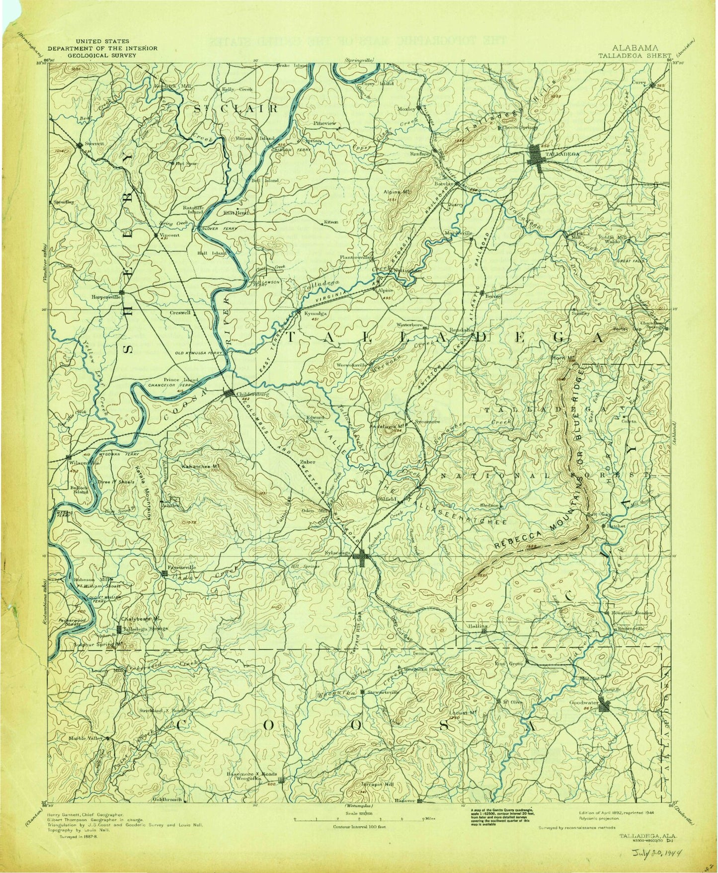
Historic 1892 Talladega Alabama 30'x30' Topo Map
Couldn't load pickup availability
Historical USGS topographic map of Talladega in the state of Alabama. Scale: 1:125000. Print size: 17" x 24"
This map was published in 1892 and is in the following counties: Clay, Coosa, Shelby, St. Clair, Talladega, Tallapoosa.
The map contains contour lines, roads, rivers, towns, streams, and lakes. Printed on high-quality waterproof paper with UV fade-resistant inks.
Contains the following named places: Allen Mountain, Alpine, Averett Branch, Bailey Branch, Bailey Mountain, Baker Branch, Barclay Branch, Bear Creek, Black Jack Ridge, Blue Spring Branch, Blue Spring Lake, Bon Air, Breastworks Creek, Buckhorn Branch, Bullocks Islands, Buzzard Island, Calcis, Carter Branch, Caudles Lake, Cedar Creek, Chalybeate Creek, Chalybeate Mountain, Charles Branch, Childersburg, Clear Creek, Cohabie Creek, Cohabie Mountain, Collins Bend, Coosa Court, Coosa Pines, Cosper Bend, Crumply Creek, Curry Island, Darby Branch, Dark Hollow, Deadening Mountain, Deer Lick Branch, Ditch Branch, Dry Branch, East Fork Tanyard Branch, Edwards Mountain, Edwards Pond, Ezekiel Branch, Fanning Branch, Fayetteville, Flagpole Mountain, Flat Branch, Flipper Creek, Forest Hills, Fourmile Creek, Fourmile Creek, Fulton Gap, Gantts Quarry, Glade Branch, Glover Mountain, Gooch Branch, Greasy Head Branch, Griffin Branch, Grissom Island, Grove Park, Gum Branch, Harbert Lake, Harpersville, Haw Branch, Hay Spring Branch, Hepzibah, Higdon Point, Hostler Creek, Howard Branch, Hurricane Creek, Indian Hill, Jackson Lake, Jackson Lake, Jennings Branch, Kahatchee Creek, Kauls Lake, Kelley Mountain, Lick Branch, Linder Mountain, Little Creek, Locust Creek, Lake Louise, Marble City Lake, Merkl Island, Mill Creek, Minor Terrace, Monk Creek, Moore Branch, Moore Mountain, Morgan Creek, Muddy Prong, Norman Mountain, Oak Grove, Old Glade Swamp, Oxbow Bend, Pennington Branch, Periwinkle Branch, Pinefiold Branch, Pinewood Terrace, Plantersville, Pope Branch, Quarry Mountain, Railroad Lake, Reedy Mountain, Riser Mountain, Rock Branch, Rocky Hollow, Shelton Creek, Slaughter Creek, Shocco Springs, Smith Island, Spear Branch, Spradley Branch, Sterrett, Stewart Branch, Sulphur Branch, Swept Creek, Sycamore, Tanyard Branch, Lake Tate, Tater Hill, Thomas Lake, Unity, Webb Branch, West Fork Tanyard Branch, Wilsonville, Winterboro, Wolf Pond, Yellow Branch, Yellowleaf Creek, York Mountain, A W Rayfield Dam, Cullen Thomas Dam, H Kaul Dam, Lane Dam, Tate Dam, Joiner Lake, Joiner Dam, Caudle Dam, Goodner Dam, Goodner Lake, Cleitts Dam, Cleitts Lake, Edwards Dam, Limbaugh Dam, Lake Limbaugh, Riser Dam, Riser Lake, Harkins Lake, Harkins Dam, Harpersville Lake Dam Number 1, Harpersville Lake Number 1, Kellys Lake, Jones Dam, Jones Lake, Harpersville Lake Number 2, Harpersville Lake Dam Number 2, Killough Dam, Killough Lake, Lake Donahoo, Donahoo Dam, Deerwood Lake, Deerwood Lake Dam, Acton Lake Dam, Acton Lake, Crim Lake Dam, Lake Dewitt, Hall Lake, Hall Dam, Baggetts Lake, Coosa Lodge Lake Dam, Ledbetter Lake Number 2, Ledbetter Lake Dam Number 2, Ledbetter Lake, Ledbetter Lake Dam Number 1, Lowery, Eureka Quarry, Chapple Branch, Alabama Marble Quarry, Alpine Bay, Amerines Corner, Andeluvia Mountain, Bakers Harbor, Belle Vista, Bethel, Briarfield, Bucky Peak, Camp Brownie, Camp Cosby, Campbells Crossroads, Cast Hill, Cave Mountain, Cedar Cove Estates, Cedar Creek Campground, Cedar Creek Marina, Center Hill, Childersburg Shopping Center, Clear Creek Estates, Clear Creek Harbor, Comerdale, Cook Mine, Cospers Bend, Country Club Estates, Coxs Pond, Crumplers Peak, Curry Branch, Deans, Fair Park, Feddisburg, Fort William Shopping Center, Glovers Point Park, Greasy Head Swamp, Heacock Mountain, Hillsman Gap, Howells Cove, Huttos Lake, Jack Mountain, Jonesview, Lake Joy, Jumpers Spring Branch, Katala Hills, Kings Chapel, Kingston, Kyser Leonard Lakefront Estates, Laniers Branch, Ledbetter, Lower Mud Creek, Mallory Mountain, Marble City Quarry, Marble Hill, McClungs Creek, Merkl Mountain, Mignon, Miles Quarry, Mullins Branch, Oden Gap