MyTopo
Historic 1934 The Dalles Oregon 30'x30' Topo Map
Couldn't load pickup availability
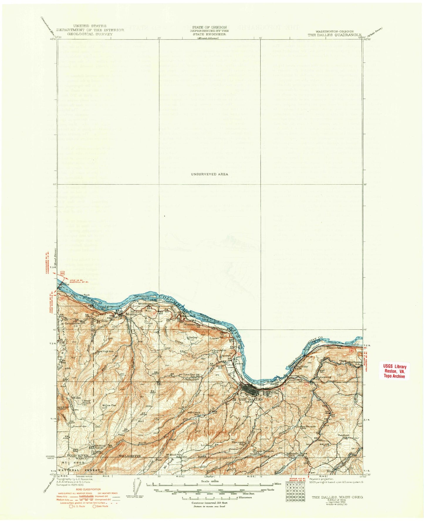
Historical USGS topographic map of The Dallesin the states of Oregon, Washington. Scale: 1:125000. Print size: 18" x 24"
This map was published in 1934 and is in the following counties: Hood River, Klickitat, Wasco.
The map contains contour lines, roads, rivers, towns, streams, and lakes. Printed on high-quality waterproof paper with UV fade-resistant inks.
Contains the following named places: Badger Creek, Big Eddy Substation, Campbell Creek, Celilo Converter Station, Lake Celilo, Chenoweth Creek, Company Hollow, Covington Point, Crates Point, Crates Point Light, Cushing Falls, Dry Creek, Dry Creek, Dry Fork, Dry Hollow, Dune, Dutch Flat, Eighteenmile Island, Evans Reservoir, Fairbanks Gap, Fivemile Lock Light, Foley Lakes Reservoir, Gooseberry Creek, Government Flat, Hidden Valley, Hood River Mountain, Huskey Flat, Indian Hollow, Indian Lake, Jameson Canyon, Kaser Ridge, Klindt Point, Liechti Pond, Lubbing Flat, Mayer State Park, McClure Lake, Memaloose Overlook, Memaloose State Park, Mill Creek, Mill Creek Falls, Mosier, Oak Flat, Port of the Dalles, Rocky Island, Rocky Prairie, Rowena Creek, Rowena Dell, Salisbury Slough, Sevenmile Hill, Seward Flat, Signal Hill, Sorosis Park, Spring Branch, Squally Point, Stanley Rock, Taylor Lake, The Hogback, Thousand Acre Pasture, Tooley Lake, Wasco Butte, Wasco Light, Whisky Gulch, Wicks Reservoir, Koberg Beach, Koberg Slough, Koberg Beach State Park, Rowena Crest, Liechti Pond Number Two, Ketchum Pond, Chenoweth Flat, Chenoweth, Sorosis Reservoir, Ryan Corner, Lone Pine Island, Hazeldell Orchards Reservoir, Seufert Dam, McDonald Reservoir, Wassen Pond, Wasco Guard Station, Trugg Reservoir, Pullens Pond, Orchid Camp, Bingen Gap, Rowena Gap, The Dalles Unit, McCall Point, Evans Dam, Cherry Heights, Crates, Fairbanks, Ortley, Panorama Point, Petersburg, Rowena, Baker Canyon, Beaver Creek, Blackburn Canyon, Breeds Flat, Brown Creek, Buck Hollow, Eightmile Creek, Fifteenmile Creek, Fir Mountain, Fivemile Creek, Honeysuckle Creek, Indian Creek, Japanese Hollow, Kellar Creek, Ketchum Reservoir, Ladore Creek, Lucky Canyon, Mill Creek Ridge, Mosier Creek, Neal Creek Lateral, North Fork Mill Creek, Pine Flat, Rock Creek, Round Prairie, Sheldon Ridge, Snakehead Creek, Snyder Canyon, South Fork Mill Creek, Spring Creek, Sugarloaf, Thompson Point, Threemile Creek, West Fork Mosier Creek, West Fork Neal Creek, Willow Flat, Woods Backbone, Sky Ranch Reservoir Number Three, Ketchum Dam, Ketchum Ranch, Bingen Range Channel, Obrist Grade, Suicide Grade, Smith Ridge, Mount Hood Flat, Seufert County Park, High Bridge, Sky Ranch Reservoir Number Four, Thompson Park, Howe Park, Wasco Lookout, The Dalles, Bingen Gap, Fivemile Rapids Light, Saddle Camp, Chenoweth Substation, Oregon Agricultural Experiment Station, Lewis and Clark Memorial, The Dalles Substation, Memaloose Island, Pulpit Rock, Historic Columbia River Highway State Trail, The Dalles Division, McClure Hill, Memaloose Safety Rest Area, Chatfield Hill, Marsh Hill, City of Mosier, City of The Dalles, Lone Pine Treaty Fishing Access Site, Stanley Rock Treaty Fishing Access Site, C and F Orchards, Foley Orchard, Hazel Dell Orchards, Moore Orchards, The Dalles Wastewater Treatment Plant, Mosier Wastewater Treatment Plant, The Dalles Columbia Gorge Water System, The Dalles Wicks Water Treatment Plant, Fort Dalles Rodeo Grounds, Mayer State Park Boat Ramp, Mosier Twin Tunnels, Port of The Dalles Marina, Port of The Dalles Marina Boat Ramp, The Dalles Transportation Network, The Dalles Country Club, Lake Celilo, Bingen Gap, Rowena Gap, Balch Lake, Beeks Canyon, Bingen, Bingen Gap, Bowman Creek, Canyon Creek, Catherine Creek, Chamberlain Lake, Dry Creek, Grayback Mountain, Hanson Creek, Hathaway Spring, Hess Park, Hewett Lake, Horseshoe Bend, Indian Point, Legall Spring, Little Klickitat River, Look Lake, Masondale Spring, Mill Creek, Paradise Spring, Pennington Spring, Quiney Flats, Rock Springs, Rocky Flat, Rowland Lake, Sheep Canyon, Soda Springs Campground, Summit Creek, Threemile Rapids Light, Willis Canyon, Threemile Point, Camp Five Spring, Stimpson Flats, Fill Pond, The Dalles Dam, Straight Point, Swale, Bristol, Dallesport, Klickitat Springs, Lyle, Wahkiacus, White Salmon, Town and Country Square, Northdalles Station, Burdoin Mountain, Jewett Creek Park, Pioneer Park, Frasier Creek, Snyder Swale, Appleton, Bird Creek