MyTopo
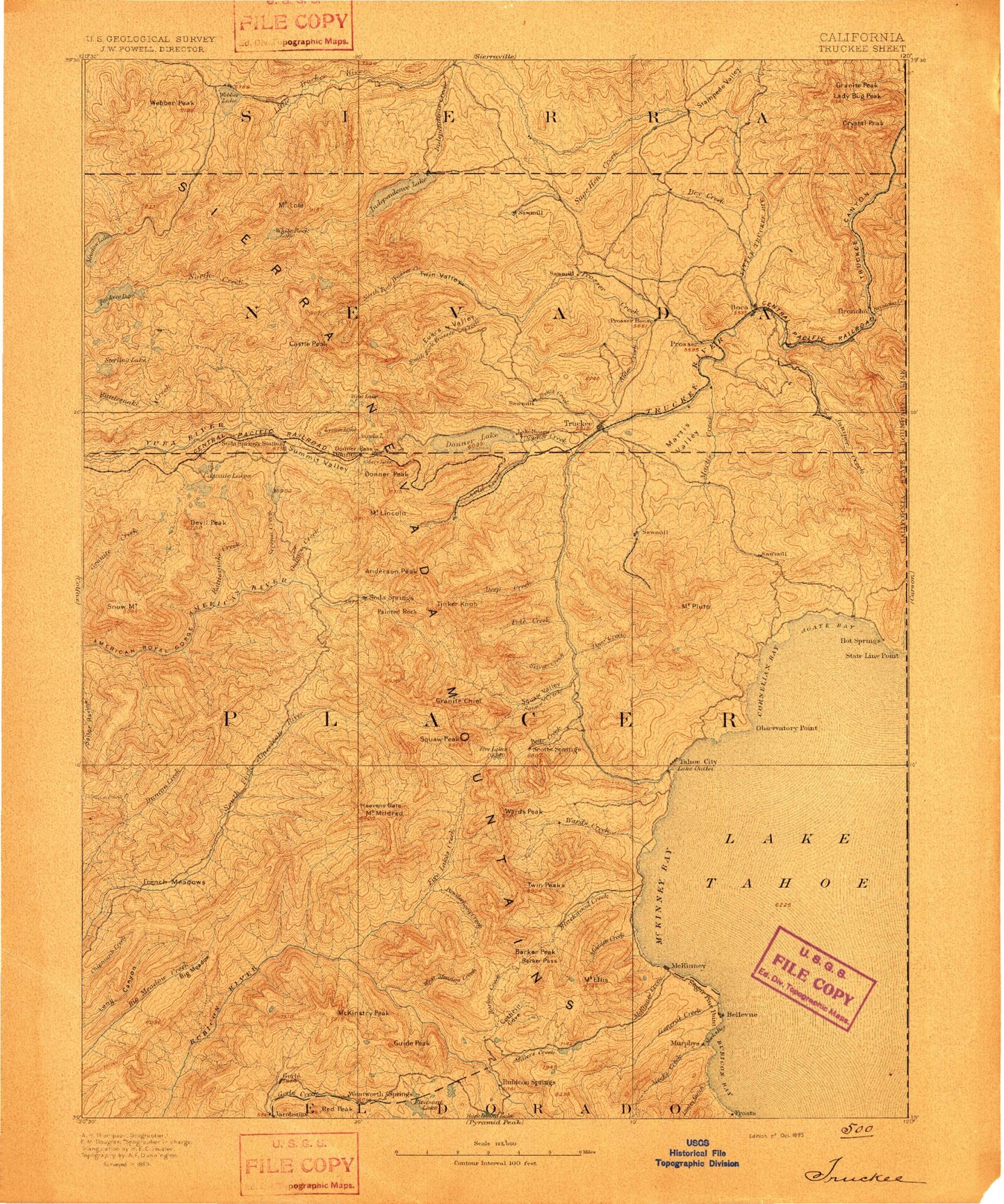
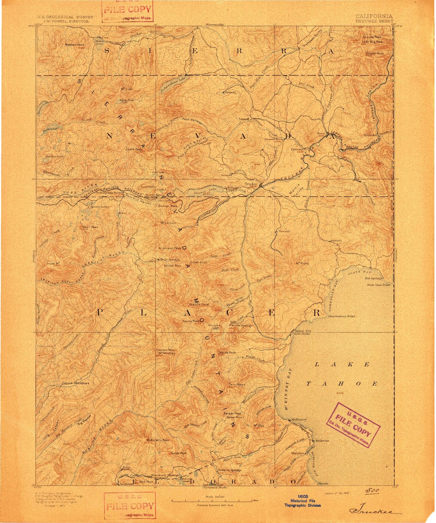
Historic 1893 Truckee California 30'x30' Topo Map
Couldn't load pickup availability
Historical USGS topographic map of Truckee in the state of California. Scale: 1:125000. Print size: 17" x 24"
This map was published in 1893 and is in the following counties: Carson City (city), Douglas, El Dorado, Nevada, Placer, Sierra, Washoe.
The map contains contour lines, roads, rivers, towns, streams, and lakes. Printed on high-quality waterproof paper with UV fade-resistant inks.
Contains the following named places: Acid Flat, Ahart Campground, Alder Hill, Alpine Meadows, Anderson Mine, Antone Meadows, Bald Mountain, Barker Creek, Barts Valley, Bear Creek, Bear Creek Campground, Bear Pen Creek, Bear Trap Cabin, Bear Valley, Bennett Flat, Big Chief, Big Sluice Box, Boca Dam, Boca Hill, Boca Reservoir, Boca Ridge, Brush Creek, Buck Island Lake, Buck Meadow, Buckskin Creek, Bugle Lake, Bull Flat, Buttes Area Camp, Buzzard Roost, Buzzard Roost Lake, Cabin Creek, Camp Pahatsi, Cascade Lakes, Catfish Lake, Chalk Bluff, Cold Creek, Cold Springs Campground, Coldstream Valley, Cottonwood Creek, Deep Canyon, Deep Creek, Deer Creek, Dellar Meadow, Devils Peak, Devils Peak, Dolly Creek, Donner Creek, Donner Memorial State Park, Donner Monument, East Boca Canyon, Ellis Creek, Lake Estelle, Fern Lake, Fir Crags, Fisher Lake, Five Lakes, Five Lakes Creek, Fordyce Lake, French Meadow, Gates Cabin, Gooseneck Flat, Granite Peak, Grayhorse Creek, Grayhorse Valley, Guide Peak, Hampshire Rocks Campground, Handy Camp, Hells Half Acre, Hidden Lake, High Loch Leven Lake, Hole-In-Ground, Huntley Mill Lake, Jerrett Creek, Jerrett Peak, Jerry Lake, Joerger Ranch, Jones Valley, Jones Valley, KT-22, Kidd Lake, Kilborn Lake, Kingvale, Lacey Valley, Laddies Cove, Ladybug Peak, Lewis Campground, Lily Pond, Little Chief, Little Duncan Canyon, Little McKinstry Meadow, Little Powderhorn Creek, Little Sluice Box, Long Lake, Long Lake, Long Valley, Lookout Mountain, Lost Emigrant Mine, Lower Castle Creek, Lower Lola Montez Lake, Magonigal Camp, McKinstry Lake, McKinstry Meadow, McKinstry Peak, McKinstry Trail, Meadow Lake, Meadow Lake Hill, Miller Creek, Miranda Cabin, Moscove Meadow, Mossy Pond, Mount Rose Trail, Mountain Meadow, Mud Lake, Mud Lake, Mud Lakes, Murphy Cabin, Murry Camp, Mystic Canyon, Nancy Lake, Neck Meadow, North Creek, Oak Flat, Old Schaeffer Camp, Painted Rock, Palisade Creek, Palisade Lake, Paradise Valley, Placer Queen Mine, Mount Pluto, Powderhorn Creek, Puny Dip Canyon, Red Cliffs, Red Mountain, Rice Creek, Rocky Canyon, Rocky Wash, Royal Gorge River, Sailor Canyon Mine, Sailor Flat Trail, Sailor Meadow, Sand Ridge, Sand Ridge Lake, Scott Peak, Serena Creek, Silver Creek, Silver Creek Campground, Silver Peak, Coppins Meadow, French Meadows, Old Schaeffer Mill, Pole Creek, Sailor Canyon, Snow Mountain, Soda Springs, Spider Lake, Squaw Creek, Squaw Valley, Stampede Dam, Station Creek, Steamboat Canyon, Steamboat Mountain, Steamboat Trail, Lake Sterling, Sunflower Hill, Tahoe State Recreation Area, The Pinnacles, Thunder Cliff, Trinidad Mine, Trout Creek, Twin Crags, Upper Hell Hole, Upper Jones Valley, Upper Lola Montez Lake, Wabena Creek, Walker Mine, Ward Creek, Ward Peak, Warm Lake, Watson Lake, Mount Watson, Webber Lake, Webster Flat, Wentworth Springs Campground, West Meadow Creek, White Rock Creek, White Rock Lake, Wildcat Canyon, Willow Creek, Lake Winifred, Worn Mill Canyon, X-Ray Mine, Euer Saddle, Burnt Flat, Devils Oven Lake, Perazzo Canyon, Bronco Creek, Canyon Two, Canyon Twentytwo, Canyon Twentythree, Canyon Twentyfour, Canyon Three, Canyon Four, Ice Lakes, Little Robinsons Valley, Page Meadows, Verdi Peak, Agate Bay, Anderson Peak, Andesite Peak, Andesite Ridge, Lake Angela, Azalea Lake, Barker Meadow, Barker Pass, Barker Peak, Barts Creek, Basin Peak, Baumann Trail, Bear Lake, Big Meadow, Billy Hill, Billy Mack Canyon, Billy Mack Flat, Blackwood Creek, Blackwood Ridge, Boreal Ridge, Brockway Summit, Buck Lake, Buck Meadows, Buck Ridge, Bunker Hill, Bunker Lake, Bunker Meadow, Burned Hill, Burton Creek, Camp Wasiu