MyTopo
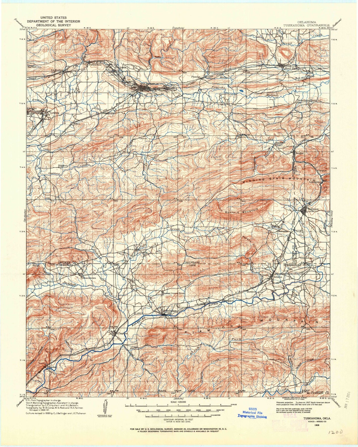
Historic 1908 Tuskahoma Oklahoma 30'x30' Topo Map
Couldn't load pickup availability
Historical USGS topographic map of Tuskahoma in the state of Oklahoma. Scale: 1:125000. Print size: 18" x 24"
This map was published in 1908 and is in the following counties: Latimer, Le Flore, McCurtain, Pushmataha.
The map contains contour lines, roads, rivers, towns, streams, and lakes. Printed on high-quality waterproof paper with UV fade-resistant inks.
Contains the following named places: Rock Creek, Albion, Albion Creek, Alexander Trail, Anderson Creek, Austin Lake, Baker Hollow, Baker Mountain, Baldwin Prairie, Bandy Creek, Bear Den Hollow, Bear Mountain, Bear Suck Knob, Beaver Creek, Bengal, Black Fork Lateral, Black Fork Trail, Blue Mountain, Bobcat Ridge, Boggs Hollow Creek, Boggy Springs Hollow, Boiling Springs Creek, Bridge Hollow, Bridge Set Creek, Bryant Branch, Buffalo Creek, Buffalo Creek, Buffalo Mountain, Bull Hill, Buzzard Gap, Lake Carl Albert, Cedar Creek, Cedar Creek, Clayton, Clayton Lake, Clayton Lake State Recreation Area, Clayton Trail, Clear Creek, Clear Creek, Clear Creek Trail, Coal Creek, Coon Creek, Coopers Branch, Coopers Hollow, Courthouse Gap, Cripple Mountain Trail, Crumb Creek, Crumb Creek Trail, Cunneo Tubby Creek, Devils Hollow, Dripping Vat Mountain, Dry Creek, Dry Creek, Eightmile Mountain, Evangelistic Tabernacle, Ferguson Trail, First Mountain, Flagpole Mountain, Garland Trail, Gobblers Knob, Gobblers Knob, Gowen, Granny Graham Mountain, High Rock Trail, High Top, Hog Creek, Hoot Owl Creek, Horse Creek, Hurd Creek, Hurd Creek Trail, Jackfork Creek, Jackson Creek, Kiamichi Camp, Limestone Ridge, Little Buffalo Creek, Little Cedar Creek, Little Fourche Maline, Little High Top, Little Ridge, Lloyd Church Lake, Long Boggs Hollow, Long Creek, Long Creek Lake, Long Prairie, Maxwell Creek, Middle Mountain, Middle Mountain, Middle Ridge, Minnetonka Camp, Lake Nanih Waiya, Nick Brown Creek, North Fork Walnut Creek, North Gaines Creek, North Jackfork Creek, North Long Creek, North Peachland Creek, Old Choctaw Indian Council House, Panola, Patterson, Peachland Creek, Peal Creek, Peterson Creek, Pigeon Creek, Pine Creek, Polecat Creek, Potato Hills, Prairie Creek, Pushmataha County State Game Refuge, Red Oak, Red Oak Mountain, Red Oak Peak, Red Oak Ridge, Rock Creek, Rock Creek, Rock Creek, Round Canyon Hollow, Round Top, Second Mountain, South Fork Walnut Creek, South Gaines Creek, South Long Creek, South Peachland Creek, Spring Creek, Spring Creek Gap, Talihina, Lake Talihina, Tuskahoma, Umbrella Rock, Uphill Creek, Uphilly Bowers Trail, Walnut Creek, Walters Mule Trail, Waterworks Picnic Area, Lake Wayne Wallace, Weber Mountain, West Compton Hollow, West Fork Anderson Creek, West Fork Rock Creek, Wilburton, Wildhorse Creek, Wildhorse Trail, Wolf Mountain, Yancy Mountain, Yanush, Bowers, Center Point, Chilli, Compton, Damon, Degnan, Drumb, Fewell, Higgins, Kiamichi, Lamberson, Sardis, Stanley, Lutie, Bear Creek, Compton Hollow, Crusher Hollow, Henry G Mountain, K Trail, Little Buzzard Creek, Rock Creek, Latimer County, Kiamichi Fish Farm, Denman, Township of Tuskahoma, Rock Creek Site 2 Dam, Rock Creek Site 2 Reservoir, Rock Creek Site 3 Dam, Rock Creek Site 3 Reservoir, Rock Creek Site 1 Dam, Rock Creek Site 1 Reservoir, Fourche Maline Creek Site 1 Dam, Fourche Maline Creek Site 1 Reservoir, Fourche Maline Creek Site 2 Dam, Fourche Maline Creek Site 2 Reservoir, Fourche Maline Creek Site 3 Dam, Fourche Maline Creek Site 3 Reservoir, Fourche Maline Creek Site 4 Dam, Fourche Maline Creek Site 4 Reservoir, Fourche Maline Creek Site 7 Dam, Fourche Maline Creek Site 7 Reservoir, Fourche Maline Creek Site 8 Dam, Fourche Maline Creek Site 8 Reservoir, Fourche Maline Creek Site 9 Dam, Fourche Maline Creek Site 9 Reservoir, Fourche Maline Creek Site 10 Dam, Fourche Maline Creek Site 10 Reservoir, Fourche Maline Creek Site 12 Dam, Fourche Maline Creek Site 12 Reservoir, Fourche Maline Creek Site 13 Dam, Fourche Maline Creek Site 13 Reservoir, Fourche Maline Creek Site 14 Dam, Fourche Maline Creek Site 14 Reservoir, Talihina Lake Dam, Fourche Maline Creek Site 5 Dam, Fourche Maline Creek Site 5 Reservoir, Carlton Dam, Lake Carlton, Martha Lingenfelter Lake Dam, Martha Lingenfelter Lake, Nanih Waiya Lake Dam, Clayton Dam, Dresser Lake Dam, Dresser Lake, Rock Creek Site 4 Dam, Rock Creek Site 4 Reservoir, Fourche Maline Creek Site 11 Dam, Fourche Maline Creek Site 11 Reservoir, Boiling Springs Site 1 Dam, Boiling Springs Site 1 Reservoir, Oknoname 06003 Dam, Oknoname 063003 Reservoir, Oknoname 077001 Dam, Oknoname 077001 Reservoir, Oknoname 077002 Dam, Oknoname 077002 Reservoir, Oknoname 077003 Dam, Oknoname 077003 Reservoir, Oknoname 077004 Dam, Oknoname 077004 Reservoir, Oknoname 077005 Dam, Oknoname 077005 Reservoir, Oknoname 077006 Dam, Oknoname 077006 Reservoir, Oknoname 077007 Dam, Oknoname 077007 Reservoir, Oknoname 077008 Dam, Oknoname 077008 Reservoir, Oknoname 077009 Dam, Oknoname 077009 Reservoir, Oknoname 127005 Dam, Oknoname 127005 Reservoir


