MyTopo
Historic 1891 Wabuska Nevada 30'x30' Topo Map
Couldn't load pickup availability
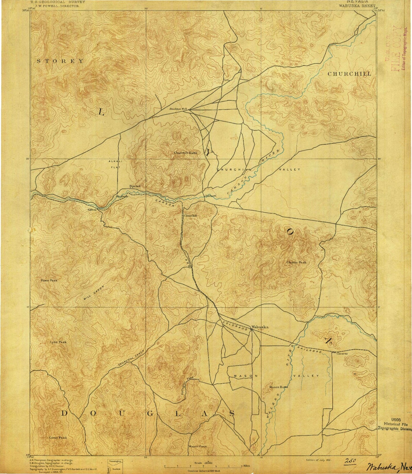
Historical USGS topographic map of Wabuska in the state of Nevada. Scale: 1:125000. Print size: 17" x 24"
This map was published in 1891 and is in the following counties: Churchill, Douglas, Lyon, Storey.
The map contains contour lines, roads, rivers, towns, streams, and lakes. Printed on high-quality waterproof paper with UV fade-resistant inks.
Contains the following named places: Adrian Valley, Blackhawk Mine, Boyle Tunnel, Buckland Ditch, Bull Canyon, Campbell Ditch, Carson Hill, Churchill Butte, Churchill Narrows, Churchill Valley, Cinder Mountain, Cleaver Peak, Clifton, East Campbell Ditch, Gallagher Pass, Gooseberry Mine, Hinkson Slough, Houghman and Howard Ditch, J W Ranch, Joggles Ditch, Joggles Slough, Koch Ditch, Lincoln Flat, Martha Washington Shaft, Mason Butte, Mason Pass, Mason Valley Wildlife Management Area, Merritt Ditch, Mill Canyon, Mineral Canyon, Nichols-Merritt Ditch, Parker Butte, Perazzo Slough, Perk Slough, Ramsey Mine, Ramsey-Comstock Mine, Rosetta Mine, Ruth Mine, Sand Canyon, Sand Ridge Ditch, Sky Lateral, Spragg-Alcorn-Bewley Ditch, Sunrise Basin, Sunrise Camp, Sunrise Pass, Table Mountain, The Narrows, Thompson Smelter, Wabuska, Wabuska Drain, West Campbell Ditch, West Hyland Ditch, White Sage Flat, Stagecoach Valley, Rock Dam Ditch Number 1, McLeod Hill, San Juan Hill, Desert Mountains, McGowan Corner, May Day Mine, Pony Meadows Mine, Bar G Ranch, Landolf Ranch, Neck Yoke Ranch, Lazy S Ranch, Ritter Ranch, Churchill Peak, Campbell, Poli Ranch, Bolster Ranch, Clark Ranch, Everett Ranch, Cooney Reservoir, Artesia, Smiths Valley, Chaves Ranch, Parker Ranch, Gooseberry Mill, Cinder Mountain Mine, Lizard Mine, San Juan Mine, Windy Day Mine, Mason Valley Ranch, JJ Ranch, Badger Mining District, Iron Mountain Mining District, Fort Churchill Cooling Ponds, Blackrock, Churchill Canyon, Mount Como, Guild Placer Mines, Hercules Mine, Rawe Peak, Susans Bluff, Campbell Ranch, Wishart Hill, Carp Dam, Desert Station, Blackbird Point, Evans Island, Drum Point, Sixmile Beach, Rock Dam Ditch, Misfits Flat, Virginia Beach, Fishermans Point, Stagecoach, California Emigrant Trail, Clifton Flat, Martin Canyon, Meeker Pond, Blackhawk Canyon, Dyke Adit, Christianson Shaft, Stockton Flat, Lahontan State Recreation Area, Lyon Peak, Silver Springs Beach, Minnesota Mine, Churchill Beach, Como Mining District, Como Mines, Talapoosa Mines, Ramsey Mining District, Buckskin Mining District, Dayton Iron Mine, Wabuska Quarry, John C Fremont Picnic Area, Samuel Bucklands Campground, Horsemans Point, Silver Springs Marina, Jupiter Mine, B H and V Mine, Churchill Mining District, Talapoosa Mining District, McArthur Mine, Goose Valley Mine, Appian Siding, Churchill, Como, Lux, Talapoosa, Fort Churchill Historic State Monument, Mason Valley, Ramsey Station, Davis Station, Greenville, Red Mountain Mining District, Washout, Big Meadows, Mountain of Hieroglyphics, Big Bend of the Carson, Mohawk Mine, Whinn Shaft, Dayton Township, Lahontan Dam, Lahontan Reservoir, Silver Springs, Weeks Toll Ranch, Break a Heart Ranch Number 1, Pearl Harbor Mine, Pony Bob Haslam Group Use Area, Lyon County, Singatse Range, Lahontan Boat Landing, Lahontan State Game Refuge, Yerington Mill Dam, Gooseberry Mine Tailings Dam, Gooseberry Tailings Reservoir, Yerington Mill Pond AA Dam, Yerington Mill Pond BB Dam, Yerington Mill Number Two Dam, Stone Cabin Mine, Dayton Division, Silver Springs Division, Ramsey Canyon, L - M Feedlot, Fremont Lookout, Ramsey Summit