MyTopo
Historic 1889 Wamego Kansas 30'x30' Topo Map
Couldn't load pickup availability
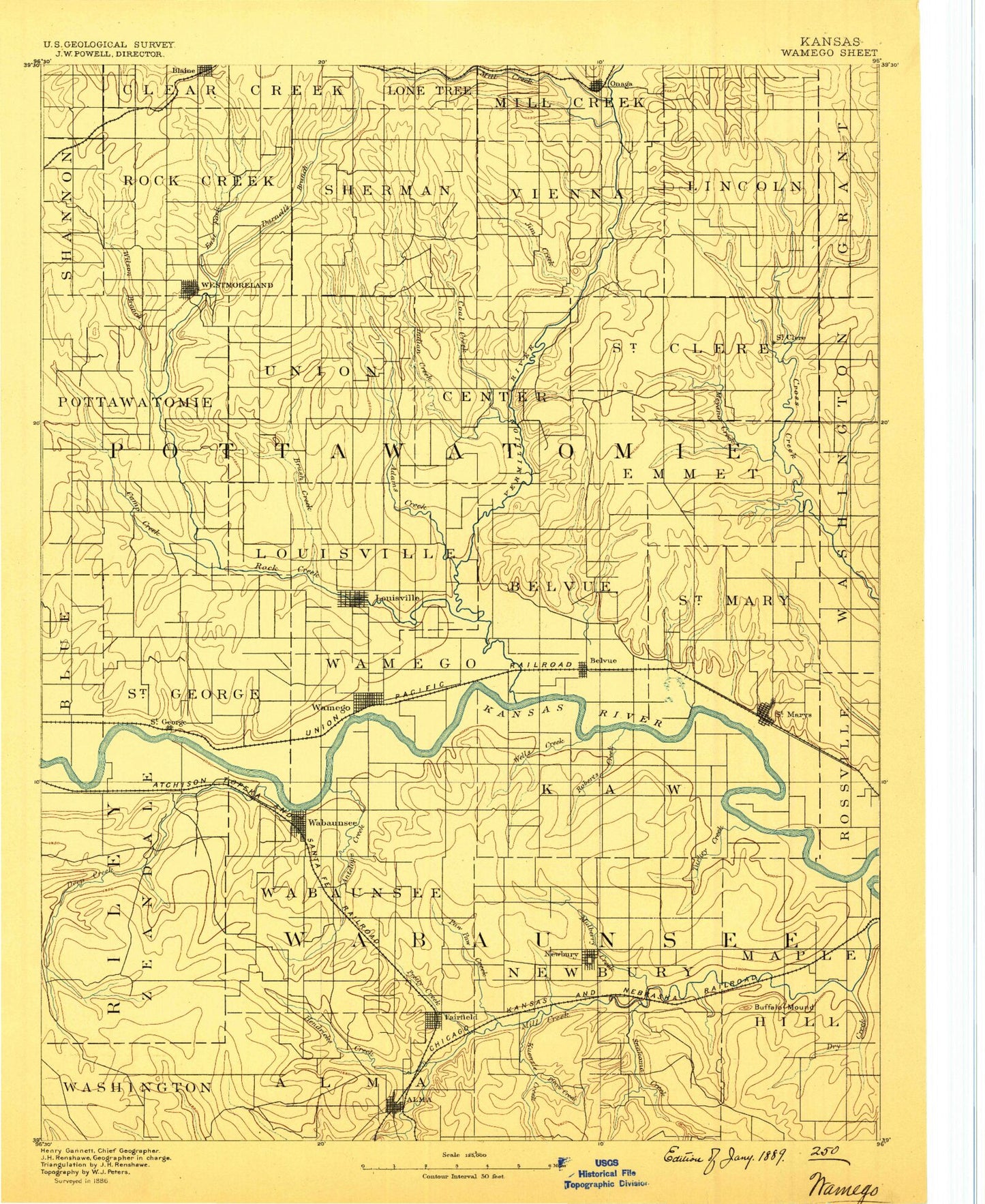
Historical USGS topographic map of Wamego in the state of Kansas. Scale: 1:125000. Print size: 17" x 24"
This map was published in 1889 and is in the following counties: Jackson, Pottawatomie, Riley, Shawnee, Wabaunsee.
The map contains contour lines, roads, rivers, towns, streams, and lakes. Printed on high-quality waterproof paper with UV fade-resistant inks.
Contains the following named places: Blaine, Hise Creek, Pleasant Run Creek, Township of Pottawatomie, Pottawatomie County State Park Number One, Township of Rock Creek, Wilson Creek, Lazy Creek, Rock Creek, Darnells Creek, Township of Union, Westmoreland, Mount Ephraim, Dutch Hollow, Township of Sherman, Jim Creek, Coal Creek, Indian Creek, East Fork Adams Creek, Mill Creek, Adams Creek, Township of Center, Onaga, Spring Creek, Township of Lincoln, Township of Vienna, Township of Saint Clere, Little Noxie Creek, Bartlett Creek, Big Noxie Creek, Riley Lakes, Mud Creek, Hopkins Creek, Elm Slough, Township of Louisville, Township of Saint George, Brush Creek, Boxelder Creek, Elm Slough, Louisville, Pomeroy Creek, Township of Belvue, Lost Creek, Polly Creek, Township of Emmett, Long Branch, Little Cross Creek, Illinois Creek, Emmett, Bourbonnais Creek, Riley Creek, Deep Creek, Township of Zeandale, Sand Creek, Blood Creek, Blackjack Creek, Plum Creek, Lake Elbo, School Creek, Sand Creek, Saint George, School Creek, Zeandale, Deep Creek, Emmons Creek, Township of Wabaunsee, Wamego, Coldwater Creek, Antelope Creek, Wabaunsee, Township of Wamego, Belvue, Roberts Creek, Wells Creek, Little Wells Creek, Township of Kaw, Doyle Creek, Willard Creek, Saint Marys, College Creek, Turkey Creek, Tabor Hill, South Branch Deep Creek, East Branch Deep Creek, Tabor Valley, Hendricks Creek, Alma, Phillips Creek, Clapboard Canyon, Pretty Creek, Paw Paw Creek, Pierce Creek, McFarland, Paxico, Spring Creek, Newbury, Mulberry Creek, Buffalo Mound, Maple Hill, Dog Creek, Dry Creek, South Branch Mill Creek, West Branch Mill Creek, Township of Alma, Kuenzli Creek, Joe Woody Branch, Township of Newbury, Snokomo Creek, Pottawatomie Number One State Fishing Lake and Wildlife Area, McFarland Detention Dam, Vermillion Creek, Flush, Laclede, Aikins, Saint Clere, Swamp Angel, Pillsbury Crossing, Vera, Pottawatomie County, Township of Maple Hill, Township of Saint Marys, City of Alma, City of Belvue, City of Emmett, City of McFarland, City of Louisville, City of Maple Hill, City of Onaga, City of Paxico, City of Saint George, City of Saint Marys, City of Wamego, City of Westmoreland, Paxico Sewer Treatment Plant, Alma Sewer Treatment Plant, Maple Hill Wastewater Treatment Plant, Belvue Wastewater Plant, Saint George Wastewater Treatment Plant, Saint Marys Wastewater Treatment Facility, Westmoreland Wastewater Treatment Facility, Wamego Wastewater Treatment, McFarland Sewer Treatment Plant, Onaga Wastewater Treatment Facility, Wamego Industrial Park, Kansas Department of Transportation Wabaunsee County Rest Area, Onaga Fairgrounds, Wabaunsee County Fairgrounds, Louisville Wastewater Plant, Wabaunsee County Sewer District Number 1 Wastewater Treatment Plant, Wamego Municipal Power Plant, Bretz's Mobile Home Park, Humdinger Trailer Park, In the Field Mobile Home Park, Keating Mobile Home Park, Mobile Villa Trailer Court, Riverside Mobile Home Park, Saint George Mobile Home Park, Walnut Grove Mobile Home Park, Mill Creek Campground and Recreational Vehicle Park, Wamego Country Club, Saint Marys Public Golf Course, Interstate 70 Weigh Station 21W, Interstate 70 Weigh Station 22W, Alma Co - Operative Oil Association Grain Elevator Number 1, Farmers Union Co - Operative Business Association Grain Elevator Number 1, Farmers Union Co - Operative Business Association Grain Elevator Number 2, Farmers Union Co - Operative Business Association Grain Elevator Number 3, Farmers Co - Operative Association Grain Elevator Number 4