MyTopo
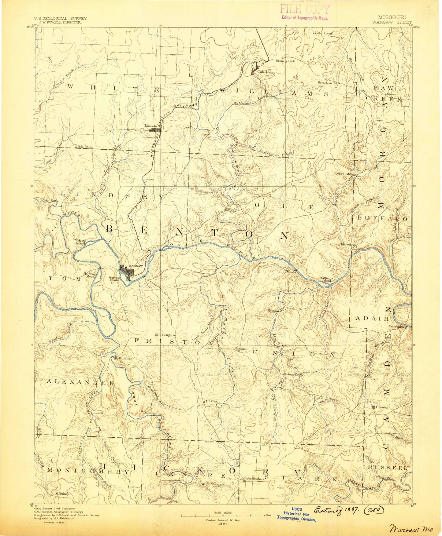
Historic 1887 Warsaw Missouri 30'x30' Topo Map
Couldn't load pickup availability
Historical USGS topographic map of Warsaw in the state of Missouri. Scale: 1:125000. Print size: 17" x 24"
This map was published in 1887 and is in the following counties: Benton, Camden, Hickory, Morgan, St. Clair.
The map contains contour lines, roads, rivers, towns, streams, and lakes. Printed on high-quality waterproof paper with UV fade-resistant inks.
Contains the following named places: Archer Creek, Attners Bluffs, Avery, Barber Hollow, Bauer Branch, Bell Branch, Big Buffalo Cove, Bird Branch, Bird Hollow, Blue Branch, Blue Branch, Bone Hollow, Boone Branch, Brickley Hollow, Brown Branch, Brushy Creek, Brushy Hollow, Buck Branch, Buck Hollow, Buckley Hollow, Burbick Hollow, Butter Hollow, Button Hollow, Buzzard Cave Bluff, Byler Branch, Byler Branch, Canfield Ridge, Cantrell Hollow, Carman Creek, Church House Hollow, City Union Mission Camp, Cobb Bluff, Coffee Hollow, Cold Springs, Cole Camp, Cole Camp Creek Arm, Cole Camp Junction, Cole Camp Station, Conley Branch, Cooney Creek, Cover Branch, Crawfish Hollow, Cross Timbers, Davenport Hollow, Deer Creek, Deer Creek Arm, Dell Junction, Devils Backbone, Ditler Creek, Dry Branch, Duncans Point, Durham Hollow, Duroc Bay, Edmonson, Edwards, Elkenberry Hollow, Elkins Hollow, Feaster Branch, Flat Rock Creek, Flemming Branch, Franks Hollow, Fristoe, Fristoe Branch, Gist Ridge, Goss Hollow, Gross Point, Hay Hollow, Helton Branch, Horn Branch, Indian Creek, Indian Creek, Indian Hill, Jack Branch, Jennings Hollow, Johnson Branch, Kaysinger Bluff, Laird Bluff, Lakeview Heights, Lemon Branch, Lick Creek, Limestone Ridge, Lincoln, Little Buffalo Creek, Little Deer Creek, Little Hogles Creek, Little Mill Creek, Little Pomme de Terre River, Little Tebo Creek, Little Turkey Creek, Little Valley Hollow, Lively, Macks Creek, McCalls Branch, McDavid Hollow, Miller Ridge, Mining Hollow, Mize Hollow, Mockingbird Hill, Montgomery Hollow, Morriss Creek, Mossy Creek, Mount Hulda, Muddy Hollow, Negro Creek, North Fork Blue Branch, Oak Hunter Hollow, Old Fredonia, Otten Branch, P D Creek, Pearson Branch Ridge, Pennel Branch, Phillips Branch, Picnic Hollow, Pine Cove, Pole Hollow, Pom-o-sa Heights, Pomme de Terre Hall, Possum Trot Hollow, Powell Hollow, Prairie Creek, Rainy Creek, Rise Branch, Ritter Branch, Riverview, Rob Hollow, Ross Creek, Salley Branch, Sam Allen Hollow, Sarvis Branch, Sawmill Hollow, Scott Hollow, Seedtick Mine, Shawnee Bend, Short School Hollow, Sloan Hollow, South Fork Blue Branch, Spring Branch, Spring Branch Cove, Spring Valley Creek, Spry Hollow, Starks Creek, Stevenson Hollow, Sugar Creek, Sugarcamp Hollow, Sugarcamp Hollow, Sullens Hollow, Summers Hollow, Sweatman Hollow, Thatcher Hollow, Tick Ridge, Townes Hollow, Trinity Hollow, Turkey Creek Cove, Turkey Hollow, Turnip Top Hollow, Turpin Branch, Valley View, Vance Branch, Warsaw, Wayne Hollow, Whig Creek, Whitakerville, White Branch, White Branch, Wigwam Hollow, Williams Creek, Wilson Hollow, Wolf Branch Hollow, Wrights Island, Harry S Truman Dam, Big Buffalo Creek, Boylers Mill, Cole Camp Creek, Duran Creek, Knobby Creek, Mattock Hollow, Minnow Branch, Pomme de Terre River, Quincy, Sterett Creek, Sugarcamp Hollow, Tebo Creek, Turkey Creek, Zora, Gover Branch, Gabriels Mills, Opportunity Farms, School House Hollow, Wilson Hollow, Cutting Hollow, Rednar Hollow, Roberts Branch, Smith Hollow, Haywood Hollow, Bates Hollow, Mayberry Hollow, Mark Branch, Golden Goose Cove, Cable Ridge, Freeman Hollow, Horsethief Bluff, Leeder Bluff, Macks Camp, Teal Bend, Big Bend Acres, Cooper Hollow, Hilda, Bentonville, Crest, Crockerville, Hastain, Jordan, Knobby, Majorville, Palo Pinto, Racket, Sagrada, Santiago, Tackner, Walkers Corner, White Cloud, Wisdom, Osage Bluff Public Use Area, Fairfield Public Use Area, Carpenter Memorial State Wildlife Area, Big Buffalo Creek State Wildlife Area, Mount Hulda State Wildfile Area, Jockey City Corners, Moles Cave State Wildlife Area, Camp Oakledge, Sterett Creek Public Use Area, Shawnee Bend Public Use Area, Bledsoe Ferry Public Use Area, Cedar Hills Golf Course, Kaysinger Bluff Public Use Area, Thibaut Point Public Use Area