MyTopo
Historic 1903 Waukon Iowa 30'x30' Topo Map
Couldn't load pickup availability
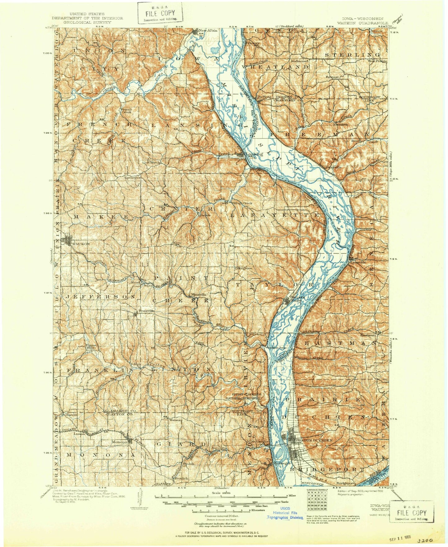
Historical USGS topographic map of Waukonin the states of Iowa, Minnesota, Wisconsin. Scale: 1:125000. Print size: 18" x 24"
This map was published in 1903 and is in the following counties: Allamakee, Clayton, Crawford, Grant, Vernon.
The map contains contour lines, roads, rivers, towns, streams, and lakes. Printed on high-quality waterproof paper with UV fade-resistant inks.
Contains the following named places: Bear Creek, Big Lake, Big Slough, Bloody Run, Church, Clark Creek, Clear Creek, Clear Creek, Cota Creek, Delphey Island, Dousman Creek, Dry Hollow Creek, Duck Lake, Effigy Mounds National Monument, Erickson Spring Branch, Faegre Prairie, French Creek, Froelich, Gateway Park, Giard, Hardin, Harpers Ferry, Harpers Slough, Henderson Island, Hickory Creek, Irish Hollow Creek, Jackson Island, Jones Creek, Kains Siding, Lansing, Lansing Ridge, Little Paint Creek, Luana, Marquette, McDonald Slough, McGregor, Middle Slough, Minnesota Slough, Monona, Mooney Ridge, Mount Hosmer Park, Murray Island, New Albin, Norfolk Creek, Oil Spring Creek, Paint Creek, Pigpen Slough, Pool Slough, Rossville, Ryan Island, Saint Paul Slough, Silver Creek, Springs Branch Creek, Suttle Creek, Teeple Creek, Trout Run, Upper Iowa River, Village Creek, Volney, Waterville, Waukon, Wexford Creek, Williams Creek, Wood Slough, Yellow River, Yellow River State Forest, Fish Farms Mounds Wildlife Management Area, Lansing Big Lake Public Hunting Area, Little Paint Creek Public Hunting Area, Waukon City Park, Capoli Mill, Johnsons Port, Manchester, Yellow River, West Yards, New Albin Big Lake Public Hunting Area, Founders Pond, Hanging Rock, Eagle Rock, Fire Point, Nezekaw Point, Beulah, Dalby, Egan, Eldergrove, Elon, Ion, Lycurgus, Lyndale, Maud, McGregor Heights, Sixteen, Thompson Corner, Village Creek, Watson, Waukon Junction, Allamakee County, Penny Springs, Township of Center, Township of Fairview, Township of Franklin, Township of French Creek, Township of Giard, Township of Iowa, Township of Jefferson, Township of Lafayette, Township of Lansing, Township of Linton, Township of Makee, Township of Mendon, Township of Monona, Township of Paint Creek, Township of Taylor, Township of Union City, Lock and Dam 9, Pool 9, McDonald Slough, Taylor Lakes, Japan Slough, Mud Hen Lake, Off Slough, Waukon Junction Wildlife Management Area, Luster Heights Work Camp, Joyce Lake, Point Ann, Bloody Run County Park, Rittenhouse Lake, Butler Lake, Gimmel Lake, Martelle Lake, Heytmans Station, Mud Hen Lake Wildlife Management Area, Bridge Sixteen Canoe Access, Waterville Farm, Waterville Pines Park, French Creek Wildlife Management Area, Upper Iowa Canoe Access, Clear Creek Wildlife Management Area, Lansing Wildlife Management Area, Kains Lake Wildlife Management Area, Blackhawk Point Wildlife Management Area, New Albin Big Lake Wildlife Management Area, Pool Slough Wildlife Management Area, Allamakee County Home Park, Waukon Junction, New Albin, Lansing Valley Mobile City, Rivertown Mall, Lansing, Hayes Lake Roadside Park, Rossville Park, Interstate Power Fishing Access Area, Clear Creek Park, Red Barn Resort and Campground, Nobles Island, Harpers Ferry Bluffview, Waukon Golf and Country Club, Allamakee County Fairgrounds, Andy Mountain Campground, Yellow River State Forest Trail, Harpers Ferry City Park, Bloody Run Wildlife Management Area, Monona, Gateway Park Campground, Monona City Park, Froelich Historic Site, Spook Cave and Campground, McGregor River Front Park, McGregor, Marquette, Tri-Club Golf Club, Luana, Luana Softball Diamond, Northeast Iowas First White Farmer Historical Marker, Beginning of Old Military Trail Historical Marker, Giard Tract State Historical Marker, Marquette City Park, City of Harpers Ferry, City of Marquette, City of McGregor, City of New Albin, City of Monona, City of Lansing, City of Luana, City of Waterville, City of Waukon, City of Monona Wastewater Treatment Plant, Fish Lake, Lost Channel, Launsom Lake, Phillipi Lake, Conway Lake, Gun Lake, Hummingbird Slough, Crooked Slough, Billys Slough, McGregor Administrative Site, Minnesota Slough, Pigpen Slough, Upper Iowa River, Little Slough, Lock and Dam No, Ambrough Slough, Anderson Ridge, Asbury Ridge, Bates Hollow, Battle Hollow, Battle Island, Battle Slough, Bean Hollow, Bean Hollow, Bergman Island, Bishop Ridge, Bohland Hollow, Bridgeport, Bristow Hollow, Brown Ridge, Buck Creek, Bull Run, Campbell Coulee, Campbell Ridge, Capoli Slough, Chain of Lakes, Cold Spring Hollow, Columbus Lake, Cooley Valley, Copper Creek, De Soto, DeSoto Bay, Du Charme Creek, Du Charme Ridge, East Channel, Eastman, Famechon Ridge, Ferryville, Fortney Ridge