MyTopo
Historic 1899 Wausau Wisconsin 30'x30' Topo Map
Couldn't load pickup availability
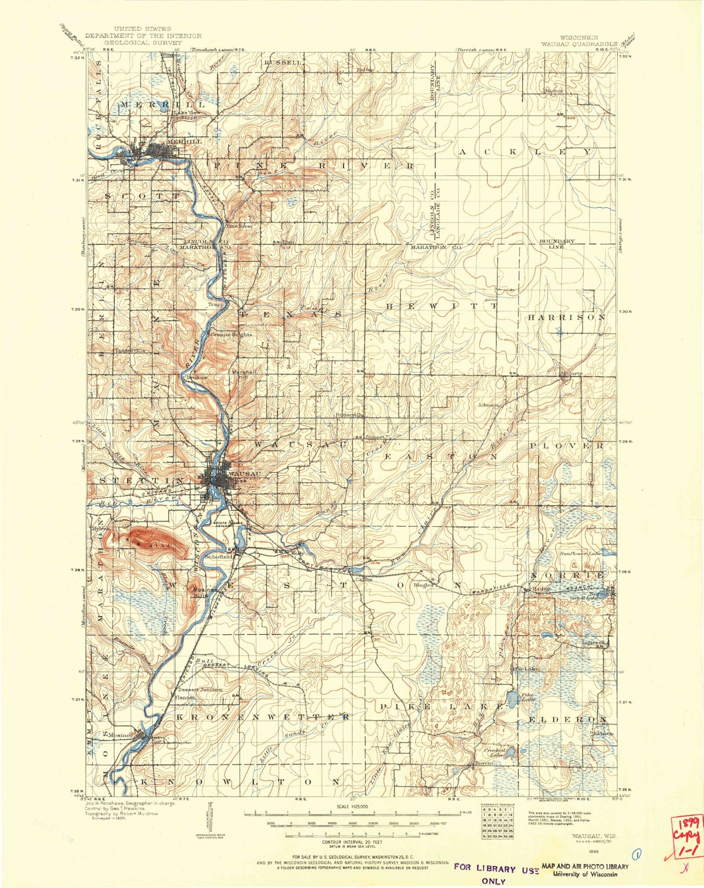
Historical USGS topographic map of Wausau in the state of Wisconsin. Scale: 1:125000. Print size: 17" x 24"
This map was published in 1899 and is in the following counties: Langlade, Lincoln, Marathon.
The map contains contour lines, roads, rivers, towns, streams, and lakes. Printed on high-quality waterproof paper with UV fade-resistant inks.
Contains the following named places: Ackley State Wildlife Areas, Asylum Point, Barkers Island, Barnes Creek, Bass Lake, Bear Lake, Bevent, Big Cain Creek, Big Rib River, Big Sandy Creek, Black Alder Creek, Black Brook, Black Creek, Bohnes Lake, Brokaw, Bull Junior Creek, Callon, Camp Creek, Camp Dell-O-Claire, Camp Phillips, Cedar Creek, Cemetery Slough, Council Grounds State Park, County Line Creek, Dells of the Eau Claire Park, Devil Creek, East Branch Big Sandy Creek, East Branch Pratt Creek, Eau Claire Flowage, Eau Claire River, Fourmile Creek, Fox Lake, Gibson Lake, Go-To-It Lake, Gooding Park, Gospel Lake, Granite Heights, Half Moon Lake, Hammond Park, Hatley, Henrich Lake, Hog Creek, Hogarty, Jim Moore Creek, Kelly, Kennedy Creek, Lentz Creek, Little Brook, Little Bull Junior Creek, Little Cain Creek, Little Eau Claire, Little Frog Lake, Little Hay Meadow Creek, Little Lake, Little Oxbo Creek, Little Rib River, Little Sandy Creek, Little Trappe River, Lloyd Creek, Lost Lake, Mayflower Lake, McCloud Creek, McVay Brook, Merrill, Mission Lake, Mole Brook, Mosinee, Mosinee Flowage, Mosinee Hill, Mud Lake, Muddy Lake, Mystery Lake, Ninemile Swamp, Norrie, Norrie Lake, North Branch Pine River, Nutterville, Otts Park, Oxbo Creek, Pat Smith Creek, Peplin, Lake Pesobic, Pike Lake, Pike Lake Creek, Pine Dells, Pine Island, Pine River, Pleasant View Park, Plover River State Fishery Area, Prahl Creek, Prairie River, Pratt Creek, Prospect Creek, Rajek Creek, Rib Mountain, Rib Mountain State Park, Rice Lake, Rice Lake Creek, Ringle, Riverside Park, Roberts Creek, Rothschild, Sampson Creek, Schofield, Seymour Park, Silver Creek, Skulen Creek, Skunk Creek, Spring Brook, Spring Creek, Steinke Pond, Stewart Park, Stony Creek, Trappe River, Turtle Lake, Wausau, Wausau Junction, Lake Wausau, Wayside Park, Clay Pond, Iron Creek, Sunny Vale Lake, Doering, Glandon, Kalinke, Mount View, Pine River, Snell, Sunset, Taegesville, Riverhills Country Club, Town of Ackley, Town of Easton, Town of Elderon, Town of Harrison, Village of Hatley, Town of Hewitt, Village of Maine, City of Merrill, Town of Merrill, City of Mosinee, Town of Norrie, Town of Pine River, Town of Plover, Town of Reid, Town of Rib Mountain, Town of Ringle, Village of Rothschild, City of Schofield, Town of Scott, Town of Texas, Town of Vilas, City of Wausau, Town of Wausau, Town of Weston, Village of Weston, Weston, Brooks and Ross Dam, Motl 1 G12 121 Dam, Motl 2 G12 121 Dam, Motl 3 G12 121 Dam, Merrill 1874C118 Dam, 2780 Reservoir, Mosinee 1893C138 Dam, Mosinee Flowage 4126, Rothschild 1903C155 Dam, Lake Wausau 4016, Wausau WP342 Dam, Wausau Dam 3092, Langlade County Flowage T1063 G12 684 Dam, 1 Reservoir, Langlade County Flowage T1063 G12 685 Dam, 1 Reservoir, Skunk Creek D12.185 Dam, Gleason Flowage 2, Lincoln County Fair Grounds, Memorial Park, Prairie River State Fishery Area, Andrew Warren Historic District, Athletic Park, Bluegill Bay County Park, Camp Blessing, D C Everest Park, East Hill, Forest Park, Franklin Hill, Gaska Park, Grand Avenue Shopping Center, Indianhead Golf Course, Isle of Ferns Park, Johnson, Kennedy Park, Liberty Park, Marathon County Fairgrounds, Marathon Park, Memorial Park, Mission Lake County Park, Nine Mile Forest, Nine Mile Recreation Area, Oak Island Park, Pike Lake, Rib Mountain Ski Area, Riverside Park, Riverside Plaza Shopping Center, Sandy Beach County Park, Schofield Park, Schulenberg Park, Shooting Range County Park, Sunny Vale County Park, Sunset Park, Sylvan Hill Park, Thom Field, Washington Square, Wausau Center Mall Shopping Center, Wausau West Industrial Park, Williams Park, Evergreen, Rib Mountain, Dutch Corners, Ingersoll, Kronenwetter, Dells of the Eau Claire River State Natural Area, Village of Kronenwetter, Krueger Pines State Natural Area, Helene's Hilltop Orchard, Ruby Red Quarry, Rib Mountain Quarry, Red Granite Quarry, Cold Spring Wausau Quarry, Marathon County Landfill, Mosinee Wastewater Treatment Plant, Wausau City Wastewater Treatment Plant, Furmanek Farms, Dallman Dairy Farm, Leterski Farms, Litza Farms